• Journal of Natural Resources
  • Vol. 35, Issue 8, 1986 (2020)
Jie ZHU1, Jie SU1, Hai-wei YIN1、*, and Fan-hua KONG2
Author Affiliations
  • 1School of Architecture and Urban Planning, Nanjing University, Nanjing 210093, China
  • 2International Institute for Earth System Sciences, Nanjing University, Nanjing 210023, China
  • show less
    DOI: 10.31497/zrzyxb.20200817 Cite this Article
    Jie ZHU, Jie SU, Hai-wei YIN, Fan-hua KONG. Construction of Xuzhou ecological network based on comprehensive sources identification and multi-scale nesting[J]. Journal of Natural Resources, 2020, 35(8): 1986 Copy Citation Text show less
    The location of the study area
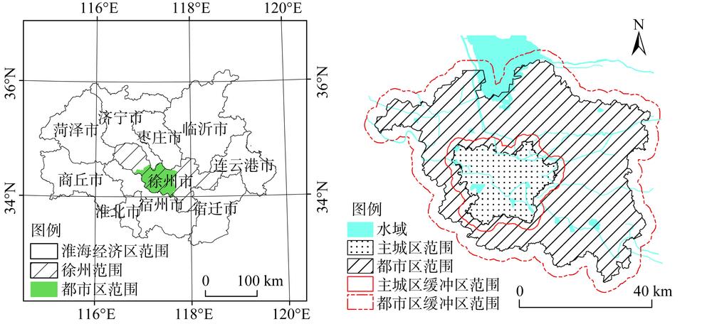
    Fig. 1. The location of the study area
    Technical workflow
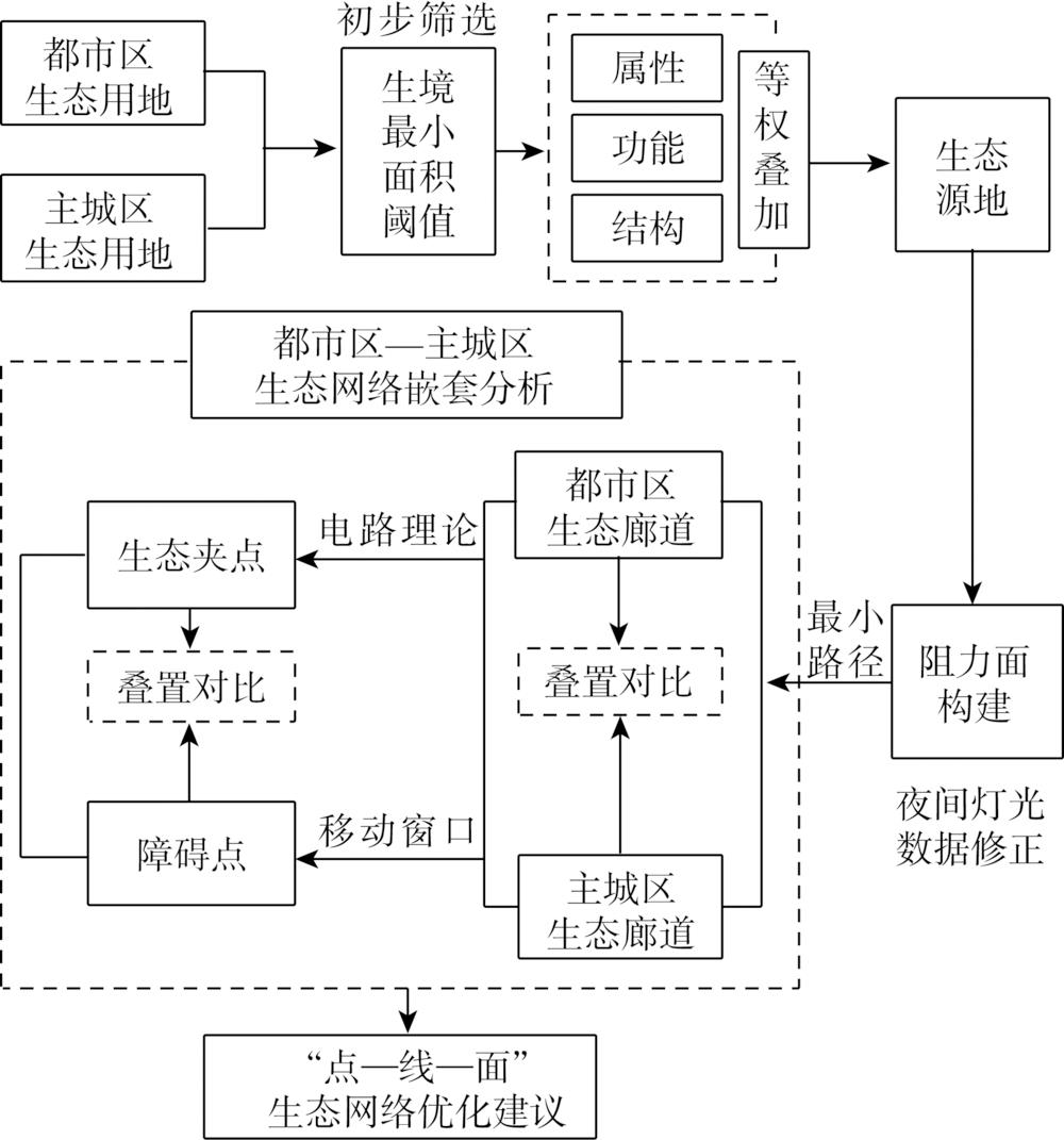
    Fig. 2. Technical workflow
    Area-quantity relation diagram of ecological source area
    Fig. 3. Area-quantity relation diagram of ecological source area
    Selection of minimum area threshold of ecological source area
    Fig. 4. Selection of minimum area threshold of ecological source area
    Factor evaluation of habitat patches and ecological source extraction in metropolitan area
    Fig. 5. Factor evaluation of habitat patches and ecological source extraction in metropolitan area
    Factor evaluation of habitat patches and ecological source extraction in main urban area
    Fig. 6. Factor evaluation of habitat patches and ecological source extraction in main urban area
    Ecological corridors in metropolitan and main urban areas
    Fig. 7. Ecological corridors in metropolitan and main urban areas
    Identification of pinch points and barrier points at different scales
    Fig. 8. Identification of pinch points and barrier points at different scales
    Superposition analysis of ecological core areas and corridors of different scales
    Fig. 9. Superposition analysis of ecological core areas and corridors of different scales
    Comparative analysis of the superimposed areas of pinch points and barrier points
    Fig. 10. Comparative analysis of the superimposed areas of pinch points and barrier points
    数据类型数据来源数据处理
    土地利用分类数据
    (分辨率2.4 m×2.4 m)
    LocaSpace Viewer 2019年2月影像数据:
    http://www.locaspace.cn/LSV.jsp
    目视解译分为农用地、城乡建设用地、未利用地等3大类14小类
    夜间灯光数据
    (分辨130 m×130 m)
    珞珈一号夜光遥感卫星数据:
    http://59.175.109.173:8888/index.html
    使用2018年11月夜间灯光数据
    徐州相关规划专题图件徐州市自然资源与规划局提取徐州都市区、主城区行政区边界
    道路OpenStreetMap:http://www.openstreetmap.org/道路矢量线性要素
    Table 1. Data source and processing
    影响要素缓冲区范围/m重要性赋值
    100 m以上主干河流、500 hm²以上湖泊2001
    4000.8
    6000.6
    8000.4
    50~100 m河流、
    100~500 hm²湖泊
    2000.8
    4000.6
    6000.4
    20~50 m河流、
    50~100 hm²湖泊坑塘
    2000.6
    4000.4
    20 m以下河流、
    50 hm²以下坑塘
    2000.4
    Table 2. Assignment of the importance of water conservation
    大类小类细分分类依据都市区主城区
    分类划分阻力值分类划分阻力值
    农用地耕地水田5050
    旱地10080
    林地面积/hm²>20001>301
    200~20001010~3010
    <20020<1020
    建设用地商服公服
    用地
    城市商服用地600800
    农村商服用地400600
    工矿用地1000800
    公用设施
    用地
    瞻仰景观休闲用地公园绿地30公园绿地30
    防护绿地50防护绿地10
    住宅城市居住用地用地类型一类居住1000一类居住1000
    二类居住1000二类居住1000
    三类居住600三类居住600
    农村居民点面积/hm²>501000>501000
    20~5050020~50600
    <20300<20400
    交通运输
    用地
    交通场站1000600
    铁路8001000
    高速1000900
    公路宽度/m>40800>40700
    20~4060020~40500
    ≤ 20400≤ 20300
    未利用地未利用
    土地
    城区未利用地面积/hm²>10500>10500
    ≤ 10100≤ 10100
    农村荒地面积/hm²>30500>10500
    ≤ 30200≤ 10200
    其他
    土地
    河流水面宽度/m>1001000>501000
    50~10050030~50500
    <50100<30100
    湖泊水面面积/hm²>1001000>80800
    50~10020030~80200
    <5020<3020
    Table 3. Resistance setting of land use types in Xuzhou metropolitan area and main urban area
    Jie ZHU, Jie SU, Hai-wei YIN, Fan-hua KONG. Construction of Xuzhou ecological network based on comprehensive sources identification and multi-scale nesting[J]. Journal of Natural Resources, 2020, 35(8): 1986
    Download Citation