• Journal of Geographical Sciences
  • Vol. 30, Issue 10, 1633 (2020)
Yuanfang CHAI1、2, Yunping YANG3、4、*, Jinyun DENG2, Zhaohua SUN2, Yitian LI2, and Lingling ZHU2
Author Affiliations
  • 1Department of Earth Sciences, Vrije Universiteit Amsterdam, Boelelaan 1085, 1081 HV Amsterdam, The Netherlands
  • 2State Key Laboratory of Water Resources and Hydropower Engineering Science, School of Water Resources and Hydropower Engineering, Wuhan University, Wuhan 430072, China
  • 3State Key Laboratory of Hydrology-Water Resources and Hydraulic Engineering, Hohai University, Nanjing 210098, China
  • 4Key Laboratory of Engineering Sediment, Tianjin Research Institutes for Water Transport Engineering, Ministry of Transport, Tianjin 300456, China
  • show less
    DOI: 10.1007/s11442-020-1804-x Cite this Article
    Yuanfang CHAI, Yunping YANG, Jinyun DENG, Zhaohua SUN, Yitian LI, Lingling ZHU. Evolution characteristics and drivers of the water level at an identical discharge in the Jingjiang reaches of the Yangtze River[J]. Journal of Geographical Sciences, 2020, 30(10): 1633 Copy Citation Text show less
    The location of the middle reaches (Yichang-Luoshan and Jingjiang reaches) of the Yangtze River
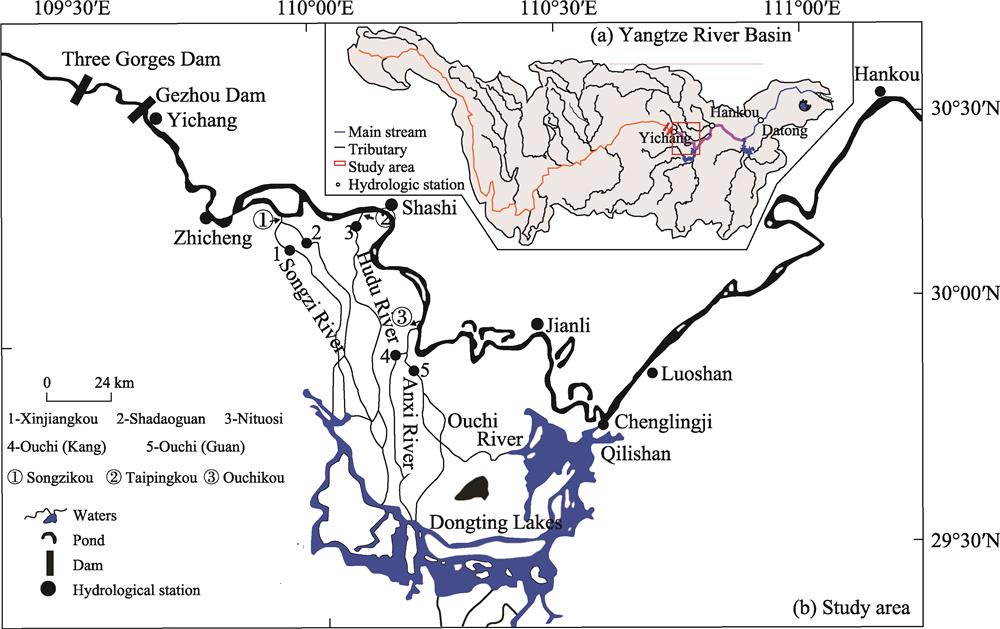
    Fig. 1. The location of the middle reaches (Yichang-Luoshan and Jingjiang reaches) of the Yangtze River
    Measured and simulated water levels at the hydrological stations in 2002, 2009, and 2016
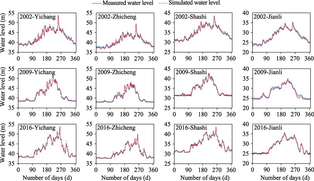
    Fig. 2. Measured and simulated water levels at the hydrological stations in 2002, 2009, and 2016
    Relationships between the water level and water discharge along the middle reaches of the Yangtze River in 2003, 2010, and 2016 at the five hydrological stations
    Fig. 3. Relationships between the water level and water discharge along the middle reaches of the Yangtze River in 2003, 2010, and 2016 at the five hydrological stations
    Cumulative riverbed erosion volumes along the middle reaches of the Yangtze River
    Fig. 4. Cumulative riverbed erosion volumes along the middle reaches of the Yangtze River
    Estimation of the riverbed roughness along the middle reaches of the Yangtze River
    Fig. 5. Estimation of the riverbed roughness along the middle reaches of the Yangtze River
    Variation trends in the average water level under the characteristic flows along the middle reaches of the Yangtze River
    Fig. 6. Variation trends in the average water level under the characteristic flows along the middle reaches of the Yangtze River
    Effects of the influencing factors on changes in the low water levels
    Fig. 7. Effects of the influencing factors on changes in the low water levels
    Variation trends in the flood water level exposed to characteristic flows along the middle reaches of the Yangtze River
    Fig. 8. Variation trends in the flood water level exposed to characteristic flows along the middle reaches of the Yangtze River
    Effects of the influencing factors on the changes in the flood water level
    Fig. 9. Effects of the influencing factors on the changes in the flood water level
    Hydrological station/ReachData typeData characteristicsPeriodData source
    Yichang, Zhicheng, Shashi, Jianli, and LuoshanFlow and water levelDaily, monthly, and annual averages1991-2016Yangtze River Waterway Bureau and Bureau of Hydrology Changjiang Water Resources Commission
    Dongting Lake (three mouths) and Chenglingji
    Yichang-Chenglingji reachTerrainSediment amount2002-2016
    Yichang-Luoshan reachTerrain1:10,000October 2002, October 2009, and October 2016
    Table 1.

    Hydrological and river topography data

    FlowYichangZhichengShashiJianliLuoshan
    Low water flow (m3/s)6,1906,4906,4606,4908,460
    Flood flow (m3/s)46,50046,40037,60034,50045,800
    Table 2.

    Representative discharge rates at the hydrological stations located along the middle reaches of the Yangtze River

    TimeChannel characteristicsΔB > 0 mΔB > 20 mΔB > 50 m
    2003-2009Low-flow channel68.841.628.9
    Backfill channel71.727.216.2
    Flood channel74.622.06.4
    2009-2016Low-flow channel70.546.831.8
    Backfill channel57.825.417.3
    Flood channel38.714.56.94
    2003-2016Low-flow channel71.757.843.9
    Backfill channel60.134.123.1
    Flood channel55.516.86.94
    Table 3.

    Percentage of widened cross-sections along the Yichang-Chenglingji reach

    Hydrological stationPeriod of time
    1991-20032003-20092009-2016
    Yichang51.4851.2451.66
    Zhicheng47.6047.2247.97
    Shashi42.2941.8742.48
    Jianli35.6934.4835.61
    Luoshan31.8731.4732.05
    Table 4.

    Variation characteristics for the flood water level (m)

    Yuanfang CHAI, Yunping YANG, Jinyun DENG, Zhaohua SUN, Yitian LI, Lingling ZHU. Evolution characteristics and drivers of the water level at an identical discharge in the Jingjiang reaches of the Yangtze River[J]. Journal of Geographical Sciences, 2020, 30(10): 1633
    Download Citation