
Yuanfang CHAI, Yunping YANG, Jinyun DENG, Zhaohua SUN, Yitian LI, Lingling ZHU. Evolution characteristics and drivers of the water level at an identical discharge in the Jingjiang reaches of the Yangtze River[J]. Journal of Geographical Sciences, 2020, 30(10): 1633
- Journal of Geographical Sciences
- Vol. 30, Issue 10, 1633 (2020)
Abstract
Keywords
1 Introduction
Water level changes directly affect a river system’s stability, waterway depth, industrial and agricultural water consumption, and the ecological environment (
Previous studies have suggested that changes to riverbeds, including riverbed erosion, have impact on low and flood water levels below dams. Changes in the water level are mainly associated with reservoir operation, riverbed erosion, riverbed roughness, and human activity (
In this study, we collected water discharge and water level data along the Jingjiang portion in the middle reaches of the Yangtze River from 1991 to 2016. Using the polynomial fitting method, we modeled the regression relationship between the water level and water discharge to analyze the variation characteristics of the low and flood water levels at an identical discharge. Using the separation of variables method, we estimated the contributions of riverbed erosion, changes in downstream water levels, and riverbed roughness to water level variations.
2 Materials and methods
2.1 Study area and data collection
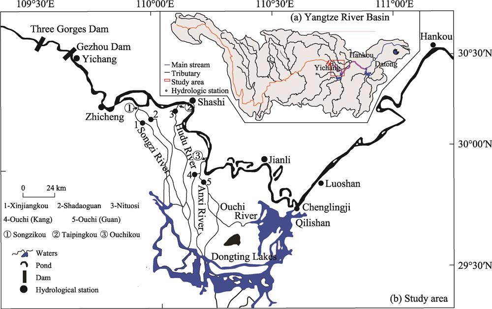
This study targeted the Yichang-Luoshan reach downstream of the Three Gorges Dam, a portion of the Yangtze River channel that extends for 408 km, which can be divided into two parts: the Yichang-Zhicheng reach and the Jingjiang reach. Between Yichang and Luoshan, there are five hydrological stations, from which data was collected for this study, including Yichang, Zhicheng, Shashi, Jianli, and Luoshan (
![]()
Figure 1.
Daily water discharge and water level data from the Yichang, Zhicheng, Shashi, Jianli, Luoshan, Songzikou, Taipingkou, Ouchikou, and Chenglingji stations from 1991-2016 were collected from the Bureau of Hydrology Changjiang Water Resources Commission (BHCWRC) (
| Hydrological station/Reach | Data type | Data characteristics | Period | Data source |
|---|---|---|---|---|
| Yichang, Zhicheng, Shashi, Jianli, and Luoshan | Flow and water level | Daily, monthly, and annual averages | 1991-2016 | Yangtze River Waterway Bureau and Bureau of Hydrology Changjiang Water Resources Commission |
| Dongting Lake (three mouths) and Chenglingji | ||||
| Yichang-Chenglingji reach | Terrain | Sediment amount | 2002-2016 | |
| Yichang-Luoshan reach | Terrain | 1:10,000 | October 2002, October 2009, and October 2016 |
Table 1.
Hydrological and river topography data
Administration. To analyze the effects that various riverbed factors have on the relationship between water discharge and water level during different operation periods of the Three Gorges Dam, we divided the study period into 1991-2003, 2003-2009, and 2009-2016.
2.2 Methods
The major influencing factors on water-level changes at a given discharge include riverbed erosion, riverbed roughness, and downstream control water level. The contribution of each factor can be estimated using the separation of variables method.
2.2.1 Separation of variables method
The separation of variables method is primarily based on river dynamic mechanics, which has been widely used to investigate the effects that individual factors have on variations in a river’s water level (
Based on the flow equation (Eq. (1)), Chezy formula (Eq. (2)), and Manning formula (Eq. (3)), we can derive Eq. (4) as follows:
where
Based on the assumption that the water discharge at the inlet section remains unchanged during the entire period, i.e.,
where subscripts 0 and 1 represent the beginning of the study period and its end, respectively, subscripts “in” and “out” represent the inlet and outlet sections, respectively,
2.2.2 MIKE 11 HD model
Based on separation of variables method, the MIKE 11 HD model was used to estimate the effects that riverbed erosion, riverbed roughness, and the downstream water level control have on the changes in the water level at a specific discharge. This model relies on the following Eqs. (7) and (8), where the water flow continuity and water dynamic equations are as follows:
where
Topographical data for the Yichang-Luoshan reach from 2002, 2009, and 2016 were used as input to run the MIKE 11 HD model. The upper boundary condition was set as the daily water discharge at Yichang station while the daily water level at Luoshan station was used as the lower boundary condition. The water discharge at the three outlets (i.e., the Songzikou, Taipingkou, and Ouchikou outlets) and Chenglingji station were all based on daily data. By verifying the observed water level at the main hydrological stations throughout the Yichang-Luoshan reach, we were able to simulate the comprehensive riverbed roughness along the Yichang-Zhicheng, Zhicheng-Shashi, Shashi-Jianli, and Jianli-Luoshan reaches. As shown in
![]()
Figure 2.
2.2.3 Selection of representative water discharge rates
The variation trends at the low and flood water levels are different for different reaches of the Yangtze River. Thus, a representative water discharge rate must be selected for each hydrological station (
| Flow | Yichang | Zhicheng | Shashi | Jianli | Luoshan |
|---|---|---|---|---|---|
| Low water flow (m3/s) | 6,190 | 6,490 | 6,460 | 6,490 | 8,460 |
| Flood flow (m3/s) | 46,500 | 46,400 | 37,600 | 34,500 | 45,800 |
Table 2.
Representative discharge rates at the hydrological stations located along the middle reaches of the Yangtze River
3 Results
3.1 Water level-discharge rate relationship
We selected 2003, 2010, and 2016 as representative years (
![]()
Figure 3.
3.2 Changes in riverbed erosion
During the period from October 2002 to November 2016 (
![]()
Figure 4.
After operation of the Three Gorges Dam, there was a significant decrease in the number of cumulative days characterized by flood discharge rates. There were reductions in both the width of the flood channel and the frequency at which flooding occurred (
| Time | Channel characteristics | Δ | Δ | Δ |
|---|---|---|---|---|
| 2003-2009 | Low-flow channel | 68.8 | 41.6 | 28.9 |
| Backfill channel | 71.7 | 27.2 | 16.2 | |
| Flood channel | 74.6 | 22.0 | 6.4 | |
| 2009-2016 | Low-flow channel | 70.5 | 46.8 | 31.8 |
| Backfill channel | 57.8 | 25.4 | 17.3 | |
| Flood channel | 38.7 | 14.5 | 6.94 | |
| 2003-2016 | Low-flow channel | 71.7 | 57.8 | 43.9 |
| Backfill channel | 60.1 | 34.1 | 23.1 | |
| Flood channel | 55.5 | 16.8 | 6.94 |
Table 3.
Percentage of widened cross-sections along the Yichang-Chenglingji reach
3.3 Changes in riverbed roughness
Since 2003, the sediment concentration along the middle reaches of the Yangtze River has been relatively low, which has caused riverbed scouring and coarsening (
![]()
Figure 5.
4 Discussion
The factors that influence changes in the water level at a specific discharge rate mainly include the riverbed geomorphology, riverbed roughness, and downstream water level control. To further estimate the contribution of each factor, we calculated the riverbed roughness along the Yichang-Zhicheng, Zhicheng-Shashi, Shashi-Jianli, and Jianli-Luoshan reaches using the MIKE 11 HD model, with observed data on the riverbed geomorphology, daily water discharge, and daily water level from 2002, 2009, and 2016 as the input. Based on the control variable principle, we used input data concerning the riverbed geomorphology, riverbed roughness, and downstream water level control to the MIKE 11 HD model to estimate the contributions of these factors to the changes in the water level at a specific discharge rate.
4.1 Changes in low-flow water level and influencing factors
4.1.1 Changes in low-flow water level
Using the least squares method, we determined the relationships between the daily water levels and daily discharge rates. Except for those at Yichang station in 2016 and Jianli station in 2015, the correlation coefficients at the other hydrological stations were all higher than 0.95. Based on the regression equation, we were able to calculate the water levels corresponding to their representative water discharge rates. From 1991-2003, the low-flow water level at each station showed a weak decreasing trend (
![]()
Figure 6.
4.1.2 Influencing factors on changes in the low-flow water level
Before the operation of the Three Gorges Dam in 2003, the low-flow water level showed a decreasing trend, which was mainly caused by riverbed erosion and cut-bend projects (
![]()
Figure 7.
(1) From 2003-2016, the low-flow water levels at Yichang, Zhicheng, Shashi, and Jianli stations decreased by 0.48 m, 0.66 m, 1.73 m, and 0.79 m, respectively. From 2003-2009, the low-flow water levels at the same stations decreased by 0.26, 0.13, 0.62, and 0.65 m, respectively. From 2009-2014, the water levels decreased by 0.22 m, 0.53 m, 1.11 m, and 0.14 m, respectively.
(2) From 2003-2016, changes in the topography, riverbed roughness, and downstream water level control caused a reduction in the low-flow water level at Yichang, Zhicheng, Shashi, and Jianli stations, with reductions of up to 0.46 m, 0.74 m, 1.81 m, and 0.82 m, respectively. Among these influencing factors, reduced water levels attributable to changes in the river topography reached 0.47 m, 1.43 m, 2.38 m, and 1.25 m, respectively. The variations in the downstream water level also decreased the low-flow water levels, with effects reaching 0.32 m, 0.22 m, 0.11 m, and 0.14 m, respectively. In contrast, the increased riverbed roughness elevated the low-flow water levels, reaching 0.33 m, 0.91 m, 0.68 m, and 0.57 m, respectively.
(3) Compared with the situation from 2003-2009, riverbed erosion from 2009-2016 decreased along the Yichang-Zhicheng reach, such that the effects of riverbed erosion on the low-flow water level also declined at Yichang station. Along the Zhicheng-Shashi and Shashi-Jianli reaches, the effects of riverbed erosion became more intense on the low-flow water level. This indicates that regions with severe riverbed erosion had migrated downstream to sandy riverbeds. At the same time, there was also an increase in the reduction of the upstream water level due to downstream riverbed erosion. At Jianli station, downstream riverbed erosion had little effect on the low-flow water level.
(4) Compared with 2003-2009, riverbed armoring along the Yichang-Zhicheng reach from 2009-2016 was basically completed. Thus, the influence of changes in riverbed roughness along this reach was alleviated. From 2009-2016, riverbed armoring along the Zhicheng-Shashi reach intensified. Thus, there was also an enhancement of the effects that the increased riverbed roughness along this reach had on the low-flow water levels. Along the Shashi-Jianli and Jianli-Luoshan reaches, the level of riverbed armoring was limited, thus having little effect on the low-flow water levels at Shashi and Jianli stations.
In conclusion, from 2003-2016, riverbed erosion was the dominant factor that reduced the low-flow water level along the Yichang-Chenglingji reach. Since 2009, riverbed scouring along the Yichang-Zhicheng reach has weakened, such that there has also been a decrease in its contribution to the reduction of the low-flow water level. Along the Jingjiang reach, there has been a decrease in the contribution of riverbed erosion. Increased riverbed roughness restrained the reduced low-flow water level while this positive effect declined along the Yichang-Zhicheng reach since 2009, as riverbed armoring was essentially completed. In contrast, the positive effects of riverbed armoring became more intense along the Jingjiang reach.
4.2 Changes in flood water levels and influencing factors
4.2.1 Changes in flood water levels
From 1991-2002, the flood water levels at a specific discharge rate showed no significant variation trends at the Yichang-Luoshan stations (
![]()
Figure 8.
| Hydrological station | Period of time | ||
|---|---|---|---|
| 1991-2003 | 2003-2009 | 2009-2016 | |
| Yichang | 51.48 | 51.24 | 51.66 |
| Zhicheng | 47.60 | 47.22 | 47.97 |
| Shashi | 42.29 | 41.87 | 42.48 |
| Jianli | 35.69 | 34.48 | 35.61 |
| Luoshan | 31.87 | 31.47 | 32.05 |
Table 4.
Variation characteristics for the flood water level (m)
In general, larger-scale riverbed erosion is mainly distributed in the low-flow channel, which reduces the water level in rivers. The reduced water level was mainly due to a reduced low-flow water level. We suggest that, from 2003-2009 and 2009-2016, the Jingjiang reach experienced scouring while the flood water level exhibited no significant downward trend. Compared with that from 2003-2009, the number of days of overbank flooding decreased from 2009-2016 due to the operation of cascade reservoirs, which increased vegetation growth in the river system. The increased vegetation growth increased the riverbed resistance, thus increasing the flood water level. Simultaneously, numerous waterway regulation works, including revetments, bridges, and ports, were completed during 2009-2016, further increasing the flood water level.
4.2.2 Influencing factors on flood water levels
Before the operation of the Three Gorges Dam, the flood water level showed no evident variation trends at Yichang, Zhicheng, and Shashi stations. Along the Jianli-Luoshan reach, sedimentation of the riverbed was the dominant reason for the increased high water level (
![]()
Figure 9.
(1) From 2003-2016, the high water levels at a specific discharge rate increased by 0.41 m, 0.69 m, 0.71 m, and 1.53 m at Yichang, Zhicheng, Shashi, and Jianli stations, respectively, from 2003-2009, the values were 0.36 m, 0.63 m, 0.10 m, and 0.11 m, respectively, and the values from 2009-2016 were 0.05 m, 0.06 m, 0.61 m, and 1.42 m, respectively.
(2) From 2003-2016, the total effects that the changes in the riverbed topography, riverbed roughness, and downstream water level control had on the flood water level at Yichang, Zhicheng, Shashi, and Jianli stations were 0.41 m, 0.69 m, 0.76 m, and 1.46 m, respectively. The decrease in the flood water levels is attributable to riverbed erosion that reached 0.70 m, 1.26 m, 0.74 m, and 0.41 m, respectively. Changes in the downstream water level control increased the flood water levels up to 0.39 m, 0.23 m, 0.33 m, and 0.17 m, respectively. The increased riverbed roughness also increased the flood water level by up to 0.72 m, 1.72 m, 1.17 m, and 1.70 m, respectively.
(3) The effects of riverbed erosion on the reduced flood water level at Yichang, Shashi, and Jianli stations were mitigated from 2009-2016 compared with those from 2003-2009. In contrast, riverbed erosion along the Zhicheng-Shashi reach intensified, which further reduced the high water level. Greater riverbed armoring occurred from 2003-2009 than in 2009-2016. Thus, changes in the riverbed roughness had little effect on the flood water level along the Yichang-Zhicheng and Zhicheng-Shashi reaches from 2009-2016, with a relatively reduction of its contributions. From 2003-2009, variations in the downstream water level control had highly significant effects on the flood water level at Yichang station, whereas it had little effect on the high water level at Yichang, Shashi, and Jianli stations, contributing changes of less than 0.10 m. From 2009-2016, the effects of the downstream water level control were minor at Yichang station, whereas changes at Zhicheng, Shashi, and Jianli stations were 0.10-0.30 m.
In conclusion, the increased riverbed roughness was the dominant factor that increased the flood water level. Since 2009, riverbed armoring has been basically complete along the Yichang-Zhicheng reach, such that there was a reduction in its effects. Along the Jingjiang reach, the effects of riverbed armoring intensified. Riverbed erosion mitigated the increased high water level during the flood season while the contributions of these effects have decreased along the Yichang-Zhicheng reach since 2009. In contrast, the effects of riverbed erosion on the increased high water level in the Jingjiang reach intensified due to increased riverbed scouring.
5 Conclusions
This study investigated the Jingjiang reach in the middle reaches of the Yangtze River. Using the polynomial regression curve fitting method, we analyzed the variation characteristics of the water levels at representative water discharge rates. Using the MIKE 11 HD model and separation of variables method, we estimated the contributions of changes in the riverbed topography, riverbed roughness, and downstream water level control to water level variations from 1991-2003, 2003-2009, and 2009-2016. Our main conclusions are as follows.
(1) From 1991-2016, the low-flow water level showed a downward trend, which intensified after 2009. From 1991-2016, the flood-flow water level in Jingjiang first decreased and then increased. Before 2003, the high water level can be characterized as “high water discharge at high water levels,” whereas after 2003, the high water level was better characterized as “medium water discharge at high water levels.”
(2) Riverbed erosion was the dominant factor that affected the reduced low-flow water level along the Yichang-Chenglingji reach. Since 2009, riverbed scouring decreased along the Yichang-Zhicheng reach, such that the effects of riverbed erosion on the reduced low water levels also decreased. Along the Jingjiang reach, riverbed scouring intensified, which also increased the reductions to the low-flow water level. The increased riverbed roughness inhibited reductions in the low-flow water level. Since 2009, riverbed armoring has been basically completed along the Yichang-Zhicheng reach, such that it has had little effect on inhibiting reductions to the water level. However, riverbed armoring remained intense throughout the Jingjiang reach, further mitigating reductions to the low-flow water levels.
(3) Increased riverbed roughness was the dominant factor affecting the increased high water level. Since 2009, riverbed armoring throughout the Yichang-Zhicheng reach was basically completed, such that this factor had little effect on the increased high water level. In contrast, the effects of riverbed armoring increased along the Jingjiang reach while riverbed erosion mitigation increases in the high water level. Since 2009, the riverbed along the Yichang-Zhicheng reach experienced reduced scouring, such that there was a reduction in the restraining effect of scouring on high water level increases. In contrast, the effects that riverbed erosion had on constraining the increased high water level intensified.
In this study, we did not consider the effects of riverbed erosion in the three outlets, river flow diversion, or embouchement on erosion in the main stream riverbed nor on the relationship between the water discharge rate and water level. Riverbed roughness was estimated using models affected by vegetation growth and navigation projects. In future studies, we will consider the above effects as potential factors that influence the relationship between the water levels and discharge rates.
References
[1] BormannH, PinterN, ElfertS. Hydrological signatures of flood trends on German Rivers: Flood frequencies, flood heights and specific stages. Journal of Hydrology, 404, 50-66(2011).
[2] BurnsA, Walker KF. Effects of water level regulation on algal biofilms in the River Murray, South Australia. River Research and Applications, 16, 433-444(2015).
[3] Carle MV, Sasser CE, Roberts HH. Accretion and vegetation community change in the Wax Lake delta following the historic 2011 Mississippi River flood. Journal Coastal Research, 313, 569-587(2015).
[4] Chai YF, Li YT, Yang YP et al. Water level variation characteristics under the impacts of extreme drought and the operation of the Three Gorges Dam. Frontiers Earth Science, 13, 510-522(2019).
[5] Cheng JH, XiangR, Qiu XF et al. Analysis of the impact on roughness of riverbed erosion downstream the Three Georges Project. Express Water Resources & Hydropower Information, 33, 59-63(2012).
[6] Dai SP, Yan JB, ZouT et al. A study of the impact of bottle-neck reach evolution downstream from Gezhouba on Yichang low water level. Express Water Resources & Hydropower Information, 33, 40-44(2012).
[7] GabrielA. Impacts, perceptions, and management of shoreline hazards and water levels on a fluctuating reservoir: A case study of the Winnebago System, Wisconsin. Lake Reservoir Management, 20, 197-210(2004).
[8] Greene SL, Knox JC. Coupling legacy geomorphic surface facies to riparian vegetation: Assessing red cedar invasion along the Missouri River downstream of Gavins Point Dam, South Dakota. Geomorphology, 204, 277-286(2014).
[9] GuoY, Sun ZH, Luo FB. Time-variation characteristics and causes of Yichang low-water level since impoundment of Three Gorges Reservoir. Hydro-Science and Engineering, 35-42(2017).
[10] Han JQ, Sun ZH, Li YT et al. Changes and causes of lower water level in Yichang-Chenglingji reach after impounding of Three Gorges Reservoir. Engineering Journal of Wuhan University, 44, 685-690(2011).
[11] Han JQ, Sun ZH, Li YT et al. Combined effects of multiple large-scale hydraulic engineering on water stages in the middle Yangtze River. Geomorphology, 298, 31-40(2017).
[12] Han JQ, Sun ZH, Yang YP. Flood and low stage adjustment in the middle Yangtze River after impoundment of the Three Gorges Reservoir (TGR). Journal of Lake Sciences, 29, 1217-1226(2017).
[13] Huang XL, Wang WK, Zhu MH et al. “2016.7” flood last danger analysis and revelation in the middle and lower reaches of the Yangtze River. China Flood & Drought Management, 47-49(2016).
[14] Lai XJ, Jiang JH, Yang G S et al. Should the Three Gorges Dam be blamed for the extremely low water levels in the middle-lower Yangtze River?. Hydrological Processes, 28, 150-160(2014).
[15] Li YT, Sun ZH, LiuY et al. Channel degradation downstream from the Three Gorges Project and its impacts on flood level. Journal of Hydraulic Engineering, 135, 718-728(2009).
[16] Li YZ. Change in Yangtze water level along Yichang stretch in dry season. China Three Gorges Construction, 9, 12-14(2002).
[17] Lu JY. Variation of stage-discharge relationship of downstream of hydro-junction. Hydro-Science and Engineering, 109-117(1994).
[18] Mei XF, Dai ZJ, Du JZ et al. Linkage between Three Gorges Dam impacts and the dramatic recessions in China’s largest freshwater lake, Poyang Lake. Scientific Reports, 5, 18197(2016).
[19] Moshe LB, HavivI, EnzelY et al. Incision of alluvial channels in response to a continuous base level fall: Field characterization, modeling, and validation along the Dead Sea. Geomorphology, 93, 524-536(2008).
[20] Shields JR, DouglasF, SimonA et al. Reservoir effects on downstream river channel migration. Environmental Conservation, 27, 54-66(2000).
[21] Sun ZH, HuangY, Cao QX et al. Spatial and temporal variations of the low flow stage in the immediate downstream reach of the Three Georges Dam. Journal of Basic Science and Engineering, 23, 694-704(2015).
[22] SurianN, ZilianiL, ComitiF et al. Channel adjustments and alteration of sediment fluxes in gravel-bed rivers of North-Eastern Italy: Potentials and limitations for channel recovery. River Research & Applications, 25, 551-567(2010).
[23] Topping DJ, Schmidt JC, Vierra LE. Computation and analysis of the instantaneous discharge for the Colorado River at Lees Ferry, Arizona. USA: US Geological Survey Professional Paper, 30-33(2013).
[24] Yang YP, Zhang MJ, Li YT et al. Suspended sediment recovery and bedsand compensation mechanism affected by the Three Gorges Project. Acta Geographica Sinica, 71, 1241-1254(2016).
[25] Yang YP, Zhang MJ, Liu WL et al. Relationships between waterway depth and low-flow water levels in reaches below the Three Gorges Dam. Journal of Waterway, Port, Coastal, and Ocean Engineering, 145, 04018032(2019).
[26] Yang YP, Zhang MJ, Sun ZH et al. The relationship between water level change and river channel geometry adjustment in the downstream of the Three Gorges Dam (TGD). Acta Geographica Sinica, 72, 776-789(2017).
[27] Yang YP, Zhang MJ, Sun ZH et al. The relationship between water level change and river channel geometry adjustment in the downstream of the Three Gorges Dam. Journal of Geographical Sciences, 28, 1943-1961(2018).
[28] Yang YP, Zhang MJ, Zhu LL et al. Influence of large reservoir operation on water-levels and flows in reaches below dam: Case study of the Three Gorges Reservoir. Scientific Reports, 7, 15640(2017).
[29] Yuan WH, Yin DW, FinlaysonB et al. Assessing the potential for change in the middle Yangtze River channel following impoundment of the Three Gorges Dam. Geomorphology, 27-34(2012).
[30] ZhangM, Zhou JJ, Huang GX. Flood control problems in middle reaches of Yangtze River and countermeasures. Water Resources Protection, 32, 1-10(2016).
[31] ZhangW, Yang YP, Zhang MJ et al. Mechanisms of suspended sediment restoration and bed level compensation in downstream reaches of the Three Gorges Projects (TGP). Journal of Geographical Sciences, 27, 463-480(2017).
[32] Zhang XB, Lu JY, Lin QS. Preliminary study on accumulated influence of the bankline use on flood control in the middle and lower reaches of the Yangtze River. Resources and Environment in the Yangtze Basin, 20, 1138-1142(2011).

Set citation alerts for the article
Please enter your email address
© Copyright 2018-2021 | Chinese Laser Press. All Rights Reserved 沪ICP备15018463号-20