• Journal of Geo-information Science
  • Vol. 22, Issue 3, 338 (2020)
Sijin LI1、1、2、2、3、3, Wen DAI1、1、2、2、3、3, Liyang XIONG1、1、2、2、3、3、*, and Guoan TANG1、1、2、2、3、3
Author Affiliations
  • 1Key Laboratory of Virtual Geographic Environment (Nanjing Normal University), Ministry of Education, Nanjing 210023, China
  • 1虚拟地理环境教育部重点实验室(南京师范大学),南京 210023
  • 2School of Geography, Nanjing Normal University, Nanjing 210023, China
  • 2南京师范大学地理科学学院,南京 210023
  • 3Jiangsu Center for Collaborative Innovation in Geographical Information Resource Development and Application, Nanjing 210023, China
  • 3江苏省地理信息资源开发与利用协同创新中心,南京 210023
  • show less
    DOI: 10.12082/dqxxkx.2020.190352 Cite this Article
    Sijin LI, Wen DAI, Liyang XIONG, Guoan TANG. Uncertainty of the Morphological Feature Expression of Loess Erosional Gully Affected by DEM Resolution[J]. Journal of Geo-information Science, 2020, 22(3): 338 Copy Citation Text show less
    Workflow of uncertainty of the morphological feature expression of loess erosional gully
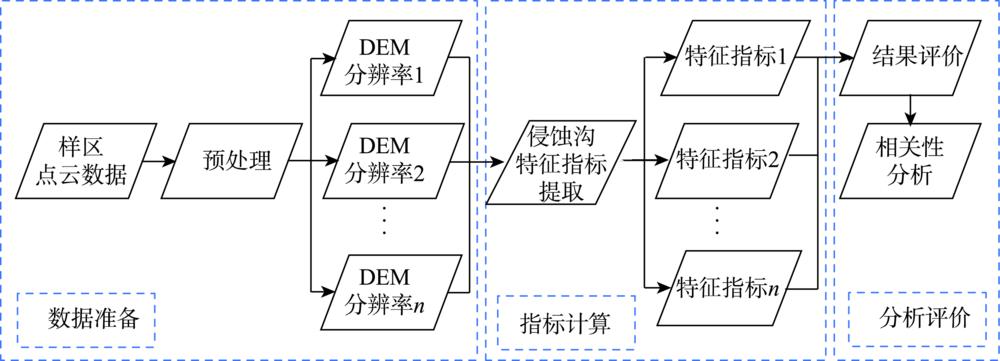
    Fig. 1. Workflow of uncertainty of the morphological feature expression of loess erosional gully
    Sketch map of illumination model
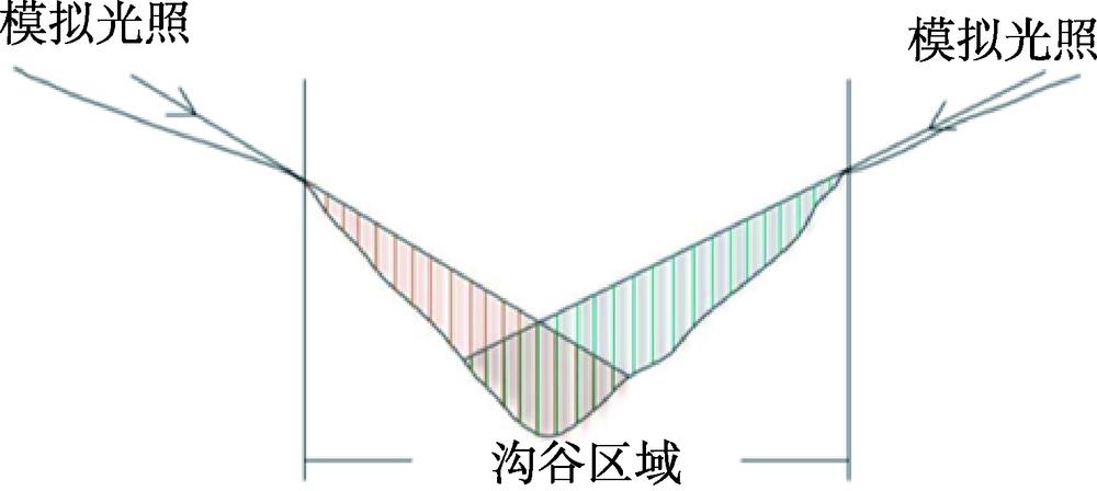
    Fig. 2. Sketch map of illumination model
    Location of the study areas and digital elevation model data
    Fig. 3. Location of the study areas and digital elevation model data
    The results of gully indicators and the relationships between gully channel indicators and DEM resolutions
    Fig. 4. The results of gully indicators and the relationships between gully channel indicators and DEM resolutions
    The influence of DEM resolution on gully cutting depth
    Fig. 5. The influence of DEM resolution on gully cutting depth
    The results of gully head indicators and the relationships between gully head indicators and DEM resolutions
    Fig. 6. The results of gully head indicators and the relationships between gully head indicators and DEM resolutions
    样区
    12345678910
    麻地沟35020010080706050404040
    安塞35020015012010010080706050
    桥沟35015010080807060505050
    Table 1. The appropriate threshold value for gully network extraction of sample areas (m)
    样区位置面积/km2海拔/m侵蚀沟特点
    安塞37°14'24"N—37°14'27"N,109°14'41"E—109°14'53"E0.501163.7~1416.5主沟道呈东西走向,南面浅沟和切沟发育多,北面下切侵蚀强烈,发育3条较大的切沟,较少发育浅沟
    麻地沟37°28'59"N—37°28'49"N,108°48'2"E—108°48'35"E0.231396.8~1556.8主沟道呈南北走向,浅沟和切沟发育较多
    桥沟37°34'10"N—37°34'16"N,104°16'49"E—104°16'57"E0.13900.9~1017.1主沟道呈西南—东北走向,两侧发育有较多浅沟和切沟
    Table 2. Basic information and features of study areas
    Sijin LI, Wen DAI, Liyang XIONG, Guoan TANG. Uncertainty of the Morphological Feature Expression of Loess Erosional Gully Affected by DEM Resolution[J]. Journal of Geo-information Science, 2020, 22(3): 338
    Download Citation