• Acta Geographica Sinica
  • Vol. 75, Issue 9, 1921 (2020)
Yu YUAN*, Guohua FANG, Chengxuan LU, and Min YAN
Author Affiliations
  • College of Water Conservancy and Hydropower Engineering, Hohai University, Nanjing 210098, China
  • show less
    DOI: 10.11821/dlxb202009008 Cite this Article
    Yu YUAN, Guohua FANG, Chengxuan LU, Min YAN. Flood risk assessment under the background of urbanization based on landscape ecology[J]. Acta Geographica Sinica, 2020, 75(9): 1921 Copy Citation Text show less
    Location of Qinhuai river basin and distribution of sub-basins
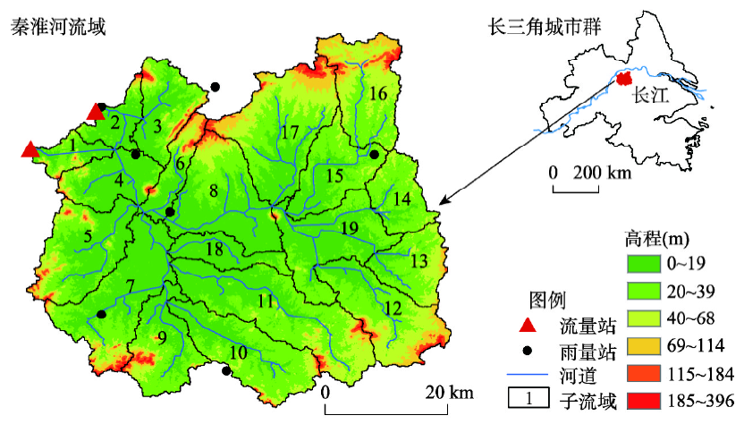
    Fig. 1. Location of Qinhuai river basin and distribution of sub-basins
    Landscape distribution maps and the samples in the study area
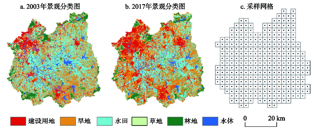
    Fig. 2. Landscape distribution maps and the samples in the study area
    Sketch map of HEC-HMS model
    Fig. 3. Sketch map of HEC-HMS model
    The calibration and validation results of HEC-HMS model
    Fig. 4. The calibration and validation results of HEC-HMS model
    Correlation analysis results of flood-landscape
    Fig. 5. Correlation analysis results of flood-landscape
    Regression analysis results of flood-landscape
    Fig. 6. Regression analysis results of flood-landscape
    Spatial distribution of flood-landscape ecological risk for 2003 and 2017
    Fig. 7. Spatial distribution of flood-landscape ecological risk for 2003 and 2017
    Landscape and flood-landscape ecological risk distribution of No.7 and No.8 sub-basins
    Fig. 8. Landscape and flood-landscape ecological risk distribution of No.7 and No.8 sub-basins
    数据类型时间(年份)精度来源
    降雨1986—20161 d资源环境数据云平台(http://www.resdc.cn), 南京气象局
    流量1986—20161 d
    太阳辐射、气温1986—20161 d
    土壤20091 km世界和谐土壤数据库HWSD 1.1
    数字高程200930 m中国科学院计算机网络信息中心地理空间数据云平台(http://www.gscloud.cn)
    遥感影像1988, 1994, 1999, 2003, 2010, 201730 m
    Table 1. The data used in this study
    洪号景观分布年份RNSEDv(%)Dp(%)
    率定期1987063019880.960.913.53-9.23
    1993061819940.940.8625.440.39
    2003062620030.980.8722.8812.84
    2008061520100.990.997.663.85
    验证期1987081919880.950.8118.2713.64
    1991062919880.830.80-3.8120.21
    1996062319940.990.8929.322.60
    1999062219990.950.8229.257.87
    2002061820030.980.96-0.29-6.95
    2006071820030.980.8921.1119.50
    2015071220170.950.880.77-7.36
    Table 2. Summary of calibration and validation results for simulation at daily step
    Yu YUAN, Guohua FANG, Chengxuan LU, Min YAN. Flood risk assessment under the background of urbanization based on landscape ecology[J]. Acta Geographica Sinica, 2020, 75(9): 1921
    Download Citation