• Journal of Natural Resources
  • Vol. 35, Issue 1, 106 (2020)
Hai HUANG1、2、*, Shun YANG1、2, You TIAN1、2, and Zhong-sheng XIE1、2
Author Affiliations
  • 1Institute of Exploration Technology, CAGS, Chengdu 611734, China
  • 2Technical Center for Geological Hazard Prevention and Control, CGS, Chengdu 611734, China
  • show less
    DOI: 10.31497/zrzyxb.20200110 Cite this Article
    Hai HUANG, Shun YANG, You TIAN, Zhong-sheng XIE. The debris flow disaster land use and ecological restoration measures in Wenchuan earthquake hard-hit disaster areas: A case study in the small watershed of Duba River[J]. Journal of Natural Resources, 2020, 35(1): 106 Copy Citation Text show less
    The sketch map of Duba River Basin
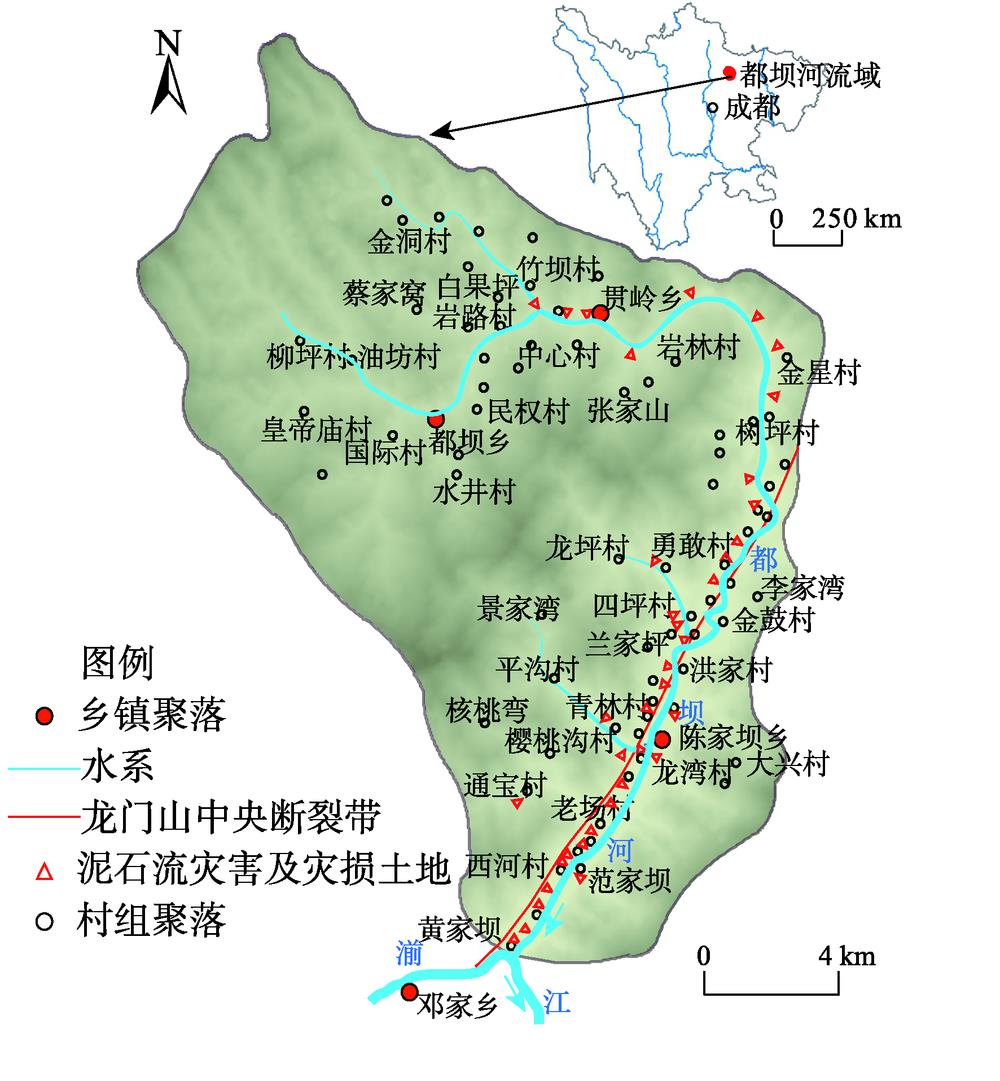
    Fig. 1. The sketch map of Duba River Basin
    The symbiotic relationship between the debris flow and settlements in the lower Duba River
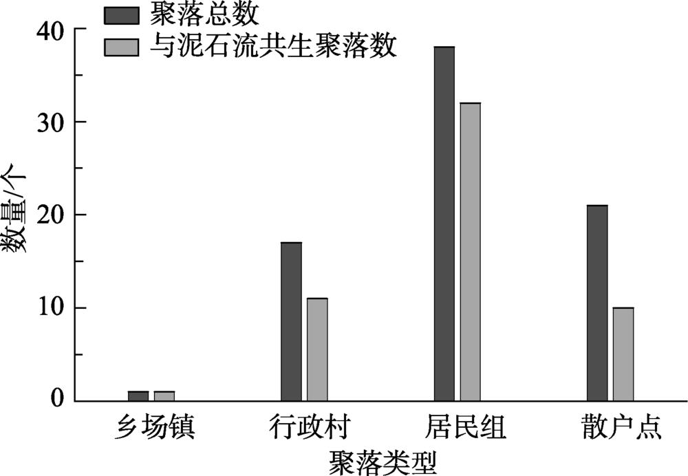
    Fig. 2. The symbiotic relationship between the debris flow and settlements in the lower Duba River
    The frame diagram of the research method
    Fig. 3. The frame diagram of the research method
    The partition of disaster land use for the risk assessment of debris flow
    Fig. 4. The partition of disaster land use for the risk assessment of debris flow
    The type of typical disaster land in Duba River Basin
    Fig. 5. The type of typical disaster land in Duba River Basin
    Ecological restoration model of the debris flow disaster land
    Fig. 6. Ecological restoration model of the debris flow disaster land
    The disaster land use patterns and ecological restoration measures in the small watershed of Yangjia gully
    Fig. 7. The disaster land use patterns and ecological restoration measures in the small watershed of Yangjia gully
    分区分区标准土地利用方式建议确定依据
    P=1%标准下的非危险区建设储备土地受大于100年一遇的灾害影响,且随着泥石流演化,风险逐渐降低,根据小型村落或工业建筑设防标准,可作为建设储备用地
    P=2%标准下的非危险区,P=1%标准下的危险区产业化农用地可能遭遇50年一遇~100年一遇的灾害威胁,遭遇灾害重现期较长,可作为产业化农业用地
    P=5%标准下的非危险区,P=2%标准下的危险区季节性农用地可能遭遇20年一遇~50年一遇的泥石流灾害威胁,遭遇灾害重现期中等,极端天气频现的现状下,可作为季节性普通农业用地
    P=10%标准下的非危险区,P=5%标准下的危险区产业化林地可能遭遇10年一遇~20年一遇的泥石流灾害威胁,遭遇灾害重现期短,为防止经济作物遭受损失,可作为林业产业用地,同时还可以成为灾害防护林
    P=10%标准下的危险区灾害缓冲区的生态林地可能遭遇10年一遇的泥石流灾害威胁,是山洪及泥石流常用泻流通道,可作为灾害缓冲区域,布设灾害治理工程及防灾生物措施
    Table 1. The suggestions on land use patterns by different frequency disaster risks
    序号土壤质量等级划分标准(有机质含量/%)土地资源化利用建议
    1较优>3优质耕地,结合土地流转与整治,建立现代化特色农业种植基地
    2良好3~2普通耕地,种植当地适宜农作物,如玉米、土豆
    3一般2~1产业林地,规模化种植经济林木或果木,如核桃
    4较差<1生态(景观)林地,种植适应强的乔木或灌木,建立水土保持林
    Table 2. The classification of disaster land quality using a single factor
    序号泥石流
    名称
    行政村灾前利用方式灾损土地
    面积/hm2
    损坏类型现状利用
    方式
    耕地面积/hm2未利用地
    占比/%
    1韩家山沟杜家坝村耕地1.4淤埋荒地100.0
    2李家湾沟金鼓村李家湾组耕地1.1淤埋荒地100.0
    3杨家沟太洪村耕地34.3淤埋、冲刷荒地100.0
    4四坪沟四坪村耕地1.2淤埋荒地100.0
    5兰家坪沟四坪村兰家坪组耕地0.6淤埋荒地100.0
    6头道河红岩村耕地3.4淤埋荒地100.0
    7大竹沟大竹村耕地7.9淤埋荒地、耕地1.877.2
    8石家岩沟陈家坝场镇耕地0.8淤埋、冲刷荒地100.0
    9青林沟龙湾村耕地26.6淤埋、冲刷荒地、耕地2.490.9
    10张家沟老场村耕地26.5淤埋、冲刷荒地100.0
    11鼓儿山泥石流龙湾村耕地22.7淤埋荒地、耕地6.670.9
    12凤凰村沟凤凰村耕地10.5淤埋荒地、耕地4.854.3
    Table 3. The distribution characteristics of typical debris flow disaster land in the lower Duba River
    Hai HUANG, Shun YANG, You TIAN, Zhong-sheng XIE. The debris flow disaster land use and ecological restoration measures in Wenchuan earthquake hard-hit disaster areas: A case study in the small watershed of Duba River[J]. Journal of Natural Resources, 2020, 35(1): 106
    Download Citation