• Journal of Geo-information Science
  • Vol. 22, Issue 3, 370 (2020)
Shangmin ZHAO1、1、*, Weiming CHENG2、2, Jingtian JIANG3、3, and Wenjuan SHA4、4
Author Affiliations
  • 1Department of Surveying and Mapping, College of Mining Engineering, Taiyuan University of Technology, Taiyuan 030024, China
  • 1太原理工大学矿业工程学院测绘科学与技术系,太原 030024
  • 2State Key Laboratory of Resources and Environmental Information System, Institute of Geographic Sciences and Natural Resources Research Chinese Academy of Sciences, Beijing 100101, China
  • 2中国科学院地理科学与资源研究所 资源与环境信息系统国家重点实验室,北京 100101
  • 3Eastern General Aero photography Company Limited, Taiyuan 030031, China
  • 3东方通用航空摄影有限公司,太原 030031
  • 4Suzhou Image Sky International Company Limited, Suzhou 215163, China
  • 4苏州中科天启遥感科技有限公司,苏州 215163
  • show less
    DOI: 10.12082/dqxxkx.2020.190658 Cite this Article
    Shangmin ZHAO, Weiming CHENG, Jingtian JIANG, Wenjuan SHA. Error Comparison among the DEM Datasets Made from ZY-3 Satellite and the Global Open Datasets[J]. Journal of Geo-information Science, 2020, 22(3): 370 Copy Citation Text show less
    Relief map of the research area of Taiyuan city
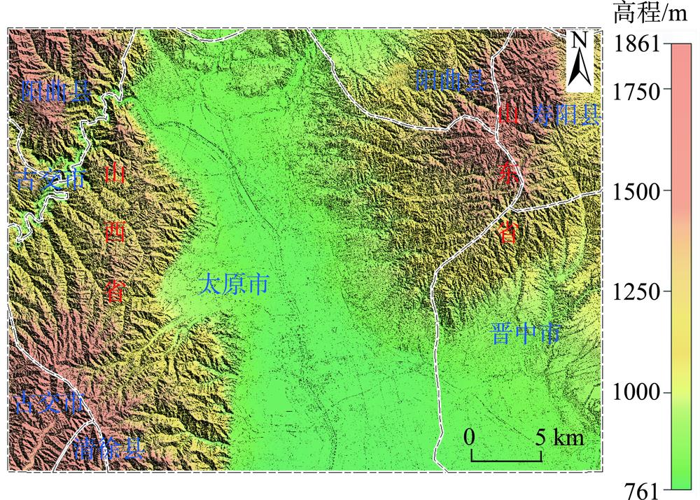
    Fig. 1. Relief map of the research area of Taiyuan city
    Diagram of computation method ofthe relative error between referencing DEM and other DEM data
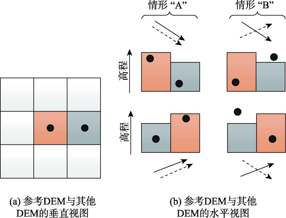
    Fig. 2. Diagram of computation method ofthe relative error between referencing DEM and other DEM data
    Pixel number distribution of the absolute error values at different numerical ranges for the four DEM datasets
    Fig. 3. Pixel number distribution of the absolute error values at different numerical ranges for the four DEM datasets
    Computation resultsof the relative error for the four DEM datasets
    Fig. 4. Computation resultsof the relative error for the four DEM datasets
    DEM数据空间分辨率/m精度*/m获取时间/年覆盖范围
    参考DEM50.152014太原市及周边地区
    资源三号DEM582019南北纬84°之间
    AW3D30 DEM303.42006—2011南北纬82°之间
    SRTM1 DEM3092000南北纬60°之间
    ASTER GDEM3012.62000—2009南北纬83°之间
    Table 1. Brief Introduction to the DEM datasets in this research
    DEM数据坡度/°0~22~77~1515~2525~35>35
    (控制点数量/个)(45 259)(37 131)(16 301)(37 594)(22 065)(23 936)
    ME资源三号DEM1.51.10.71.01.21.3
    AW3D30 DEM2.31.81.24.62.13.0
    SRTM1 DEM1.11.00.1-0.00.41.3
    ASTER GDEM V31.0-0.0-0.70.41.83.3
    MAE资源三号DEM2.32.32.52.93.33.9
    AW3D30 DEM3.12.72.83.64.45.6
    SRTM1 DEM2.53.55.46.88.010.1
    ASTER GDEM V37.07.18.69.911.312.6
    RMSE资源三号DEM3.73.74.14.66.05.9
    AW3D30 DEM5.54.44.14.96.28.3
    SRTM1 DEM3.85.57.69.210.915.4
    ASTER GDEM V39.59.711.413.014.918.4
    STD资源三号DEM3.43.54.14.55.95.7
    AW3D30 DEM5.04.13.94.65.87.8
    SRTM1 DEM3.65.57.69.210.915.3
    ASTER GDEM V39.59.711.413.014.718.1
    Table 2. ME, MAE, RMSE and STD values of theabsolute error for the four DEM datasets at different slope classes (m)
    DEM数据坡度/°0~22~77~1515~2525~35>35
    (点对数量/对)(198 276)(119 526)(87 624)(121 341)(118 908)(80 882)
    MAE资源三号DEM1.82.12.83.13.54.2
    AW3D30 DEM2.32.53.23.94.66.0
    SRTM1 DEM2.23.56.07.48.711.2
    ASTER GDEM V35.66.38.29.811.413.6
    RMSE资源三号DEM3.23.64.35.25.96.3
    AW3D30 DEM4.44.24.65.36.48.8
    SRTM1 DEM3.55.88.610.111.916.3
    ASTER GDEM V37.78.711.113.015.018.5
    Table 3. MAEand RMSE values of the relative errorfor the four DEM datasets at different slope classes (%)
    Shangmin ZHAO, Weiming CHENG, Jingtian JIANG, Wenjuan SHA. Error Comparison among the DEM Datasets Made from ZY-3 Satellite and the Global Open Datasets[J]. Journal of Geo-information Science, 2020, 22(3): 370
    Download Citation