• Journal of Geo-information Science
  • Vol. 22, Issue 1, 11 (2020)
Nengcheng CHEN1、1、*, Changjiang XIAO2、2, Chao YANG3、3, and Wei WANG1、1
Author Affiliations
  • 1State Key Laboratory for Information Engineering in Surveying, Mapping and Remote Sensing, Wuhan University, Wuhan 430079, China
  • 1武汉大学测绘遥感信息工程国家重点实验室,武汉 430079
  • 2College of Surveying and Geo-Informatics, Tongji University, Shanghai 200092, China
  • 2同济大学测绘与地理信息学院,上海 200092
  • 3School of Geography and Information Engineering, China University of Geosciences, Wuhan 430074, China
  • 3中国地质大学(武汉)地理与信息工程学院, 武汉 430074
  • show less
    DOI: 10.12082/dqxxkx.2020.190479 Cite this Article
    Nengcheng CHEN, Changjiang XIAO, Chao YANG, Wei WANG. Technology and Application of the Fusion Service of Geospatial Sensor Web[J]. Journal of Geo-information Science, 2020, 22(1): 11 Copy Citation Text show less
    Cyber-physically integrated and flexible spatiotemporal information service technology
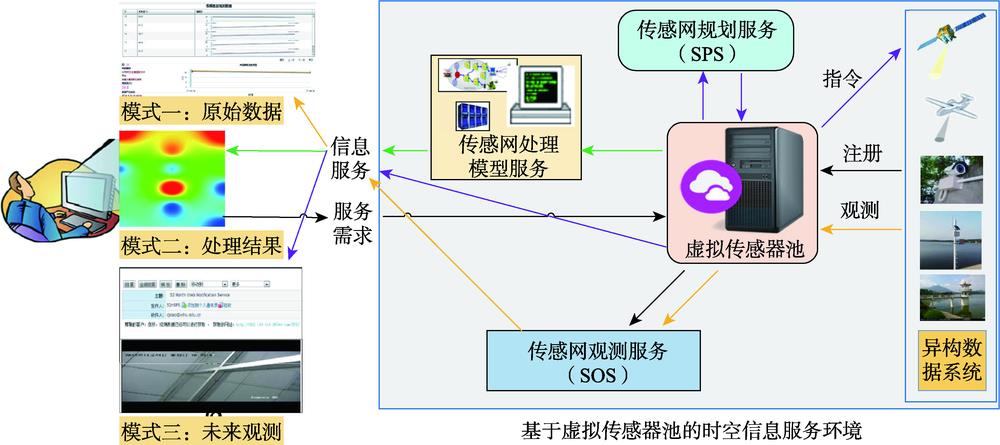
    Fig. 1. Cyber-physically integrated and flexible spatiotemporal information service technology
    Sensor Web observation sharing information model
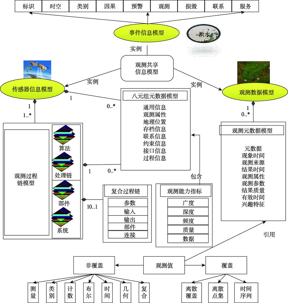
    Fig. 2. Sensor Web observation sharing information model
    Seamless reconstruction model based on point-surface collaboration
    Fig. 3. Seamless reconstruction model based on point-surface collaboration
    End-to-end prediction of sea surface temperature field by the proposed spatiotemporal deep learning model
    Fig. 4. End-to-end prediction of sea surface temperature field by the proposed spatiotemporal deep learning model
    Principle of the optimal coverage of sensor web nodes
    Fig. 5. Principle of the optimal coverage of sensor web nodes
    Architecture of GeoSensor
    Fig. 6. Architecture of GeoSensor
    Information sharing among 21 reservoirs in the middle and upper reaches of the Yangtze river
    Fig. 7. Information sharing among 21 reservoirs in the middle and upper reaches of the Yangtze river
    Spatiotemporal prediction of sea surface temperature
    Fig. 8. Spatiotemporal prediction of sea surface temperature
    Integrated analysis and decision-making support for urban emergencies
    Fig. 9. Integrated analysis and decision-making support for urban emergencies
    Nengcheng CHEN, Changjiang XIAO, Chao YANG, Wei WANG. Technology and Application of the Fusion Service of Geospatial Sensor Web[J]. Journal of Geo-information Science, 2020, 22(1): 11
    Download Citation