
Huan JING, Deyu ZHONG, Hongwu ZHANG, Xufang SHI, Yanjun WANG. Accumulation phenomena in fluvial processes and the corresponding stochastic model[J]. Journal of Geographical Sciences, 2020, 30(6): 1021
- Journal of Geographical Sciences
- Vol. 30, Issue 6, 1021 (2020)
Abstract
Keywords
1 Introduction
In nature, physical processes with different spatial and temporal scales are the results of accumulated internal and/or external effects. Accumulation phenomena are commonly observed in various natural processes, including fluvial systems. Generally, in a fluvial system, the runoff and sediment from the basin are the basic inputs of material and energy, and their accumulation is the fundamental driving force of all kinds of fluvial processes. For instance, as a flow carrying sediment enters a wide river valley or estuary, the dramatic widening of the water surface causes a sharp decrease in flow velocity and substantial sediment deposition, which eventually contributes to the formation of alluvium and an estuarine delta. This pattern explains the formation of the North China Plain in the lower Yellow River and the Yangtze Delta adjacent to the East China Sea (
In the past few decades, the accumulation effects of previous water and sediment conditions have attracted considerable attention.
Numerous studies have also been carried out to investigate the spatial changes in fluvial systems following disturbances. Based on long-term water and sediment observations and corresponding topographic data,
In general, previous studies have concentrated on the adjustment characteristics of cumulative channel variables (e.g., accumulated sedimentation, channel bank-full dimensions), which directly reflect the cumulative effects of previous water-sediment conditions. Based on these studies, it can be concluded that accumulation characteristics are inherent in fluvial processes, and it is reasonable to think that the accumulation effects of water and sediment conditions in the early period played an essential role in river evolution. Many studies have demonstrated that the channel geometry is affected by both current and past water and sediment conditions. However, most previous studies accounted for the cumulative effects of historical water-sediment conditions using the arithmetic mean, sliding mean, and numerical iteration methods, which cannot depict the physical patterns or fundamentally reveal the physical mechanisms of accumulation phenomena in fluvial processes. Furthermore, few studies have considered the spatial propagation characteristics of responses to external disturbances. In this study, we seek to (1) provide a mathematical description of the accumulation phenomena resulting from internal responses to external disturbances in fluvial processes and (2) develop a comprehensive theoretical model for simulating the spatiotemporal readjustments of characteristic river variables based on the stochastic theory in statistical mechanics. The proposed models are then applied to investigate the spatiotemporal readjustments of the upper and lower reaches of the rivers following the construction of dams. The results provide the theoretical basis and a new calculation method for quantitatively describing the spatiotemporal readjustments of non-equilibrium fluvial channels following disturbances.
2 Accumulation phenomena in fluvial processes
2.1 Study cases
Field observations of the upstream and downstream reaches of dams on several representative fluvial channels (the Colorado River and Missouri River in the United States, and the Yellow River, Yangtze River, and Hanjiang River in China) were collected. The corresponding characteristic river parameters of the studied cross-sections and channel reaches are shown in
| Project | River | Average pre- dam daily discharge (m3/s) | Average post- dam daily discharge (m3/s) | Studied cross-section or reach | Distance | Variable | Survey | Survey number |
|---|---|---|---|---|---|---|---|---|
| Hoover | Colorado | 520 | 400 | CHD-1-CHD-3 | 10-36 | Riverbed degradation | 1935-1948 | 15 |
| Parker | 230 | 340 | CPD-1-CPD-3 | 39-95 | 1938-1975 | 16 | ||
| Davis | 400 | 340 | CDD-1-CDD-2 | 1-9 | 1948-1975 | 28 | ||
| Fort Peck | Missouri | 200 | 280 | MFP-1-MFP-3 | 9-75 | Channel width | 1936-1973 | 8 |
| Garrison | 600 | 660 | MGD-1-MGD-3 | 32-54 | 1949-1976 | 6 | ||
| Gavins Point | 930 | 740 | MGP-1-MGP-3 | 7-48 | 1955-1974 | 5 | ||
| Danjiangkou | Hanjiang | 1335 | 1091 | HJG-HZ | 3-270 | Water level | 1960-1976 | 6 |
| Sanmenxia | Yellow | 1522 | 1412 | XLD-LJ | 61-678 | Accumulated erosion and deposition amount | 1961-1984 | 21 |
| SZ-TG | - | 1965-1984 | 20 | |||||
| Xiaolangdi | Yellow | 1266 | 807 | XLD-LJ | 61-678 | 2000-2015 | 16 | |
| Three Gorges | Yangtze | 14027 | 12873 | YC-HK | 30-807 | 2003-2016 | 14 |
Table 1.
Characteristic river parameters for the studied cross-sections and channel reaches (Williams and Wolman, 1987; Jia, 1992; Peng et al., 2016; Yang et al., 2017)
2.2 Adjustment of characteristic river parameters
2.2.1 Vertical adjustment
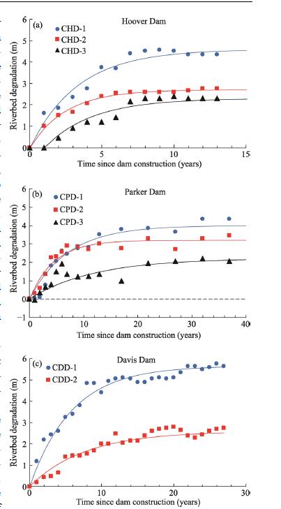
Dam construction on rivers tends to destroy the previous equilibrium state and trigger the riverbed reformation of the lower reaches downstream of the dam (
Temporally, the riverbed in downstream reaches showed significant erosion and incision, and the accumulated riverbed degradation gradually increased over time (
![]()
Figure 1.
2.2.2 Lateral adjustment
As mentioned previously, the amount of sediment entering the reaches downstream of a dam is dramatically reduced by the operation of the reservoir. If the mainstream still oscillates in the lateral direction, and the erosion resistance of the channel bank is relatively poor, significant collapse may occur in the floodplain, leading to considerable widening of the fluvial channel (
![]()
Figure 2.
2.2.3 Longitudinal adjustment
The altered flow and sediment regimes caused by reservoir operation usually induce considerable readjustment of the longitudinal profile in reaches downstream of a dam site. With the development of riverbed erosion, the suspended sediment concentration in the lower reaches gradually recovers along the channel, and the erosion intensity declines. In this study, the longitudinal readjustments of downstream reaches after dam construction were investigated based on the observed water levels in typical cross-sections downstream of the Danjiangkou Reservoir along with the accumulated erosion amounts in channel reaches downstream of the Sanmenxia Reservoir, Xiaolangdi Reservoir, and Three Gorges Reservoir (
![]()
Figure 3.
The erosion quantity was much larger in the HYK-GC Reach (Huayuankou-Gaocun Reach; that is HJ Reach and JG Reach in
2.2.4 Overall adjustment in the entire reach
The Sanmenxia Reservoir has experienced serious sedimentation since dam construction. To reduce the sedimentation rate in the reservoir area, several sediment management strategies have been implemented. These include twice project reconstructions (July 1966-August 1968 and December 1970-December 1973) and three changes in operation modes. The operation modes were as follows: storage mode (September 1960-March 1962), flood detention mode (April 1962-October 1973), and controlled release mode (since November 1973) (
Figure 4 shows the temporal variations in sedimentation in the Sanmenxia Reservoir area and the lower Yellow River. The accumulated sediment amounts in both the reservoir area upstream Tongguan Station and the entire lower Yellow River generally increased over time with a larger sedimentation rate at first followed by a smaller one. The fluvial systems gradually approached dynamic equilibrium during the studied period. Since the operation mode of the Sanmenxia Reservoir changed from flood detention mode to controlled release mode, an obvious inflection point appears in
![]()
Figure 4.
As mentioned previously, the spatiotemporal adjustments of the reaches upstream and downstream of dams in fluvial channels were analyzed comprehensively. The vertical, lateral, longitudinal, and overall adjustments indicate the following. Temporally, the adjustment rates of morphological variables were large in the first few years after dam construction and then declined rapidly over time. The accumulated riverbed degradation, channel width, and accumulated sedimentation amount continuously increased until a new dynamic equilibrium was reached. These phenomena reflect the representative accumulation characteristics of fluvial processes. Spatially, the erosion intensity in the downstream reaches decreased nonlinearly along the channel until eventually diminishing. The imbalanced spatial distribution of erosion intensity arose from the property of system response characterized by propagation in space but decay over time, which is an external manifestation of accumulation characteristics in fluvial processes after a disturbance. It can be concluded that accumulation is an inherent property of fluvial processes and must be considered when studying the evolution of rivers.
3 Theoretical framework
Under the effects of external disturbances, the establishment of a new dynamic equilibrium in a river via self-regulatory behavior is essentially the accumulation of continuous internal responses induced by external disturbances over time. In this study, accumulation effects were studied based on the stochastic theory proposed by
where I(t) is the accumulation action, which represents the accumulated effects of external disturbances and can be regarded as a characteristic parameter of fluvial channels; F(t) is the response intensity induced by an individual disturbance; and tk is the time at which a disturbance occurs. The accumulation of internal responses caused by external disturbances is shown in
![]()
Figure 5.
Riverbed adjustment mainly occurs during flood seasons (
N(t) always equals zero unless it increases by one in micro time internal dt. In other words, μ(t) has the property of a Dirac delta function (i.e., $\int_{{\rm{ - }}\infty }^\infty {\mu (t)dt = 1}$).Therefore, the integral form of accumulation action I(t) can be expressed as
Notably, when both t< 0 and when t→$\infty ,$ the internal response intensity F(t) that is the initial adjustment rate of a characteristic river variable equals zero; that is, the fluvial channel does not respond when an external disturbance has not yet occurred or a long time has passed since the external disturbance. As shown in previous studies, the responses of rivers commonly follow the law of exponential decay. For example, the development of gullies under substantial climatic changes (
where qis the initial response intensity (i.e., the initial adjustment rate of a characteristic channel parameter); and αis the attenuation coefficient of response intensity, which varies widely between rivers and reflects the climate and water-sediment properties. The external disturbance causes an imbalance between sediment transport capacity and the previous sediment concentration; this is the basic driving force of the readjustment of the riverbed. A large αvalue corresponds to a fast decline in the above imbalance and a fast adjustment of the river to the disturbance (i.e., the new dynamic equilibrium state is reached quickly). For the convenience of calculation, α is assumed to be a constant.
Substituting equation (4) into equation (3) gives
Taking the derivative of accumulation action I(t) with respect to time t gives
Equation (6) can be simplified into
Equation (7) is a stochastic differential equation, and the driving force is provided by the term on the right. Equation (7) indicates that the adjustment rate of a characteristic river variable is related to the magnitude of the response intensity, the attenuation rate, and the frequency of the external disturbance.
The fluctuation quantity η(t) is defined as the difference between dN(t) and its mean value:
Equation (7) can be transformed into
Substitute μ(t) =dN(t)/dtand η(t) = dN(t)-λdtinto equation (9) gives
Taking the expectation of both sides of equation (10) and considering that$\left\langle {qd\eta (t)} \right\rangle = 0$, one obtains
Taking the limit t→$\infty$, the equilibrium value of the characteristic channel variable adjusted towards can be expressed as
Then, the first-order ordinary differential equation of accumulation effects can be obtained as
Equation (13) indicates that after an external disturbance, the adjustment rate of a characteristic river variable will gradually decrease as the equilibrium value is approached. That is, the fluvial system gradually moves toward the new equilibrium state. By solving equation (13), the theoretical model for the temporal adjustment of characteristic river parameters can be obtained as follows:
where $\left\langle {I(\infty )} \right\rangle$ is the asymptotic value of a characteristic cumulative river variable; $\left\langle {I(t)} \right\rangle$ is the value of that variable at time t; and $\left\langle {{I_0}} \right\rangle$ is the initial value of the variable at t=0. Equation (14) can be used to describe the readjustments of characteristic river parameters over time following a disturbance. The values of the coefficient αand equilibrium value $\left\langle {I(\infty )} \right\rangle$ are generally related to the water-sediment properties, the composition of the riverbed, and the geologic and climatic characteristics of the river basin. The form of equation (14) is consistent with the delayed response model (
Next, we studied the spatial distributions of responses to external effects to provide a scientific basis for predicting the spatial adjustments of river morphological variables after disturbances. The accumulation action $\left\langle {I(t)} \right\rangle$ is a function of both spatial and temporal factors, where the position in space is also related to time t. Thus equation (14) can be transformed into
Substituting v = dx/dtinto equation (15) gives
By solving equation (16), a theoretical model for the spatial adjustments of characteristic river parameters can be obtained as follows:
where vis the propagation velocity of external effects; α/vis the spatial attenuation coefficient; $\left\langle {{I_{x0}}} \right\rangle$ is the value of a characteristic parameter at the initial position; and $\left\langle {I(\infty )} \right\rangle$ is the corresponding equilibrium value of that. Equation (17) can be used to describe the readjustments of characteristic river parameters along the channel after a disturbance. The propagation velocity vis also related to the water-sediment properties, the composition of the riverbed, and the climatic characteristics of the basin. For example, 12.3 years after the construction of the Milburn Dam in the United States, the downstream scour reached 7.4 km away from the dam site; in contrast, four years after the construction of the Hoover Dam, the downstream scour reached 117 km from the dam site (Williams and Wolman, 1987). Thus, the spatial and temporal scales of the cumulative response are closely related to the basin properties and strength of the disturbance.
4 Model application
4.1 Dimensionless equation
Through equation transposition and deformation, the theoretical models proposed above for simulating the spatiotemporal readjustments of characteristic river variables can be nondimensionalized as
and
The term on the left side of equation (18) represents the relative readjustment of the characteristic variable over time with respect to the values at t=0 and in the new equilibrium state. Correspondingly, the left side of equation (19) represents the relative readjustment of the characteristic variable along the channel with respect to the value at the disturbance point where the system response has not yet started declining and the value where the effects of the external disturbance have vanished completely.
4.2 Simulation of spatiotemporal adjustments
When using the above theoretical models to simulate the spatio-temporal readjustments of characteristic river variables, the undetermined model parameters need to be calibrated. Based on observed hydrological measurements, the values of αand α/vfor each studied cross-section and channel reach were obtained via nonlinear regression analysis (Tables 2 and 3).
The values of relative adjustment for each set of measured data can be obtained via equation deforming referring to the left dimensionless term shown in the above equation (18) and equation (19) based on the calibrated model parameters. The dimensionless points were then divided into four types: vertical readjustment, lateral readjustment, longitudinal readjustment, and readjustment of all channel reaches overall (
![]()
Figure 6.
| Vertical | Lateral | Overall readjustment (entire reach) | |||
|---|---|---|---|---|---|
| CHD-1-CHD-3 | 0.30, 0.40, 0.30 | MGP-1-MGP-3 | 0.40, 0.45, 0.50 | SZ-TG | 0.40 |
| CPD-1-CPD-3 | 0.14, 0.22, 0.09 | MFP-1-MFP-3 | 0.18, 0.15, 0.05 | LYR (1968-1975) | 0.45 |
| CDD-1-CDD-2 | 0.17, 0.16 | MGD-1-MGD-3 | 0.60, 0.25, 0.40 | LYR (1976-1984) | 0.40 |
Table 2.
Parameter values in equation (18)
| Longitudinal | |
|---|---|
| HJG-HZ (1965-1975) | 0.0160, 0.0120, 0.0090 |
| XLD-LJ (1961-1964) | 0.0065, 0.0060, 0.0042, 0.0038 |
| XLD-LJ (2003-2015) | 0.0100, 0.0050, 0.0050 |
| YC-HK (2003-2015) | 0.0033, 0.0033, 0.0025 |
Table 3.
Parameter values in equation (19)
The vertical, lateral, longitudinal, and overall spatiotemporal readjustments of the channels all conformed to the same unified theoretical curve. Temporally, the adjustment rates of accumulated riverbed degradation, channel width, and accumulated erosion amount in the studied cross-sections and channel reaches were much larger in the relatively earlier stage and then declined exponentially over time until new dynamic equilibrium states were reached (Figures 6a, 6b, and 6d). Spatially, the cumulative river characteristic variables (i.e., the accumulated changes in water level and accumulated erosion amounts) showed similar variations as above. As the weighted distance to the dam site increased, the rates of change in these variables decreased nonlinearly along the channel until eventually diminishing, reflecting typical negative exponential attenuation behavior (
4.3 Examples of model application
The following cross-sections and reaches were selected as examples to investigate the spatiotemporal adjustments of rivers using the developed models: CHD-2 downstream of the Hoover Dam on the Colorado River; MFP-1 downstream of the Fort Peck Dam on the Missouri River; HJG-HZ Reach downstream of the Danjiangkou Reservoir on the Hanjiang River; and SZ-TG Reach in the Sanmenxia Reservoir area on the Yellow River (
Figures 7a and 7b show the changes in riverbed degradation and channel width in the CHD-2 and MFP-1 cross-sections. The adjustment rates in both the vertical and lateral directions were large in the early period after dam construction and then decreased gradually over time. The determination coefficient R2 between the measured and calculated values was 0.99.
![]()
Figure 7.
As shown in
5 Discussion
The proposed theoretical models derived from the accumulation phenomena in fluvial processes are generally consistent with the widely used delayed response model in terms of their form. The delayed response model assumes that the adjustment rate of a river morphological variable is proportional to the difference between its value at any time and the asymptotic value. By taking the adjusted result at each time step as the initial condition of the next time step, the cumulative effects of early water and sediment conditions on later riverbed adjustments were considered. Also, the delayed response models were successfully applied to simulate sedimentation in the Sanmenxia Reservoir and the adjustments of channel bankfull morphological dimensions in the lower reaches of the Yellow River over time (
In the proposed theoretical models, the unknown temporal attenuation coefficient αand the spatial attenuation coefficient α/vare the most crucial parameters directly determining the relative adjustment rates of channel morphological variables.
![]()
Figure 8.
6 Conclusions
In this study, the spatiotemporal adjustments of river morphological variables following disturbances were analyzed, and corresponding theoretical models were proposed to describe the accumulation characteristics in fluvial processes. The key conclusions are summarized as follows:
(1) Temporally, the readjustment rates of channel variables following disturbances generally decreased nonlinearly over time. Riverbed degradation, channel width, and accumulated sedimentation increased continuously after dam construction until a new dynamic equilibrium was reached. This phenomenon reflects the accumulation characteristics of fluvial processes. Spatially, the erosion intensity downstream from the dam decreased nonlinearly along the channel until completely diminishing far from the dam. The imbalanced spatial distribution of erosion intensity results from a system response characterized by propagation in space but decay over time.
(2) Assuming that the probability of the external disturbance conforms to a Poisson distribution, and that the response intensity induced by an individual disturbance decays exponentially over time, a mathematical equation describing the temporal accumulation of system responses resulting from external disturbances was proposed. Moreover, the corresponding theoretical models for simulating the spatiotemporal readjustments of characteristic river variables were developed.
(3) The spatiotemporal readjustments of channel morphological variables in the upstream and downstream reaches of dams were simulated using the proposed models. The spatiotemporal readjustments of rivers were accurately described by the developed unified theoretical formula. The model predictions showed good agreements with observed field data with R2=0.92, 0.93, 0.76, and 0.95 for vertical, lateral, longitudinal, and overall readjustment, respectively. In general, it is essential to consider both the accumulation characteristics of fluvial processes and the spatial propagation of system responses to simulate the spatiotemporal readjustments of characteristic river parameters. These factors are the fundamental drivers of river evolution.
(4) The undetermined temporal attenuation coefficient αand the spatial attenuation coefficient α/vare the most crucial parameters in the proposed theoretical models. These parameters determine the relative adjustment rates of channel morphological variables to some extent and play an essential role in channel evolution. In this paper, αand α/vwere considered to be constants, and the effects of channel flow-sediment regimes and riverbed composition were not considered. These effects should be further investigated in the future.
References
[1] J G Chen, C H Hu, Z D Dong et al. Change of bankfull and bed-forming discharges in the lower Yellow River. Journal of Sediment Research, 10-16(2006).
[2] N Chien, W H Zhou, R J Hong. The characteristics and genesis analysis of the braided stream of the lower Yellow River. Acta Geographica Sinica, 28, 1-27(1961).
[3] N Chien. Changes in river regime after the construction of upstream reservoirs. Earth Surface Processes and Landforms, 10, 143-159(1985).
[4] R S Fu, M L Qi, H W Fang et al. Sediment transport characteristics of Yangtze River in river section from Yichang to Hankou. Journal of Hydraulic Engineering, 36, 35-41(2005).
[5] C W Gardiner. Stochastic Methods. Vol. 4. Berlin: Springer(2009).
[6] W L Graf. The rate law in fluvial geomorphology. American Journal of Science, 277, 178-191(1977).
[7] J M Hooke. River channel adjustment to meander cutoffs on the River Bollin and River Dane, Northwest England. Geomorphology, 14, 235-253(1995).
[8] R M Jia. Effect of bed erosion and fall of water at the lower reach of Danjiangkou Reservoir on the waterway. Journal of Waterway and Harbor, 12-22(1992).
[9] D Knighton. Fluvial Forms and Processes: A New Perspective. London: Routledge(1998).
[10] Z Y Liang, L F Yang, P L Feng. Relations of channel geometry to water and sediment rate for the lower Yellow River. Journal of Hydroelectric Engineering, 24, 68-71(2005).
[11] N Liu. On the control of Tongguan elevation and operation mode of Sanmenxia Reservoir. Journal of Hydraulic Engineering, 36, 1019-1028(2005).
[12] J Z Pang. Some observations on the management strategy of the lower Yellow River. Yellow River, 27, 3-4(2005).
[13] T Peng, H Yan, J L Guo et al. Impact of Danjiangkou Reservoir operation on downstream hydrological regime. Yangtze River, 47, 22-26(2016).
[14] N Qian, R Zhang, Z D Zhou. Riverbed Evolution(1987).
[15] Y Y Qian, Z Wu, C X Zhu. Preliminary analysis on maintaining effective storage capacity of reservoirs on heavy sediment-laden river. In: Compilation of Reservoir Sediment Reports, Communication Meeting about the Sediment Observation and Research Achievements of the Yellow River Reservoir. Zhengzhou: Yellow River Institute of Hydrau, 102-111(1972).
[16] P H Rahn. Erosion below main stem dams on the Missouri River. Bulletin of the Association of Engineering Geologists, 14, 157-181(1977).
[17] G A Richard. Quantification and prediction of lateral channel adjustments downstream from Cochiti Dam, Rio Grande, NM. Fort Collins: Colorado State University(2001).
[20] G Q Wang, B S Wu, Z Y Wang. Sedimentation problems and management strategies of Sanmenxia Reservoir, Yellow River, China. Water Resources Research, 41, W09417(2005).
[21] S J Wang. Channel pattern specialities and the formation of the lower reaches of the Yellow River. Acta Geoscientica Sinica, 24, 73-78(2003).
[22] Z Y Wang, C Z Li, F X Wang. Effect of Tongguan’s elevation on the fluvial process of the lower Weihe River. Journal of Hydraulic Engineering, 35, 1-8(2004).
[24] G P Williams, M G Wolman. Downstream effects of dams on alluvial rivers. United States Geological Survey Professional Paper 1286. Washington D. C.: U.S. Government Printing Office, 66-83(1984).
[28] B S Wu, S Zheng, C R Thorne. A general framework for using the rate law to simulate morphological response to disturbance in the fluvial system. Progress in Physical Geography, 36, 575-597(2012).
[31] J H Xie. River Evolution and Renovation(2013).
[34] H W Zhang, Y J Huang, L J Zhao et al. Mathematical model of river bed change downstream of Xiaolangdi Reservoir in early operation period. Journal of Hydroelectric Engineering, 1, 139-145(2002).
[35] H W Zhang, H L Liu, E H Jiang et al. Study of evolution trend of wandering channel in the lower Yellow River during sediment storage period of Xiaolangdi Reservoir. Yellow River, 20, 5-7(1998).
[36] H W Zhang, Q Zhang, E H Jiang. Calculation of dominated discharge in the lower Yellow River. Journal of Sediment Research, 50-55(1994).
[37] H W Zhang, L J Zhao, F S Cao. Research of the cause of formation of wandering river model and its changes. Yellow River, 18, 11-15(1996).
[38] Y A Zhao, X D Pan, Z Y Fan et al. The basic law of souring and filling in the lower Yellow River: Li Baoru (ed.). Collected Scientific Research Papers (Sediment & Soil and Water Conservation), 13-15(1989).


Set citation alerts for the article
Please enter your email address

© Copyright 2018-2021 | Chinese Laser Press. All Rights Reserved 沪ICP备15018463号-20