• Journal of Natural Resources
  • Vol. 35, Issue 12, 3007 (2020)
Meng-wen WANG1, Wei QI1、*, Peng-tao WANG2, and Zhuo-ran WANG1
Author Affiliations
  • 1College of Resources and Environment, Shandong Agricultural University, Taian 271018, Shandong, China
  • 2School of Tourism & Research Institute of Human Geography, Xi'an International Studies University, Xi'an 710128, China
  • show less
    DOI: 10.31497/zrzyxb.20201215 Cite this Article
    Meng-wen WANG, Wei QI, Peng-tao WANG, Zhuo-ran WANG. Relationship of landscape pattern and non-point source pollution in mountainous area of Eastern Shandong province[J]. Journal of Natural Resources, 2020, 35(12): 3007 Copy Citation Text show less
    Administrative divisions and the digital elevation map of the study area
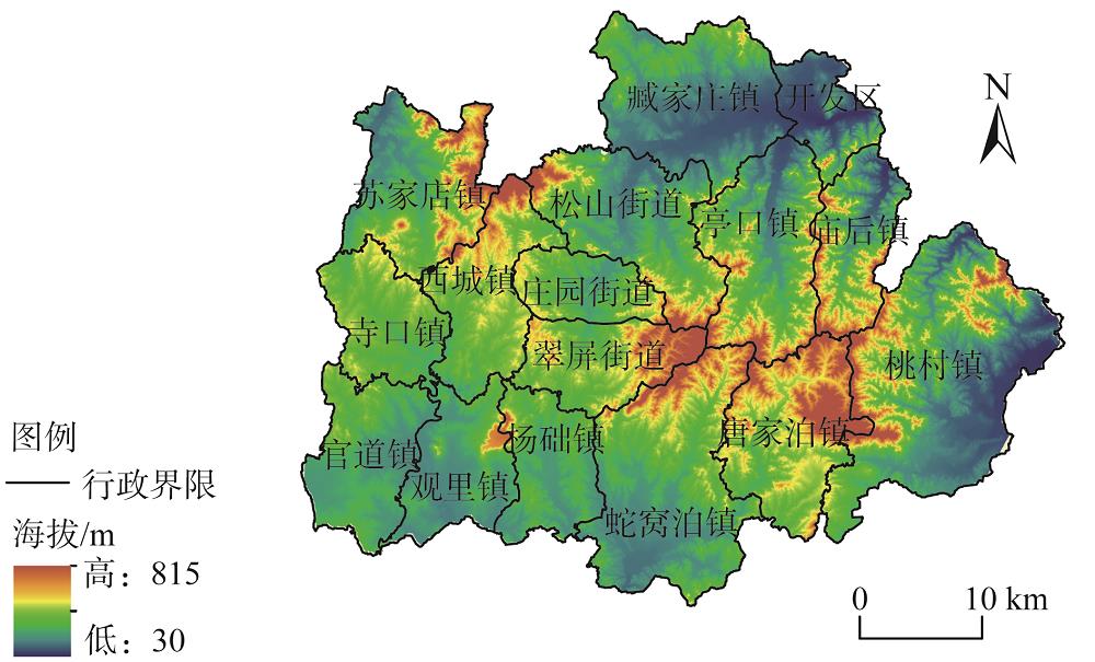
    Fig. 1. Administrative divisions and the digital elevation map of the study area
    The land use map of Qixia city
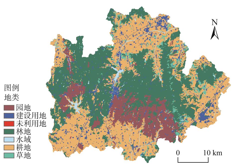
    Fig. 2. The land use map of Qixia city
    The distribution map of river basins and sampling points in Qixia city
    Fig. 3. The distribution map of river basins and sampling points in Qixia city
    The PCA ranking of landscape index at landscape and type levels on small watershed scale
    Fig. 4. The PCA ranking of landscape index at landscape and type levels on small watershed scale
    The PCA ranking of NPSP during normal and wet periods on small watershed scale in Qixia city
    Fig. 5. The PCA ranking of NPSP during normal and wet periods on small watershed scale in Qixia city
    The CCA between landscape index and NPSP on small watershed scale during normal period
    Fig. 6. The CCA between landscape index and NPSP on small watershed scale during normal period
    The CCA between landscape index and NPSP on small watershed scale during wet period
    Fig. 7. The CCA between landscape index and NPSP on small watershed scale during wet period
    河岸带小流域编号主要土地利用类型及面积比例/%
    白洋河1、2、3、4、5耕地:37.3、林地:24.1、建设用地:20.8
    黄水河6林地:37.2、耕地:26.3、园地:13.9
    漩河7、8、9、10、11耕地:35.7、林地:27.9、园地:19.2
    杨础河12、13耕地:43.2、园地:18.3、林地:10.0
    清水河14、15、16、17园地:38.0、耕地:25.8
    清阳河18、19、20、21林地:30.9、耕地:28.6、建设用地:23.3
    Table 1. The main river channels and land use type of different small watersheds in Qixia city
    相关性平水期丰水期
    TNTPCODNH4+-NECTNTPCODNH4+-NEC
    PD-0.400*0.293-0.349-0.053-0.878*0.2470.213-0.5360.254-0.869*
    ED-0.4440.304-0.252-0.144-0.909*0.1290.356-0.5960.417-0.928**
    LSI-0.187-0.02-0.686-0.376-0.7530.637-0.228-0.661-0.17-0.692
    CONTAG0.634*-0.364-0.0810.6620.7650.478*-0.5960.64-0.5050.755
    SHDI-0.394*0.1660.318-0.711-0.209-0.35*0.481-0.3350.352-0.203
    AI0.431-0.2920.2590.1240.909-0.138-0.3510.6-0.4040.929**
    AGRL0.475-0.201-0.1490.734*0.5060.217-0.5110.551-0.4230.507
    FRST-0.532*0.356-0.167-0.126-0.967**0.0880.462-0.6720.295-0.948**
    ORCD0.279-0.393-0.1180.407-0.4080.1040.291-0.5970.154-0.547
    URBN-0.4730.6130.004-0.3870.049-0.101-0.1590.510.2380.144
    PAST-0.190.1390.287-0.5790.389-0.233-0.0340.256-0.1330.486
    Table 2. The correlation between landscape pattern/land use type and NPSP in main river basins in Qixia city during normal and wet periods
    Meng-wen WANG, Wei QI, Peng-tao WANG, Zhuo-ran WANG. Relationship of landscape pattern and non-point source pollution in mountainous area of Eastern Shandong province[J]. Journal of Natural Resources, 2020, 35(12): 3007
    Download Citation