Hongyan ZHANG1,1,*, Chenghu ZHOU2,2,3,3, Guonian LV4,4, Zhifeng WU5,5..., Feng LU2,2,3,3, Jinfeng WANG2,2,3,3, Tianxiang YUE2,2,3,3, Jiancheng LUO3,3,6,6, Yong GE2,2,3,3 and Chengzhi QIN2,2,3,3|Show fewer author(s)
Author Affiliations
1School of Geographical Sciences, Northeast Normal University, Changchun 130024, China1东北师范大学地理科学学院,长春 1300242State Key Laboratory of Resources and Environmental Information System, Institute of Geographic Sciences and Natural Resources Research, Chinese Academy of Sciences, Beijing 100101, China2中国科学院地理科学与资源研究所 资源与环境信息系统国家重点实验室,北京 1001013University of Chinese Academy of Sciences, Beijing 100049, China3中国科学院大学,北京 1000494Key Laboratory of Virtual Geographic Environment, Ministry of Education, Nanjing Normal University, Nanjing 210023, China4虚拟地理环境教育部重点实验室(南京师范大学 ),南京 2100235School of Geographical Sciences, Guangzhou University, Guangzhou 510006, China5广州大学地理科学学院,广州 5100066State Key Laboratory of Remote Sensing Science, Aerospace Information Research Institute, Chinese Academy of Sciences, Beijing 100101, China6中国科学院空天信息创新研究院 遥感科学国家重点实验室,北京 100101show less
DOI: 10.12082/dqxxkx.2020.200167
Cite this Article
Hongyan ZHANG, Chenghu ZHOU, Guonian LV, Zhifeng WU, Feng LU, Jinfeng WANG, Tianxiang YUE, Jiancheng LUO, Yong GE, Chengzhi QIN. The Connotation and Inheritance of Geo-information Tupu[J]. Journal of Geo-information Science, 2020, 22(4): 653
Copy Citation Text
show less
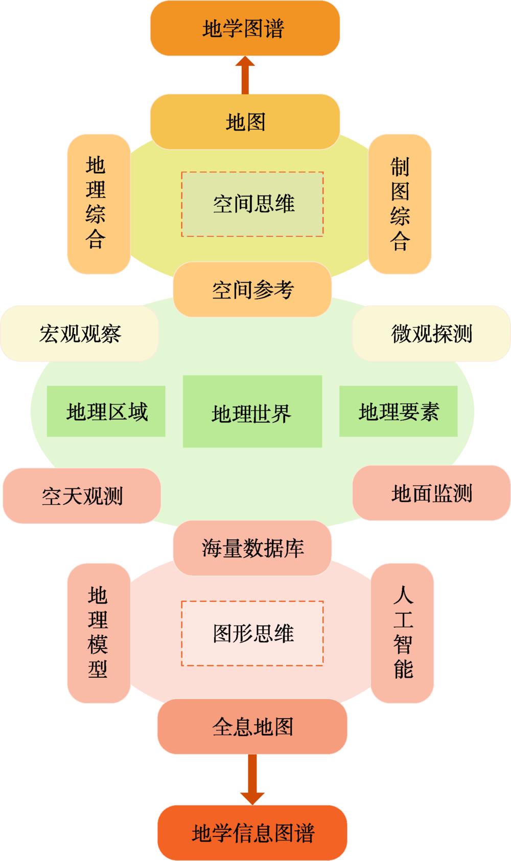
Fig. 1. The relationship between geo-science Tupu and geo-information Tupu
Fig. 2. A combined table of legend for landscape types map of East-west Dongting Mountain, Tai Hu
[4] | 序号 | 论文题目 | 完成时间 | 主要内容 | 出处 |
|---|
| 1 | 遵义附近的相对地势[2] | 1947年 | 自然与人文相统一,将地理区域研究视为具有“经络”的“地理之生命”的思想 | 《地学的探索》第一卷,地理学[9] | | 2 | 螳螂川流域之地文与人生[3] | 1947年 | | 3 | 大比例尺景观制图方法及其试验[4] | 1958年 | 以宏观理论指导微观分析,以微观机理论述宏观演化,以图形思维综合制图 | | 4 | 自然区划方法与制图实践[5] | 1963年 | | 5 | 《中国地形鸟瞰图集》的编制[6] | 1955年 | 以图形思维系统思考,运用系列地图方式将定性、定量化表达地理学宏观规律 | 《地学的探索》第二卷,地图学[10] | | 6 | 设计《中华人民共和国大地图集》的初步意见[7] | 1956年 | | 7 | “数字地球”战略及其制高点[8] | 1999年 | 通过地球信息科学将全球变化科学、对地观测技术和数字化空间服务有机统一起来 | 《地学的探索》第六卷,地球信息科学[11] |
|
Table 1. The representative works of Chen Shupeng's geo-information Tupu

![A combined table of legend for landscape types map of East-west Dongting Mountain, Tai Hu[4]](/richHtml/dqxxkxxb/2020/22/4/04000653/img_2.png)


