• Journal of Natural Resources
  • Vol. 35, Issue 1, 190 (2020)
Ying FANG, Jing WANG*, Long-yang HUANG, and Tian-lin ZHAI
Author Affiliations
  • School of Resource and Environmental Sciences, Wuhan University, Wuhan 430079, China
  • show less
    DOI: 10.31497/zrzyxb.20200116 Cite this Article
    Ying FANG, Jing WANG, Long-yang HUANG, Tian-lin ZHAI. Determining and identifying key areas of ecosystempreservation and restoration for territorial spatial planning based on ecological security patterns: A case study of Yantai city[J]. Journal of Natural Resources, 2020, 35(1): 190 Copy Citation Text show less
    Spatial distribution of comprehensive habitat quality in Yantai city
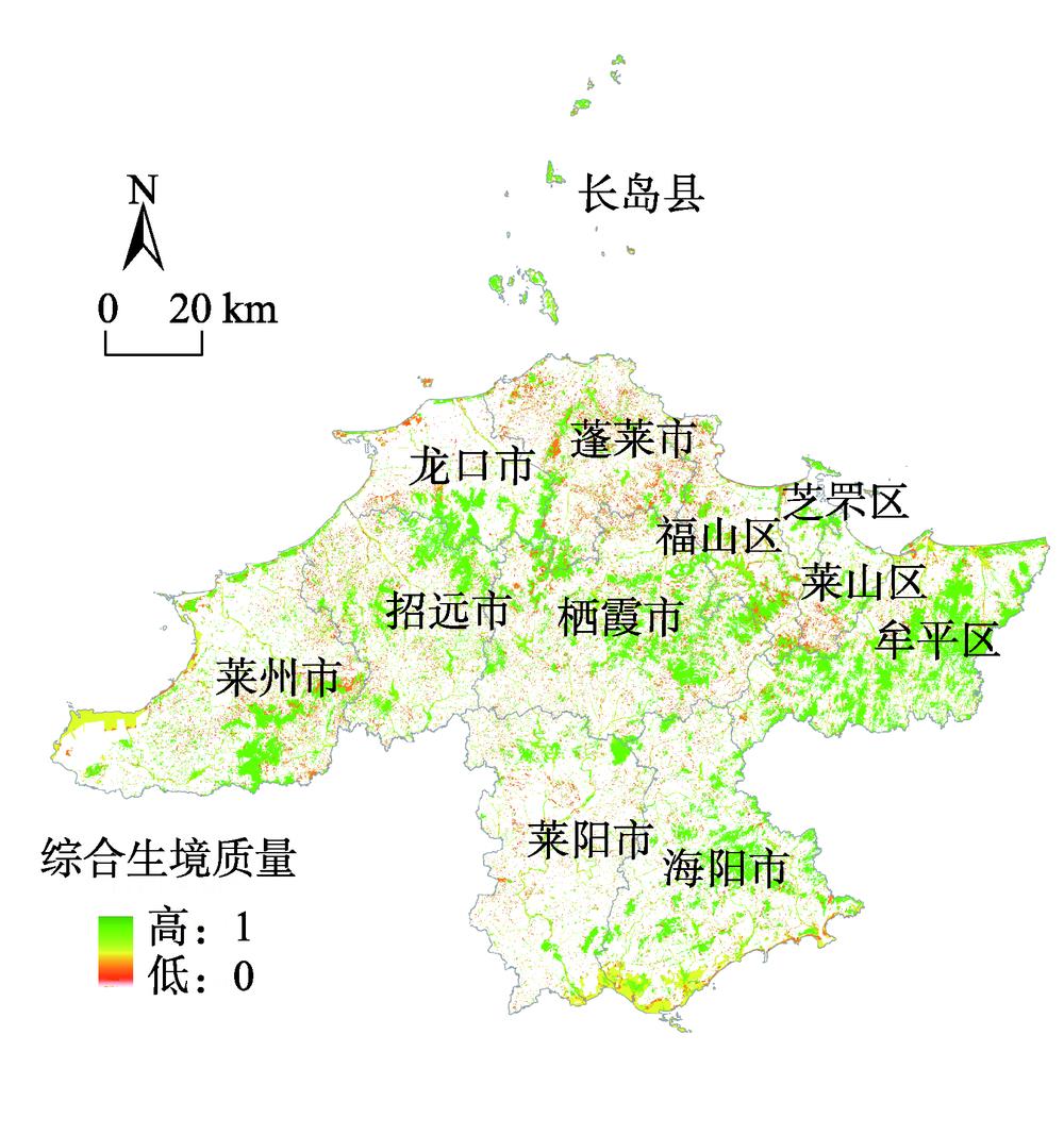
    Fig. 1. Spatial distribution of comprehensive habitat quality in Yantai city
    Landscape indices in Yantai city
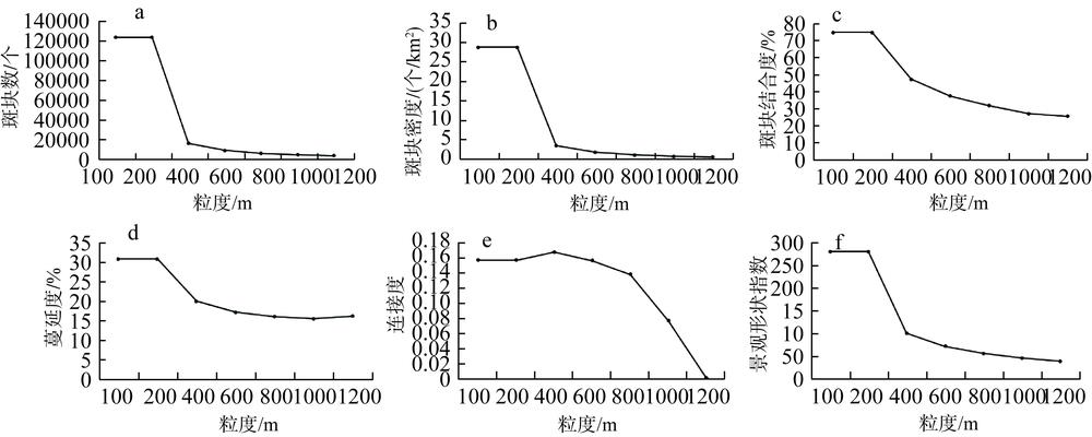
    Fig. 2. Landscape indices in Yantai city
    Spatial distribution of ecological hubs in Yantai city
    Fig. 3. Spatial distribution of ecological hubs in Yantai city
    Spatial distribution of basic ecological security pattern in Yantai city
    Fig. 4. Spatial distribution of basic ecological security pattern in Yantai city
    Spatial distribution of ecological pinch points to be remediated in Yantai city
    Fig. 5. Spatial distribution of ecological pinch points to be remediated in Yantai city
    Spatial distribution of ecological barrier points to be remediated in Yantai city
    Fig. 6. Spatial distribution of ecological barrier points to be remediated in Yantai city
    Spatial distribution of ecological break points to be remediated in Yantai city
    Fig. 7. Spatial distribution of ecological break points to be remediated in Yantai city
    Spatial distribution of fragmented ecological functional land in Yantai city
    Fig. 8. Spatial distribution of fragmented ecological functional land in Yantai city
    Spatial distribution of key areas of ecosystem preserva-tion and restoration for territoral spatial planing in Yantai city
    Fig. 9. Spatial distribution of key areas of ecosystem preserva-tion and restoration for territoral spatial planing in Yantai city
    阻力因子权重指标阻力系数
    景观类型显性阻力0.40湿地、林地1
    水域10
    耕地、草地100
    风景名胜区200
    园地300
    村庄用地、农村道路600
    干线公路700
    水利设施用地800
    城镇工矿建设用地1000
    其他用地500
    隐性阻力0.18Kriging 插值
    地貌因子坡度0.21<8°1
    8~15°10
    15~25°50
    25~35°75
    >35°100
    起伏度0.21<25°1
    25~50°10
    50~70°50
    70~100°75
    >100°100
    Table 1. Weights and coefficients of comprehensive ecological resistance surface
    修复区域土地利用现状具体分布建议修复方向
    生态“夹点”区域河流莱阳市五龙河城厢街道、古柳街道、姜疃镇河段,富水河山前店镇河段河流污染治理、清淤;建立河流保护区;河流违法监督
    福山区清洋河清扬街道河段
    海阳市东村河凤城街道河段
    莱山区辛安河解甲庄街道河段
    招远市界河辛庄镇与黄山馆镇交界河段,城子水库支流毕郭镇河段
    莱州市沙河长胜村至于家村河段,王河平里店镇河段
    栖霞市清水河蛇窝泊镇河段,龙门口水库支流官道镇河段
    高尔夫球场莱山区马山寨高尔夫俱乐部整治清理、控制污染物排放
    港口招远市海北咀村渔港生态污染治理;控制发展规模,减少生活和生产污染
    生态障碍点区域城镇建设用地芝罘区中部城市绿地建设、提高植被丰度;
    退耕还林、退耕还湖
    城镇建设用地、耕地、其他用地莱州市西北部
    耕地栖霞市南部
    耕地莱阳市北部
    生态断裂点区域铁路23处廊道—铁路交叉点建立管状涵洞、桥下涵洞、“过街天桥”等野生动物通道;竖立警示牌;开展野生动物通道监测
    高速公路19处廊道—高速公路交叉点
    破碎生态空间生态用地地形修复、岸线维护;实行异地复绿工程
    Table 2. Key areas of ecosystem preservation and restoration for territorial spatial planning in Yantai city
    Ying FANG, Jing WANG, Long-yang HUANG, Tian-lin ZHAI. Determining and identifying key areas of ecosystempreservation and restoration for territorial spatial planning based on ecological security patterns: A case study of Yantai city[J]. Journal of Natural Resources, 2020, 35(1): 190
    Download Citation