Luqi LI1,1,1,1,1,1,1,1,1,1, Qiyan WU1,1,1,1,1,1,1,1,1,1, Kewen LIU1,1,1,1,1,1,1,1,1,1, Shuangbo LIANG1,1,1,1,1,1,1,1,1,1,1,1,1,1,1,1,1,1,1,1, and Chaofeng QIAN1,1,1,1,1,1,1,1,1,1
Author Affiliations
11
School of Urban and Regional Science, East China Normal University, Shanghai 200241, China11
华东师范大学城市与区域科学学院,上海 20024112
School of Public Policy and Administration, Xi’an Jiaotong University, Xi’an 710049, China12
西安交通大学公共政策与管理学院,西安 71004913
School of Tourism and Urban-rural Planning, Zhejiang Gongshang University, Hangzhou 310018, China13
浙江工商大学旅游与城乡规划学院,杭州 31001814
Key Laboratory of Watershed Geographic Sciences, CAS, Nanjing 210008, China14
中国科学院流域地理学重点实验室,南京 21000815
Nanjing Institute of Geography and Limnology, CAS, Nanjing 210008, China15
中国科学院南京地理与湖泊研究所,南京 210008show less
Abstract
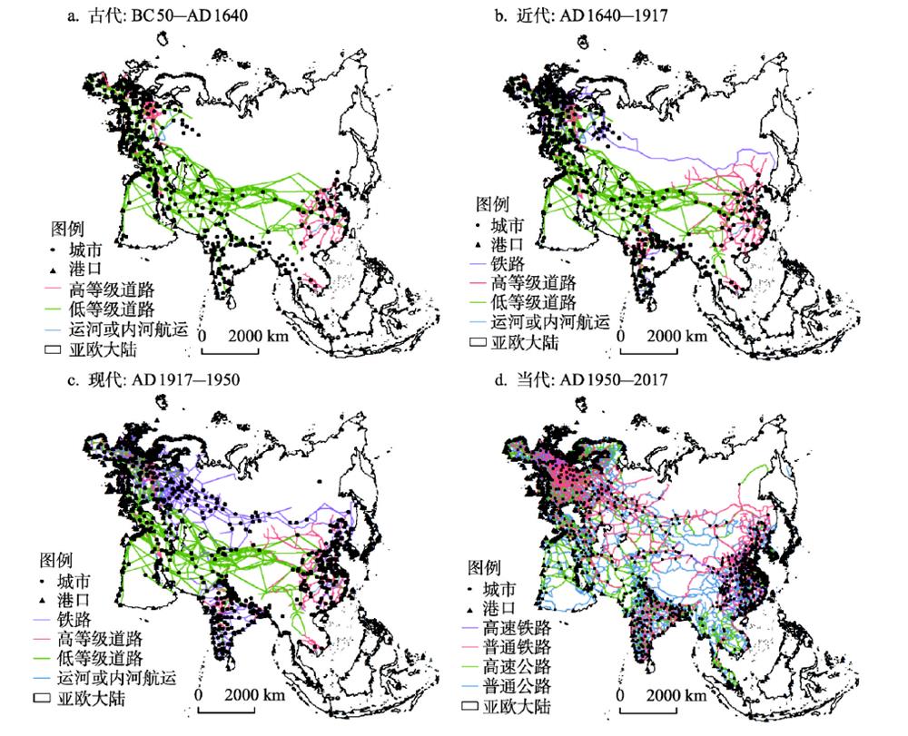
The Eurasian continent is the center of the world political arena and plays a vital role in the shifting geopolitical orders in human history. Moreover, it is the main area where the Belt and Road Initiative deploys. Relevant studies of the initiative focus more on synchronic analysis and less on the long-term evolution of land and sea transport patterns. Therefore, the goal of this paper is to conduct a preliminary analysis on the spatial evolution of Eurasian land and sea transport based on four periods including ancient period (BC 50-AD 1640), early modern period (AD 1640-1917), late modern period (AD 1917-1950) and contemporary times (AD 1950-2017). In this way, the historical role and strategic deployment of the Belt and Road Initiative could be further uncovered. Study shows that the degree of connectivity in various regions has steadily increased since the early modern times. And the accessibility tends to be equalized at the continental scale, while the land and sea transport networks both show a trend of polarization at the sub-continental scale, with a range of key hubs becoming more prominent in coordinating the flows among different areas. Furthermore, transport lines with strategic importance have significant influence on the accessibility of different areas as well as the geopolitical order of the continent. According to the result, the significance of the Belt and Road Initiative should be understood on a much longer time scale. Meanwhile, decentralized cooperative strategies should be promoted, existing key hubs should be made full use of, and a range or new hubs should further be developed. In addition, arteries such as the Eurasian High-Speed Railway should be constructed to promote the interconnection among various regions in Eurasia so as to gain a strategic advantage in the geopolitical arena. The innovation of this study is analyzing the evolution of Eurasian land and sea transport on a time scale of more than 2000 years.