Wen LIU1,1,2,2, Qingming ZHAN1,1,2,2,*, Quanyi LIU1,1,2,2, Yao SI3,3..., Qilei HUANG1,1,2,2 and Zhiyu FAN1,1,2,2|Show fewer author(s)
Author Affiliations
1School of Urban Design, Wuhan University, Wuhan 430072, China1武汉大学城市设计学院,武汉 4300722Digital City Research Center, Wuhan University, Wuhan 430072, China2武汉大学数字城市研究中心,武汉 4300723Wuhan Geomatics Institute, Wuhan 430022, China3武汉市测绘研究院,武汉 430022show less
DOI: 10.12082/dqxxkx.2020.190309
Cite this Article
Wen LIU, Qingming ZHAN, Quanyi LIU, Yao SI, Qilei HUANG, Zhiyu FAN. A Method for Association and Conversion between Geographical Condition Monitoring Data and Urban Planning Land Use Data[J]. Journal of Geo-information Science, 2020, 22(2): 161
Copy Citation Text
show less
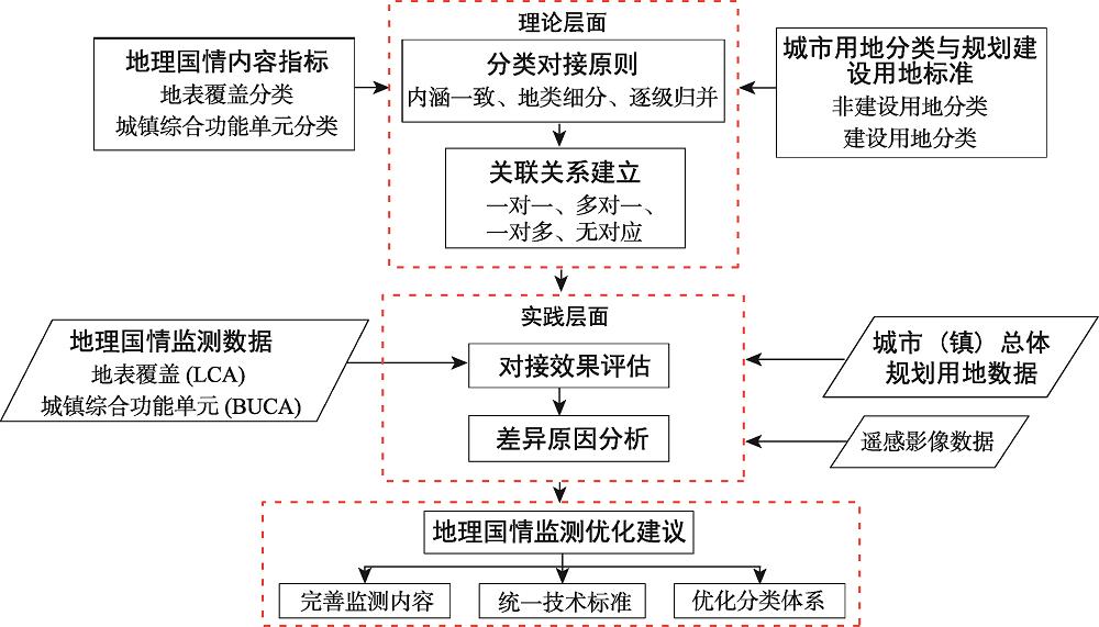
Fig. 1. Overall framework for association and conversion between geographical condition monitoring data and land use data for urban master planning
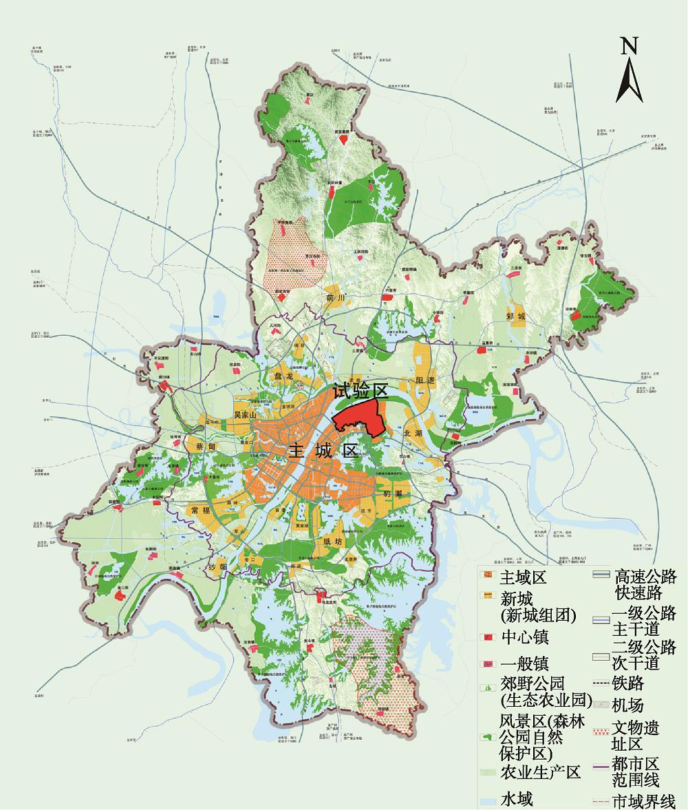
Fig. 2. Location of the experimental area in Wuhan City
Fig. 3. Land cover, urban comprehensive functional unit, and land use of urban master planning in the experimental area
Fig. 4. Consistency between the geographical condition monitoring data and the class I data of urban development land in Wuhan
Fig. 5. Consistency between the geographical condition monitoring data and the class II data of urban development land in Wuhan
Fig. 6. Differences between the geographical condition monitoring data and the urban development land data
| 类别 | 地理国情内容指标 | 规划用地分类体系 |
|---|
| 工作目标 | 制定背景 | 为全面掌握我国自然和人文地理国情信息,服务于防灾减灾、应急保障及相关行业调查统计等工作 | 为城乡统筹与城市规划及管理提供依据 | | 关注重点 | 侧重反映国土资源要素的自然状态和现状特征 | 侧重反映土地的主要使用功能或规划用途,尤其是建设用地的现状建设状态与功能性质 | | 技术指标 | 数据来源 | 遥感影像为基础,辅以人口统计、社会经济及各专项调查 | 遥感影像、规划用地许可和建筑工程许可等审批信息 | | 数据精度 | 耕地、园地、水域、其他地区林地和草地一般为400 m2,大面积林区、草原地区、房屋建筑区、人工堆掘地为1600 m2,绿化林地、绿化草地、独立房屋建筑为200 m2,荒漠地区为10 000 m2;居住小区为5000 m2,休闲娱乐景区为50 000 m2,体育活动场所、名胜古迹、宗教场所为10 000 m2 | 非建设用地分类:耕地、园地为600 m2,林地、草地等其他地类为1500 m2等建设用地分类:无最小上图面积 | | 数学基础 | 2000国家大地坐标系,1985国家高程基准 | 1954北京坐标系,1985国家高程基准 | | 分类标准 | 构成内容 | 包括地表覆盖、地理国情要素、地表形态3个方面,采用三级分类体系,形成12一级类,58二级类,135三级类 | 包括城乡用地分类与城市建设用地两部分,采用三级分类体系,前者2大类、9中类、14小类,后者8大类、35中类、42小类 | | 分类对象 | 采用要素模型来描述,分为点、线、面、体4种 | 采用面状要素来描述 |
|
Table 1. Differences between the geographical condition classification and the land use classification for urban master planning
| 城乡用地分类 | 地理国情内容指标 |
|---|
| 大类 | 中类 |
|---|
| 建设用地 | 城乡居民点建设用地(H1) | 地表覆盖:房屋建筑区(0500)、绿化林地(0360)、人工草地(0420)、硬化地表(0710)、城墙(0740)、固化池(0760)、工业设施(0770)、其他构筑物(0790)、垃圾堆放物(0822)、其他堆放物(0829)、建筑工地(0830)地理国情要素:城镇综合功能单元(1140) | | 区域交通设施用地(H2) | 地表覆盖:护坡灌草(0424)、停机坪与跑道(0714)、硬化护坡(0715)、道路建筑工地(0833)地理国情要素:单位院落(1143) | | 区域公用设施用地(H3) | 地表覆盖:堤坝(0721)、沙障(0780)、垃圾堆放物(0822)地理国情要素:城镇综合功能单元中的工矿企业(1142)、单位院落(1143) | | 特殊用地(H4) | — | | 采矿用地(H5) | 地表覆盖:晒盐地(0763)、露天采掘场(0810)、尾矿堆放物(0821) | | 其他建设用地(H9) | 地表覆盖:建筑工地(0830)、其他人工堆掘地(0890) | | 非建设用地 | 水域(E1) | 地表覆盖:水面(1001)、水渠(1012)、冰川与常年积雪(1050)地理国情要素:水域(1000) | | 农林用地(E2) | 地表覆盖:耕地(0110-0120)、园地(0130-0190)、林地(0310-0380)、牧草地(03A1)、场院(0716)、温室大棚(0750) | | 其他非建设用地(E9) | 地表覆盖:荒漠与裸露地(0900)、固沙灌草(03A3)、护坡灌草(03A4) |
|
Table 2. Corresponding relationships between the geographical condition classification and the urban-rural land classification in Wuhan
| 城市建设用地分类 | | 地理国情内容指标 |
|---|
| 大类 | 中类 | | 城镇综合功能单元分类 | 地表覆盖分类 | | 居住用地(R) | | | 居住小区(1141) | 人工堆掘地(0800)等 | | 公共管理与公共服务用地(A) | 行政办公用地(A1) | | 行政办公(114A) | 露天体育场(0712)、城墙(0740)、游泳池(0761)等 | | 文化设施用地(A2) | | 文化设施(114B) | | | 教育科研用地(A3) | | 教育科研(114C) | | | 体育用地(A4) | | 体育活动场所(1145) | | | 医疗卫生用地(A5) | | 医疗卫生(114D) | | | 社会福利设施用地(A6) | | 社会福利(114E) | | | 文物古迹用地(A7) | | 名胜古迹(1146) | | | 外事用地(A8) | | — | | | 宗教用地(A9) | | 宗教场所(1147) | | | 商业服务业设施用地(B) | 商业设施用地(B1) | | 商业设施(114F) | 加油(气)充电站(0736)等 | | 商务设施用地(B2) | | 商务设施(114G) | | | 娱乐康体用地(B3) | | 娱乐康体(114H) | | | | | 体育活动场所(1145) | | | 公用设施营业网点用地(B4) | | 公用设施营业网点(114I) | | | 其他服务业用地(B9) | | — | | | 工业用地(M) | | | 工矿企业(1142) | 污水处理池(0762)、晒盐池(0763)、其他固化池(0769)、工业设施(0770)等 | | 物流仓储用地(W) | | | 工矿企业(1142) | 露天堆放场(0717)等 | | 道路与交通设施用地(S) | 城市道路用地(S1) | | — | 道路(0600)、停车场(0713)、道路建筑工地(0833)等 | | 城市轨道交通用地(S2) | | — | | | 交通枢纽用地(S3) | | 交通设施(114K) | | | 交通场站用地(S4) | | 交通设施(114K) | | | 其他交通设施用地(S9) | | 交通设施(114K) | | | 公用设施用地(U) | | | 工矿企业(1142)、其他单位院落(114J) | 硬化护坡(0715)、堤坝(0721)、垃圾堆放物(0822)等 | | 绿地与广场用地(G) | 公园绿地(G1) | | 休闲娱乐景区(1144) | 绿化林地(0360)、人工草地(0420)、广场(0711)等 | | 防护绿地(G2) | | — | | | 广场用地(G3) | | 休闲娱乐景区(1144) | | | 生产绿地(G4) | | — | | | 其他绿地(G5) | | — | | | 待建用地(F) | | | — | 人工堆掘地(0800)等 |
|
Table 3. Corresponding relationship between the geographical condition classification and the urban development land classification in Wuhan