• Journal of Geo-information Science
  • Vol. 22, Issue 10, 1971 (2020)
Xuemiao WANG1、2, Qingyan MENG1、*, Shaohua ZHAO3, Juan LI1, Linlin ZHANG1、2, and Xu CHEN1、2
Author Affiliations
  • 1Aerospace Information Research Institute, Chinese Academy of Sciences, Beijing 100094, China
  • 2University of Chinese Academy of Sciences, Beijing 100049, China
  • 3State Environmental Protection Key Lab of Satellite Remote Sensing, Ministry of Ecology and Environment Center for Satellite Application on Ecology and Environment, Beijing 100094, China
  • show less
    DOI: 10.12082/dqxxkx.2020.200122 Cite this Article
    Xuemiao WANG, Qingyan MENG, Shaohua ZHAO, Juan LI, Linlin ZHANG, Xu CHEN. Urban Green Space Classification and Landscape Pattern Measurement based onGF-2 Image[J]. Journal of Geo-information Science, 2020, 22(10): 1971 Copy Citation Text show less
    Study area location and remote sensing image
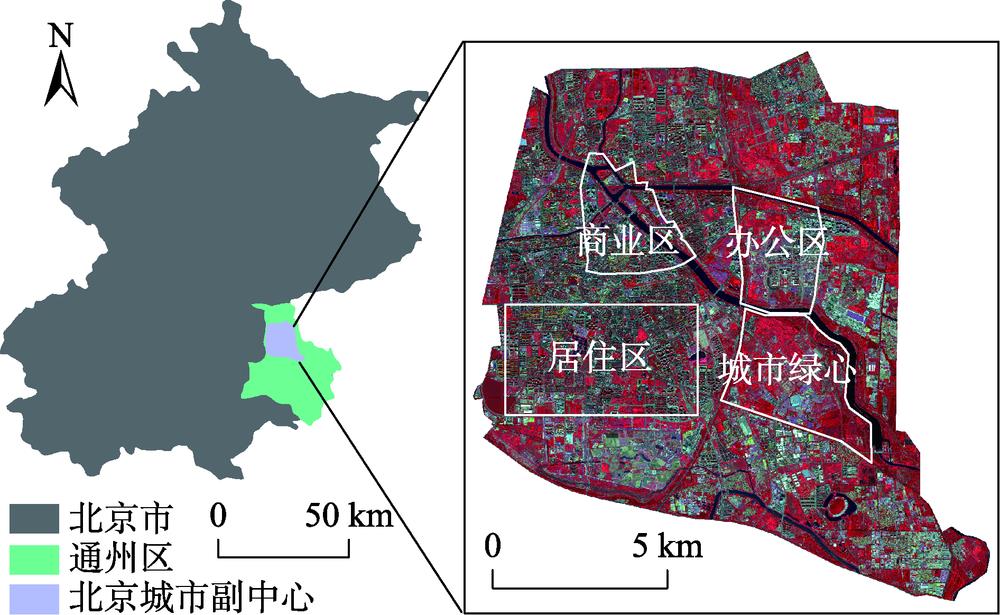
    Fig. 1. Study area location and remote sensing image
    Characteristics of different types of vegetation in summer and winter
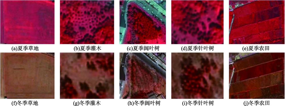
    Fig. 2. Characteristics of different types of vegetation in summer and winter
    The technical route of this study
    Fig. 3. The technical route of this study
    Diagram of moving window method
    Fig. 4. Diagram of moving window method
    Importance of summer and winter image features
    Fig. 5. Importance of summer and winter image features
    Importance of multi-temporal image features
    Fig. 6. Importance of multi-temporal image features
    Urban vegetation classification map of Beijing Vice-City Center in 2018
    Fig. 7. Urban vegetation classification map of Beijing Vice-City Center in 2018
    Calculation results of green space landscape metrics of Beijing Vice-City Center in 2018(class level)
    Fig. 8. Calculation results of green space landscape metrics of Beijing Vice-City Center in 2018(class level)
    [in Chinese]
    Fig. 9. [in Chinese]
    UGI and SHDI distribution map of study area
    Fig. 10. UGI and SHDI distribution map of study area
    特征个数夏季单时相冬季单时相多时相
    572.454.074.4
    1072.658.885.7
    1577.559.387.0
    2077.561.787.7
    2577.562.187.2
    3078.363.487.0
    35--85.7
    40--87.0
    Table 1. Overall classification accuracy obtained by using different number of features (%)
    夏季冬季多时相
    PAUAPAUAPAUA
    阔叶树0.740.800.650.490.890.89
    针叶树0.730.810.940.760.900.92
    农田0.630.680.760.600.690.82
    草地0.920.860.620.790.930.88
    灌木0.900.750.140.500.970.86
    Table 2. Classification accuracy of urban vegetation classif-ication using summer, winter and multi-temporal image
    PLAND/%PD/(个/100ha)ED/(m/ha)FRACSHDIAI
    城市绿心65.012677.050701.8491.2521.50495.395
    居住区38.0981612.312689.8391.2491.41593.600
    办公区37.060784.271668.8511.2501.39695.096
    商业区26.9071833.961720.0511.2511.33193.364
    研究区43.8051008.982673.2261.2521.48594.758
    Table 3. Calculation results of green space landscape metrics of Beijing Vice-City Center in 2018 (landscape level)
    Xuemiao WANG, Qingyan MENG, Shaohua ZHAO, Juan LI, Linlin ZHANG, Xu CHEN. Urban Green Space Classification and Landscape Pattern Measurement based onGF-2 Image[J]. Journal of Geo-information Science, 2020, 22(10): 1971
    Download Citation