[1] 陈述彭. 地学的探索第一卷,地理学[M]. 北京: 科学出版社, 1990. [ ChenS P. Probe into Geo-science, Volume I,Geography[M]. Beijing: Science Press, 1990. ] [ Chen S P. Probe into Geo-science, Volume I,Geography[M]. Beijing: Science Press, 1990. ]
[2] 陈述彭. 地学的探索第二卷,地图学[M]. 北京: 科学出版社. 1990. [ ChenS P. Probe into Geo-science, Volume II,Cartogrphy[M]. Beijing: Science Press, 1990. ] [ Chen S P. Probe into Geo-science, Volume II,Cartogrphy[M]. Beijing: Science Press, 1990. ]
[3] 陈述彭. 地学的探索第三卷,遥感应用[M]. 北京: 科学出版社, 1990. [ ChenS P. Probe into Geo-science, Volume III, Remote sensing application[M]. Beijing: Science Press, 1990. ] [ Chen S P. Probe into Geo-science, Volume III, Remote sensing application[M]. Beijing: Science Press, 1990. ]
[4] 陈述彭. 地学的探索第五卷,城市化区域发展[M]. 北京, 科学出版社, 2003. [ ChenS P. Probe into Geo-science,Volume V, Urbanization and regional development[M]. Beijing: Science Press, 2003. ] [ Chen S P. Probe into Geo-science,Volume V, Urbanization and regional development[M].Beijing: Science Press, 2003. ]
[5] 陈述彭, 周成虎, 陆锋. 季风热带与亚热带地区的遥感应用实验[J]. 地球信息科学, 2005,7(4):2-4. [ ChenS P, ZhouC H, LuF. Several remote sensing experiments in monsoon tropical and subtropical regions[J]. Geo-information Science, 2005,7(4):2-4. ] [ Chen S P, Zhou C H, Lu F. Several remote sensing experiments in monsoon tropical and subtropical regions[J]. Geo-information Science, 2005,7(4):2-4. ]
[6] 陈述彭. 新经济时代的西部开发[J]. 地球信息科学, 2001,3(1):2-8. [ ChenS P. Western development in new economic era[J]. Geo-information Science, 2001,3(1):2-8. ] [ Chen S P. Western development in new economic era[J]. Geo-information Science, 2001,3(1):2-8. ]
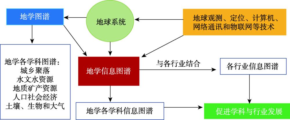
[7] 陈述彭. 地学信息图谱刍议[J]. 地理研究, 1998,17(suppl.):5-8. [ ChenS P. On the map of geo-science information[J]. Geographical Research, 1998,17(suppl.):5-8. ] [ Chen S P. On the map of geo-science information[J]. Geographical Research, 1998,17(suppl.):5-8. ]
[8] 陈述彭. 地学的探索第六卷,地球信息科学[M]. 北京: 科学出版社, 2003. [ ChenS P. Probe into Geo-science,Volume V, Geo-information Science[M]. Beijing: Science Press, 2003. ] [ Chen S P. Probe into Geo-science,Volume V, Geo-information Science[M]. Beijing: Science Press, 2003. ]
[9] 陈述彭. 历史轨迹与知识创新[J]. 地理学报, 2001,56(suppl.):1-7. [ ChenS P. Along the historical way up to knowledge innovation[J]. Acta Geographica Sinica, 2001,56(suppl.):1-7. ] [ Chen S P. Along the historical way up to knowledge innovation[J]. Acta Geographica Sinica, 2001, 56(suppl.):1-7. ]
[10] 陈述彭, 岳天祥, 励惠国. 地学信息图谱研究及其应用[J]. 地理研究, 2000,19(4):337-343. [ ChenS P, YueT X, LiH G. Studies on geo-information Tupu and its application[J]. Geographical Research, 2000,19(4):337-343. ] [ Chen S P, Yue T X, Li H G. Studies on geo-information Tupu and its application[J]. Geographical Research, 2000,19(4):337-343. ]
[11] 陈述彭, 陈秋晓, 周成虎. 网格地图与网格计算[J]. 测绘科学, 2002,27(4):1-6,2. [ ChenS P, ChenQ X, ZhouC H. Grid mapping and grid computing[J]. Science of Surveying and Mapping, 2002,27(4):1-62. ] [ Chen S P, Chen Q X, Zhou C H. Grid mapping and grid computing[J]. Science of Surveying and Mapping, 2002,27(4):1-62. ]
[12] 杨存建, 徐美, 黄朝永. 遥感信息机理的水体提取方法的探讨[J]. 地理研究, 1998,17(suppl.):86-89. [ YangC J, XuM, HuangC Y. Discussion on water extraction method of remote sensing information mechanism[J]. Geographical Research, 1998,17(suppl.):86-89. ] [ Yang C J, Xu M, Huang C Y. Discussion on water extraction method of remote sensing information mechanism[J]. Geographical Research, 1998,17(suppl.):86-89. ]
[13] 杨存建, 周成虎. TM影像的居民地信息提取方法研究[J]. 遥感学报, 2000,4(2):146-150,166. [ YangC J, ZhouC H. Extracting residential areas on the TM imagery[J]. Journal of Remote Sensing, 2000,4(2):146-150,166. ] [ Yang C J, Zhou C H. Extracting residential areas on the TM imagery[J]. Journal of Remote Sensing, 2000,4(2):146-150,166. ]
[14] 杨存建, 周成虎. 基于知识发现的TM图像居民地自动提取研究[J]. 遥感技术与应用, 2001,16(1):1-6. [ YangC J, ZhouC H. Extracting residential area from TM image on the basis of knowledge discovered[J]. Remote Sensing Technology and Application, 2001,16(1):1-6. ] [ Yang C J, Zhou C H. Extracting residential area from TM image on the basis of knowledge discovered[J]. Remote Sensing Technology and Application, 2001,16(1):1-6. ]
[15] 杨存建, 赵梓健, 倪静, 等. 基于MODIS数据的川西积雪时空变化分析[J]. 中国科学:地球科学, 2011,41(12):1743-1750. [ YangC J, ZhaoZ J, NiJ, RenX L, et al. Temporal and spatial analysis of changes in snow cover in western Sichuan based on MODIS images[J]. Scientia Sinica(Terrae), 2011,41(12):1743-1750. ] [ Yang C J, Zhao Z J, Ni J, Ren X L, et al. Temporal and spatial analysis of changes in snow cover in western Sichuan based on MODIS images[J]. Scientia Sinica(Terrae), 2011,41(12):1743-1750. ]
[16] 杨存建, 赵梓健, 任小兰, 等. 基于遥感和GIS的川西绿被时空变化研究[J]. 生态学报, 2012,32(2):632-640. [ YangC J, ZhaoZ J, RenX L, et al. The analysis of the green vegetation cover change in western Sichuan based on GIS and Remote sensing[J]. Acta Ecologica Sinica, 2012,32(2):632-640. ] [ Yang C J, Zhao Z J, Ren X L,et al. The analysis of the green vegetation cover change in western Sichuan based on GIS and Remote sensing[J]. Acta Ecologica Sinica, 2012,32(2):632-640. ]
[17] 杨存建, 周其林, 任小兰, 等. 基于多时相MODIS数据的四川省森林植被类型信息提取[J]. 自然资源学报, 2014,29(03):507-515. [ YangC J, ZhouQ L, RenX L, et al. Extracting forest vegetation types from multi-temporal MODIS imagery in Sichuan province[J]. Journal of Natural Resources, 2014,29(3):507-515. ] [ Yang C J, Zhou Q L, Ren X L, et al. Extracting forest vegetation types from multi-temporal MODIS imagery in Sichuan province[J]. Journal of Natural Resources, 2014,29(3):507-515. ]
[18] 杨存建, 王琴, 牟琳, 等. 基于知识发现的QUICKBIRD影像乡村聚落单元信息提取技术:中国中国, ZL2010 1 0142931.7[P]. 2014-01-08. [ YangC J, WangQ, MouL, et al. Information extraction technology of rural settlement unit in QUICKBIRD Image based on knowledge discovery: China, ZL2010 1 0142931.7[P]. 2014-01-08. ] [ Yang C J, Wang Q, Mou L, et al. Information extraction technology of rural settlement unit in QUICKBIRD Image based on knowledge discovery: China, ZL2010 1 0142931.7[P]. 2014-01-08. ]
[19] 杨存建, 周成虎. 利用RADARSAT SWA SAR和LANDSAT TM的互补信息确定洪水水体范围[J]. 自然灾害学报, 2001,10(2):79-83. [ YangC J, ZhouC H. Application of complementary information RADARSAT SWA SAR and LANNDSAT TM in deciding the flood extent[J]. Journal of Natural Disasters, 2001,10(2):79-83. ] [ Yang C J, Zhou C H. Application of complementary information RADARSAT SWA SAR and LANNDSAT TM in deciding the flood extent[J]. Journal of Natural Disasters, 2001,10(2):79-83. ]
[20] et al基于DEM的SAR图像洪水水体的提取[J]. 自然灾害学报, 11, 121-125(2002).
[21] et al高分辨率影像城市植被自动提取算法[J]. 地球信息科学学报, 18, 248-254(2016).
[22] 李德仁, 张良培, 夏桂松. 遥感大数据自动分析与数据挖掘[J]. 测绘学报, 2014,43(12):1211-1216. [ LiD R, ZhangL P, XiaG S. Automatic analysis and mining of remote sensing big data[J]. Acta Geodaeticaet Cartographica Sinica, 2014,43(12):1211-1216. ] [ Li D R, Zhang L P, Xia G S. Automatic analysis and mining of remote sensing big data[J]. Acta Geodaeticaet Cartographica Sinica, 2014,43(12):1211-1216. ]
[23] 李霞, 徐涵秋, 李晶, 等. 基于NDSI和NDISI指数的SPOT-5影像裸土信息提取[J]. 地球信息科学学报, 2016,18(1):117-123. [ LiX, XuH Q, LiJ, et al. Extraction of bare soil features from SPOT-5 imagery based on NDSI and NDISI. Journal of Geo-informationScience, 2016,18(1):117-123. ] [ Li X, Xu H Q, Li J, et al. Extraction of bare soil features from SPOT-5 imagery based on NDSI and NDISI. Journal of Geo-information Science, 2016,18(1):117-123. ]
[24] 杨存建, 王琴, 倪静, 等. 多源数据协同的精细森林植被类型信息遥感更新方法:中国, ZL 2010 10275450.3)[P]. 2013-10-08. [ YangC J, WangQ, NiJ, et al. Remote sensing updating method of fine forest vegetation type information based on multi-source data: China, ZL 2010 10275450.3)[P]. 2013-10-08. ] [ Yang C J, Wang Q, Ni J, et al. Remote sensing updating method of fine forest vegetation type information based on multi-source data: China, ZL 2010 10275450.3)[P]. 2013-10-08. ]
[25] et al多源时空数据协同的高精度土地利用遥感更新技术[P]. 中国,获授权日期:2014.5.14.
[26] 杨存建, 刘纪远, 张增祥, 等. 遥感和GIS支持下的云南省退耕还林还草决策分析[J]. 地理学报, 2001,56(2):181-188. [ YangC J, LiuJ Y, ZhangZ X, et al. Decision on afforesting and regrassing some of the dry sloping cultivated with support of GIS and remote sensing in yunnan[J]. Acta Geographica Sinica, 2001,56(2):181-188. ] [ Yang C J, Liu J Y, Zhang Z X, et al. Decision on afforesting and regrassing some of the dry sloping cultivated with support of GIS and remote sensing in yunnan[J]. Acta Geographica Sinica, 2001,56(2):181-188. ]
[27] et al遥感和GIS支持下的中国退耕还林还草决策分析[J]. 遥感学报, 6, 205-211(2002).
[28] 杨存建, 冯凉, 徐育建, 等. 基于ARCGIS的四川省分级退耕还林还草空间决策分析[J]. 自然资源学报, 2007,22(6):986-993. [ YangC J, FengL, XuY J, et al. Decision on gradually reforesting and regrassing some of the dry land based on ArcGIS in Sichuan province[J]. Journal of Natural Resources, 2007,22(6):986-993. ] [ Yang C J, Feng L, Xu Y J, et al. Decision on gradually reforesting and regrassing some of the dry land based on ArcGIS in Sichuan province[J]. Journal of Natural Resources, 2007,22(6):986-993. ]
[29] 杨存建, 冯凉, 杨洪忠, 等. 四川省林草火险等级评价[J]. 地理研究, 2010,29(6):980-988. [ YangC J, FengL, YangH Z, et al. Study of evaluation of forest and grass fire risk grade in Sichuan Province[J]. Geographical Research, 2010,29(6):980-988. ] [ Yang C J, Feng L, Yang H Z, et al. Study of evaluation of forest and grass fire risk grade in Sichuan Province[J]. Geographical Research, 2010,29(6):980-988. ]
[30] 李春艳, 杨存建, 周其林, 等. 森林防火减灾信息系统的设计开发——以四川省遂宁市为例[J]. 地球信息科学学报, 2010,12(5):695-699. [ LiC Y, YangC J, ZhouQ L, et al. Study of Suining's forest fire prevention information system based on 3S[J]. Journal of Geo-information Science, 2010,12(5):695-699. ] [ Li C Y, Yang C J, Zhou Q L, et al. Study of Suining's forest fire prevention information system based on 3S[J]. Journal of Geo-information Science, 2010,12(5):695-699. ]
[31] et al重大生态工程生态效益监测与评估研究[J]. 地球科学进展, 32, 1174-1182(2017).
[32] et al西南地区山洪灾害时空分布特征及其影响因素[J]. 地理学报, 74, 1374-1391(2019).
[33] [M]. 遥感地学分析(1990).
[34] 杨存建, 张果, 陈军, 等. 基于遥感的成都市及其周边城镇的扩展[J]. 地理研究, 2008,( 1):100-108. [ YangC J, ZhangG, ChenJ, et al. The research of the sprawl of Chengdu city and its peripheral towns by using remote sensing[J]. Geographical Research, 2008,( 1):100-108.] [ Yang C J, Zhang G, Chen J, et al. The research of the sprawl of Chengdu city and its peripheral towns by using remote sensing[J]. Geographical Research, 2008,(1):100-108.]
[35] 刘纪远, 宁佳, 匡文慧, 等. 2010-2015年中国土地利用变化的时空格局与新特征[J]. 地理学报, 2018,73(5):789-802. [ LiuJ Y, NingJ, KuangW H, et al. Spatio-temporal patterns and characteristics of land-use change in China during 2010-2015[J]. Acta Geographica Sinica, 2018,73(5):789-802.] [ Liu J Y, Ning J, Kuang W H, et al. Spatio-temporal patterns and characteristics of land-use change in China during 2010-2015[J]. Acta Geographica Sinica, 2018,73(5):789-802.]
[36] 程维明, 高晓雨, 马廷, 等. 基于地貌分区的1990-2015年中国耕地时空特征变化分析[J]. 地理学报, 2018,73(9):1613-1629. [ ChengW M, GaoX Y, MaT, et al. Spatial-temporal distribution of cropland in China based on geomorphologic regionalization during 1990-2015[J]. Acta Geographica Sinica, 2018,73(9):1613-1629. ] [ Cheng W M, Gao X Y, Ma T, et al. Spatial-temporal distribution of cropland in China based on geomorphologic regionalization during 1990-2015[J]. Acta Geographica Sinica, 2018,73(9):1613-1629. ]
[37] et alUrban expansion in China and its spatial-temporal differences over the past four decades[J]. Journal of Geographical Sciences, 26, 1477-1496(2016).
[38] 杨珂含, 姚方方, 董迪, 等. 青藏高原湖泊面积动态监测[J]. 地球信息科学学报, 2017,19(7):972-982. [ YangK H, YaoF F, DongD, et al. Spatiotemporal monitoring of lake area dynamics on the Tibetan plateau[J]. Journal of Geo-information Science, 2017,19(7):972-982. ] [ Yang K H, Yao F F, Dong D, et al. Spatiotemporal monitoring of lake area dynamics on the Tibetan plateau[J]. Journal of Geo-information Science, 2017,19(7):972-982. ]
[39] 马建威, 黄诗峰, 许宗男. 基于遥感的1973-2015年武汉市湖泊水域面积动态监测与分析研究[J]. 水利学报, 2017,48(8):903-913. [ MaJ W, HuangS F, XuZ N. Satellite remote sensing of lake area in Wuhan from 1973 to 2015[J]. Journal of Hydraulic Engineering, 2017,48(8):903-913. ] [ Ma J W, Huang S F, Xu Z N. Satellite remote sensing of lake area in Wuhan from 1973 to 2015[J]. Journal of Hydraulic Engineering, 2017,48(8):903-913. ]
[40] 周亮, 周成虎, 杨帆, 等. 2000-2011年中国PM2.5时空演化特征及驱动因素解析[J]. 地理学报, 2017,72(11):2079-2092. [ ZhouL, ZhouC H, YangF. Spatio-temporal evolution and the influencing factors of PM2.5 in China between 2000 and 2011[J]. Acta Geographica Sinica, 2017,72(11):2079-2092. ] 2.5时空演化特征及驱动因素解析[J].地理学报,2017,72(11):2079-2092. [ Zhou L, Zhou C H, Yang F. Spatio-temporal evolution and the influencing factors of PM2.5 in China between 2000 and 2011[J]. Acta Geographica Sinica, 2017,72(11):2079-2092. ]