• Journal of Resources and Ecology
  • Vol. 11, Issue 4, 342 (2020)
Peili SHI1、1、*, Ning WU2、2, and S. RAWAT Gopal3、3
Author Affiliations
  • 1Institute of Geographic Sciences and Natural Resources Research, Chinese Academy of Sciences, Beijing 100101, China
  • 1中国科学院地理科学与资源研究所,北京 100101
  • 2Chengdu Institute of Biology, Chinese Academy of Sciences, Chengdu 610041, China
  • 2中国科学院成都生物研究所,成都 610041
  • 3Wildlife Institute of India, Dehradun 248 001, Uttaranchal, India
  • 3印度野生动物研究所,德拉敦 248 001,北阿坎德邦,印度
  • show less
    DOI: 10.5814/j.issn.1674-764x.2020.04.002 Cite this Article
    Peili SHI, Ning WU, S. RAWAT Gopal. The Distribution Patterns of Timberline and Its Response to Climate Change in the Himalayas[J]. Journal of Resources and Ecology, 2020, 11(4): 342 Copy Citation Text show less

    Abstract

    Himalayan region represents the highest and most diverse treeline over the world. As one of the most conspicuous boundaries between montane forests and alpine vegetation, the alpine timberline attracted the interest of researchers for many decades. However, timberline in the Himalayas is understudied compared with European counterparts due to remoteness. Here we review the distribution pattern of timberline and its climatic condition, the carbon and nutrient supply mechanism for treeline formation, and treeline shift and treeline tree recruitment under climate change scenarios. Growth limitation, rather than carbon source limitation is the physiological cause of timberline under the low temperature condition. Nutrient limitation and water stress are not the direct cause of timberline formation. However, more clear local limitation factors are need to integrate in order to enable us to predict the potential impacts and changes caused by human activity and related global change in this sensitive region.

    1 Introduction

    In a broad sense, timberline, or forest limit, is the upper limit of forest on a high-elevation mountain (Wardle, 1974). Above the timberline, dense and close forests abruptly or gradually give way to shrubs and/or meadows. The life form and growth form of trees change sharply. Trees become stunted and deformed by climatic severity. A zone of krummholz lies above the timberline, in which case tree limit can be taken as the level in which krummholz with tall flagged trees is replaced by low krummholz of tree species. Timberline is often regarded as the ecotone between montane and alpine communities. The vegetation below timberline, including forest and ecotone is referred to as subalpine zone, and the low-growing vegetation above it as alpine zone. Species composition greatly changes from subalpine species to alpine or arctic ones due to high habitat heterogeneity.

    Timberline is not an abruptly physical line, but rather a boundary or transition zone. Usually the upper limit of climatic closed forests with a steep gradient of increasing stand fragmentation and stuntedness, is called as treeline ecotone (Körner, 1998a). But viewed from a great distance, the ecotone transition is quite abrupt and is customarily regarded as a line. So it is called treeline in convention. In practice, a tree is defined by Körner as upright woody plant with a dominant above-ground stem that reaches a height of at least 3 m, with its crown closely coupled to prevailing atmospheric conditions (Körner, 2007). And therefore treeline is defined as the average altitude above which groups of trees with height higher than 3 m (Körner, 2012b). Treeline ecotone is the broad area of 50 to 100 m between timberline and treeline. Since timberline and treeline are coupled boundaries the fundamental mechanisms causing their general position should be similar (Körner, 1998b).

    The Himalayas is a unique physic-geographical region with average elevation higher than 4000 m. Monsoon and westerlies alternatively influence the climate across the Himalayas (Zheng et al., 1981). Topographic configuration and atmospheric circulation determine the horizontal differentiation of natural vegetation zone. From southeast to northwest, vegetation changes gradually from montane forest, shrub, alpine meadow, alpine steppes and alpine deserts. Spruce-fir forests are the dominant forest stands which are widely distributed in the Himalayas. The upper limits of forests, i.e. timberlines, vary with topography and climatic conditions in the Tibetan Plateau. The timberlines of spruce-fir forests in Tibet are at the highest elevations over the world due to the compre hensive effect of uplifting and the heating effect of vast mass of the plateau. The phenomenon of higher elevation of treeline caused by heating in a large land mass than outer margins is called mass elevation effect (Yao and Zhang, 2015). Higher temperature in growing season, especially in the continental climatic areas, facilitates the upward distribution of timberline.

    Many studies have been carried out on the vertical vegetation zonation and spruce-fir forest over the past 30 years (Liu and Zhong, 1980a; Liu and Zhong, 1980b; Wu, 1980; Kuan, 1982; Li et al., 1985; Liu, 1985; Zheng and Yang, 1985; Zhang et al., 1988). But vegetation surveys mainly focus on the typical forests or vegetation zone. Few books and literatures described the timberline ecotone on the Tibetan Plateau. Li Wenhua estimated the distribution of spruce-fir forest in China and modeled the three dimensional distribution of spruce forest (Li and Chou, 1984). He concluded that a decrease of one degree of latitude correlated to 103 m elevation of timberline. Zheng (1995) extrapolated the temperature and moisture conditions to coniferous forests and examined the correlation of forest distribution with climatic factors in southeastern Qinghai-Tibet Plateau (Zheng, 1995). However, little is known about timberline spatial distribution and its relation to climate on the Tibetan Plateau (Wang et al., 2004). There are still some debates on physiological mechanism of treeline formation despite some researches in recent ten years (Körner, 2012a).

    The main objectives of this review are to describe floristic patterns of treeline species and the spatial distribution of treeline in the Himalaya region, identify its relation to climatic conditions, and summarize the mechanisms of treeline formation and the response of tree growth and regeneration at treeline ecotone to climate change.

    2 Tree species floristic at timberline in Himalayan region

    2.1 Floristic patterns of timberline tree species

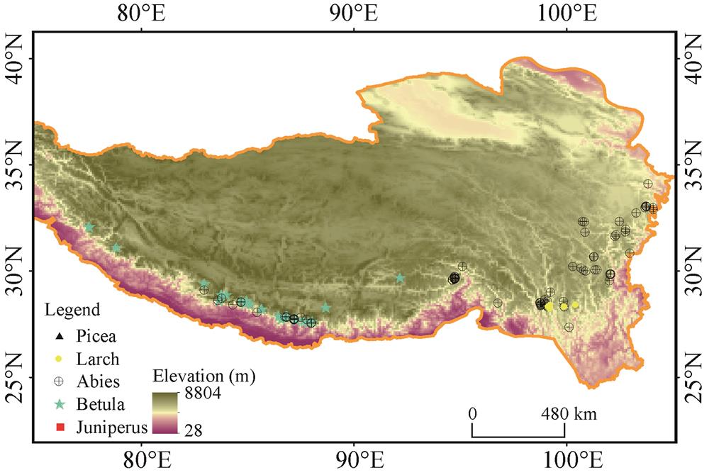
    Spruce-fir forests are distributed mainly in the southeastern part of the Tibetan Plateau, extending between 85-105°E and 26-38°N. In the southeastern part of the Tibetan Plateau and southern slope of the Himalayan Range, the coniferous species are diverse. It is reported that there are 16 species of Abies, 16 species of Picea, six species of Larix and 11 species of Juniperus (Sabina) on the Plateau. But only 14 species of genus Abies, five of Picea, five of Juniperus and four of Larix can reach climatic forest limit and consist of timberline species. In addition, schlerphyllous Quercus and deciduous broad-leaved trees, e.g. Betula, etc. can also form forest limit vegetation in west Himalaya, southeast Tibet and north Hengduan Mountaints. For example, Betula utilis presents at treeline in Uttarakhand, India. The Hengduan Mts. serve as species differentiation center of Abies. There are nine species of Abies in this region, of which Abies ferreana, A. squamata, A. nukiangensis, A. delavayi, A. georgei, A. georgei var. smithii, and A. forrestii constitue forest limit species. Kangding, in western Sichuan Province, is the species differentiation center of genus Picea and there covers over 10 species of spruce forests of the Qinghai-Tibet Plateau. But only some species such as Picea balfouriana, P. purpurea, P. likiangensis and P. crassifolia can reach forest limit and form timberline, in which P. balfouriana is the most common and widely distributed timberline species in eastern Tibet and northwestern Sichuan plateau. Larix is the forest limit genus on sunny slopes. In western Sichuan, L. potaninii is the widespread timberline species and can extend to Bailongjiang watershed of southern Gansu Province. L. potanini var. marcrocarpa is widely distributed in southwestern Sichuan, northwestern Yunnan and northeastern Tibet. At the elevation of 3800-4300 m, forest limit forms together with Aibes. Sabina (now Juniperus) is the alpine tree species and is the highest forest type to constitute forest limit. S. convallium, S. sultuaria and S. tibetica are the timberline species on sunny slopes in western Sichuan and eastern Tibet. In eastern Qinghai, southern Gansu and northwestern Sichuan, S. przewalskii, and S. komarovii are dominant timberline species on sunny slopes (Fig. 1).

    Fig. 1

    Figure 1.Fig. 1

    On southern slopes of the Himalayas, Juniperus indica, J. recurra and Abies spectabilis, A. densa, A. pindrow as well as Betula utilis occur at treelines (Schweinfurth, 1957; Stainton, 1972; Rawal and Pangtey, 1994). Quercus aquifolioides and Q. semecarpifolia can reach treeline on the sunny slopes of western Himalayas, western Sichuan and northwestern Yunnan provinces. In northwestern Yunnan, Abies geogei, Abies delavayi, Picea likiangensis, and P. likiangensis var. balfouriana constitute the timberline species. Elevation of timberline ranges from 3600 m in the southeastern section of the Himalayas to 4200 m in the eastern Tibet. The altitudes of timberline in Nepal and Indian Himalayan range from 3800 m to 4000 m (Fig. 2).

    Fig. 2

    Figure 2.Fig. 2

    2.2 Distribution patterns of timberline altitude on the Qinghai-Tibet Plateau

    (1) The elevation of timberline distribution on the Qinghai-Tibet Plateau

    In the southeastern part of the Qinghai-Tibet Plateau, the elevation of mountains decreases gradually with the advance of longitude. In general, the elevation of timberline increases from 3600 m in the western bordering mountains of Sichuan Basin to 4300 m in eastern Tibet and northwestern Sichuan plateau. In east Tibet and north section of the Hengduan Mts., Picea balfouriana and Abies squamata constitute the highest timberlines of spruce-fir forests in the world. The timberlines can reach 4300 m and even higher in the areas. Towards southeast, in the Sichuan Basin bordering mountains from Tianquan, Baoxing to Jiuzhaigou, Abies faxoniana, A. faberi and Picea purpurea grow on 3500- 3800 m to form timberline. 30°N is the natural boundary of spruce-fir species differentiation and their distribution. It is apparent that the elevation of timberline gradually increases with the decrease of latitude on the Qinghai-Tibet Plateau. The elevations of timberlines reach the highest position in 30°N. Northward from this latitude, the elevation of timberline begins to decrease (Li and Chou, 1984). North to latitude 30°N, Abies squamata, and Picea balfouriana are distributed to Makehe and Duokehe watersheds, south tip of Qinghai Province. The elevation of timberline is 4300 m in northwestern Sichuan Province and decrease to less than 4000 m in the wide valleys of south Qinghai Province. North to 35°N, these species are replaced by Picea crassifolia, P. purpurea, Sabina tibetica and S. przewalskii with timberlines lower than 3500 m. South to 30°N, i.e. south to the line of Batang-Litang-Yajang-Kangding, Abies gerogei, A. gerogei var. smithii and Picea likiangensis are distributed toward northwestern Yunnan Province and their timberlines decrease from 4200 m to 3800 m and even lower. The distribution of timberline is also closely correlative to longitude due to “Massenerhebung effect” (Schweinfurth, 1957). Spruce-fir forests extend from 85°E to 105°E on the Qinghai-Tibet Plateau. From 85°E to 96°E of east longitude, the timberlines of A. densa, A. spectabilis, A. delavayi, A.delavayi var. motuoensis, and A. chayuensis in South Himalayas are about 4000 m. To the eastern part of Tibet and north section of the Hengduan Mts., the elevations of timberline of Picea balfouriana, Abies squamata, and A. georgei var. smithii can reach maximal height at 4300 m. Toward east from 95°E to 105°E, the elevations of timberlines decrease gradually with the advance of longitude. Timberline species such as Pieca balfouriana and A. squamata are replaced by A. faxoniana, P. purpurea, A. forrestii, etc. from west to east. Tree species of timberlines are substituted by P. purpurea, A. faxoniana, A. fabric and A. forrestii from north to south. The elevation of timberline decrease gradually to about 3600 m and timberline decrease to 3400 m in eastern section of the Qilian Mountains.

    (2) The patterns of timberline distribution

    The elevations of timberline distribution along latitude and longitude are influenced markedly by the uplifting of the Qinghai-Tibet Plateau and vary complicatedly and irregularly on the Plateau. Some scientists named it as “plateau vegetation zonation” (Zheng et al., 1979; Chang, 1981).

    The latitude of timberline increases with the uplifting of the Plateau from east to west. The altitude of timberline distribution along longitude is approximate to parabola from 86-104°E. The peak area of timberline distribution is in the scope of 92-97°E. It is situated in the areas around the turn of the Yarlung Zangbo River and its tributary Polong Zangbo River, in eastern Tibet. From southeastern Tibet to the west, i.e., the southern slope of the Himalayas, the altitudes of timberlines are basically stable at the latitude of 4000-4100 m. From eastern Tibet to western Sichuan plateau, the elevations of timberlines decrease gradually and decline approximately in a form of straight line to the western bordering mountains of the Sichuan Basin.

    The elevations of timberline distribution across latitude ranging from 26°E to 38°E on the Qinghai-Tibet Plateau can be simulated by polynomial regression model. The peak areas of timberline distribution are around the latitude of 30°E.

    Three dimensional distribution of timberline along longitude and latitude can be modeled by surface analysis. It is indicated that the distribution of timberline elevation on the Plateau is in inverse “S” shape along latitude and longitude. The surface model of timberline distribution is:

    H = exp (-7.462 + 0.275x + 0.1995y - 0.0015x2 - 0.0032y2) (n = 149, R = 0.965)

    where H is the elevation of timberline, x is longitude and y is latitude. The timberline distribution reaches the highest elevation at 92.48°E and 31.32°N. It is right in the eastern part of Tibet that the Grand Canyon of the Yarlung Zangbo River is located.

    3 Climatic factors influence timberline distribution

    Temperature is a well-recognized predictor of timberline position and distribution in global scale. However, there are few weather stations established near timberline. A lot of temperature extrapolation from lower or nearby weather station was used as a proxy of climatic conditions at timberlines despite its bias. Therefore, there exist uncertainties because of topographical and vegetation status over there. The most acknowledged is that 10℃ warmest month isotherm was observed to represent the geographical location of the world timberline. Wang et al. (2004) extrapolated thermal condition to timberline in China. He found eastern Himalaya timberline is limited by growing season air temperature of 8.2℃ and annual bio-temperature (ABT) of 3.5℃ (Wang et al., 2004). This is similar to the extrapolation in Qinghai-Tibetan Plateau by Shi (1999) .

    Schickhoff (2005) extrapolated the temperature in timberline in Himalayan region and revealed remarkable differences in mean temperatures. Due to the higher degree of mass elevation effect, the mean temperature of the warmest month, which often range around 10℃ in northern hemisphere continental mountains, is distinctly higher in the northwest Himalaya and Karakorum (roughly between 10 and 13℃) compared to the more humid and monsoon- influenced eastern regions (Schickhoff, 2005). The effect of extensive mountain massifs as elevated heating surfaces leading to positive thermal anomalies compared with marginal ranges or free air. However the timberline in Tibet and east Himalaya develops at lower altitudes because of lower mean temperature induced by decline topography and cooling effect of humid monsoon climate.

    The air temperature of timberline shows great variation in different region. Holtmeier and Broll (2007) argued that mean temperatures differ too much so that air temperature is not suitable to be considered appropriate indicators of thermal conditions. Therefore, any isotherms of air temperature should not be considered the causal factor for upper timberline.

    Currently on-site observed ca. 6.5℃ of mean growing seasonal temperatures at depth of 10 cm soil, varies with very little site to site variation. The seasonal mean temperature has been proved as a better predictor of treeline position than warmest month temperatures or a suite of thermal sums tested (Körner and Paulsen, 2004). Over 10 automatic sensor TIDBIT monitoring sites of soil temperature at 10 cm depth at treelines averaged 7.1℃ of growing season soil temperature in eastern Himalaya, consistent with former observation (Körner et al., 2004; Shi et al., 2008). Growing season soil temperature is proved to be a thermal parameter more stable than air temperature, accumulated temperature, and length of growing season. It is common thermal threshold for forest growth at high elevation at global scale. The average 7.1℃ of seasonal treeline temperature is a little higher than the world average. It is might be due to elevation mass effect which increases the elevation of timberline and its thermal condition.

    Although soil temperature plays a profound role in seedling establishment, tree growth and survival, very few measurements of soil temperatures exist at treelines in the HKH mountains. More studies are necessary to be conducted in between treeline tree growth and soil temperature.

    4 Water, nutrient and carbon supply in treeline ecotone

    Körner (2012a) argues that there are no reasons to assume that water is limiting at the treeline because water supply is extremely variable there across the globe. Nonetheless, treelines usually climb up to higher elevation in drier environment. For example, Polylepsis reached to 5200 m a.s.l. in Bolivia. Junipers arrive 4800 m in South Tibet (Hoch and Körner, 2005; Miehe et al., 2007). Consequently, it seems that water is not the limiting factor control the elevation of treelines. However, from point view of physical geography, water relation is the locally important mediator of treeline elevation (Liang et al., 2014). In any case low temperature is undoubtedly the prominent controller of timberline.

    It is assumed that nutrient becomes limitation in high altitudinal treeline because nutrient availability is constrained by low temperature. But there are two facts against this assumption. First, the nutrient contents, especially nitrogen, in organisms at treelines are never less than those in closed forest in lower altitude (Birmann and Korner, 2009). Second, treeline patterns do not show higher elevation in nutrient-accumulative areas and climb up higher elevation in area of rich nutrient (Körner, 2012c). Fertilization manipulation did not facilitate treeline uplift. Thus, growth is more temperature-limited than nutrient acquisition is (Tranquillini, 1979). After all, low temperature is the most key limiting factors for treeline formation.

    The debate over the mechanistic factors that limit the altitudinal treeline has been continued for over a century (Tranquillini, 1979; Körner, 2012a; Körner, 2018). Environmental effects on both photosynthetic carbon gain and respiration-driven growth processes have been acknowleged to evaluate limitations at the alpine treeline (Körner, 2003). Most of these earlier studies have focused on correlations between treeline altitudes worldwide and associated mean minimum annual temperatures. According to these more traditional ideas, trees are unable to assimilate enough carbon for survival above certain altitudes (Stevens and Fox, 1991; Tranquillini, 1993). However, Körner proposed that low soil temperatures coupled with physiological drought stress inhibit the carbon processing abilities at treeline, not their capabilities for carbon gain via photosynthesis (Körner, 1998a; Körner, 2003). Körner’s hypothesis about the altitudinal extent of treelines suggests that it is not limitation to photosynthetic carbon gain at high elevation, but the processing of fixed carbon into growth via respiratory physiology. A more recent study suggests that increasing non-structural carbon pools without significant growth is caused by carbon source availability exceeding demand (Körner, 2003). Shi et al. (2008) indicated that the highest treeline in the eastern Himalayas all show no less, non-structural carbohydrate (NSC), with even significant higher NSC, at treelines compared with its lower closed forests. Another evidence of no NSC limitation at treeline showed linear increase of NSC in woody plants with increase of altitude in Wolong Nature Reserve of giant panda (Shi et al., 2006). Although there is carbon limitation phenomena in Gongga Mountains in eastern Tibetan Plateau, this temporary depletion of carbon occurred in sprout burst in early spring (Li et al., 2008). Although lots of evidence supporting the treeline hypothesis of growth limitation rather than carbon source limitation (Millard et al., 2007), in rebate with the former hypothesis, NSC is considered to be also active storage despite short of carbon during stress. This may also cause increase of NSC while carbon limitation (Wiley and Helliker, 2012; Wiley et al., 2013). Trees may actively maintain or increase NSC levels under carbon stress, with apparently increased NSCs while reduced growth (Wiley et al., 2013).

    5 Impact of global warming on treeline change

    The Himalayas experienced increasing warming in the past two decades. Himalayas have warmed by 1.5℃ from 1982 to 2006, at an average rate of 0.06 ℃ yr-1. Temporal differentiation present seasonal difference with greatest average increase of 0.07 ℃ yr-1 in winter, and least increase, 0.03 ℃ yr-1 in summer (Shrestha et al., 2012). Treelines are sensitive to respond to climate warming by advancing beyond their current position or enhancing growth. It is usually assumed that treeline ecotone will undergo significant change in terms of structure and position shift. As a result, treeline is expected to shift in response to global warming. So far there is abundant evidence of tree growth enhancement or treeline shift in Himalayas in the past decades.

    Monitoring treeline shift response to climate change is possible with the use of “an eye in the sky” (i.e. remote sensing satellite) in the inaccessible Himalayan terrain (Rawat, 2012). Panigrahy et al. (2010) mapped treeline by using nearly 20-year satellite images. In the glacier areas in 1986, the 2004 imagery revealed dramatic increase of vegetation cover and drastic reduction of snow cover in Nanda Devi Biosphere Reserve, central Indian Himalaya. Alpine plant species have been found to shift to higher elevations, though the shifting rate varies with species and their sensitivity to climate. This study indicated that the ecosystems in the Himalaya have experienced significant changes since1960 (Panigrahy et al., 2010). However, Negi (2012) thought that treeline dynamics is more related to the deflected snow precipitation system rather than global warming in the Himalaya (Negi, 2012). Also by remote sensing, Singh et al. (2012) assessed that the treeline had shifted 388 ± 80 m upwards in Uttarakhand Himalaya during 1970- 2006. Despite its roughness, prevalent treeline advancing shift and vegetation cover change have been monitored through remote sensing. In northwest Yunnan Province, East Himalaya, glacier recession and advancing treeline was also indicated by repeated photos and supplement measurements (Baker and Moseley, 2007).

    However, in-site observation is few due to remoteness and costing. In east Himalayas, treeline shift is not apparent. Most of treeline vegetation change is growth and regeneration enhancement rather than treeline shift. In eastern Tibet, an abrupt recruitment in the 1970s but no significant upward movement of treeline position was found in eastern Tibet smith fir treeline (Liang et al., 2011). The recruitment of juveniles and seedlings were established preferentially near juvenile fir, Rhododendron mats and over moss-lichen and organic matter substrates, indicating the importance of microsites availability for successful Smith fir recruitment (Wang et al., 2012).

    With increasing warming, the length of growing season is significantly extended. However, little effect of increasing growing season on tree ring growth. For example, in Sygera Mts eastern Tibet, a weather station record at timberline (4390 m) and modeled length of growing season has significantly extended by 21.2 days, with a significant delay of its end (by 14.6 days) rather than from an earlier onset (by 6.6 days). Nevertheless, lengthening of the growing season did not yet enhance radial growth of Smith firs at the timberline (Liu et al., 2013).

    However, shrub species competition in the treeline ecotone may become a barricade to slow down upward movement of treeline (Liang et al., 2016). Recently warming induced pre-monsoon drought played negative effects on tree growth at treelines in semiarid areas, for example in western Nepal and Indian Himalaya (Rahman et al., 2018; Sigdel et al., 2018a; Sigdel et al., 2018b) and northeastern Tibetan Plateau (Liang et al., 2016; Mou et al., 2019).

    In summary, the timberlines of Himalayan region are among the highest over the world due to great mass elevation effect of the Tibetan Plateau. Simultaneously this area also represents the most diverse timberline species and thus geomorphology and tree species diversity determine the abundant timberline growth forms and timberline forms. In contrast to air temperature isotherms of timberline, growing season mean soil temperature at the soil depth of 10 cm represents consent thermal conditions of nearly 7℃ over the world. It is indicated low temperature is the most dominant controlling factors of timberline. Trees at timberline ecotone are not in a physiological inferiority compared to other life forms. It appears that low temperature limits carbon sink rather than carbon source in timberline. So timberline is a threshold of growth limitation caused by low temperature. There is no reason to assume that water and nutrient are the key factors to determine timberline position, specifically they are at the most the modulating factors in local environment. In the future global warming scenario, timberline will be expected to advance to higher altitude, but in most cases, increasing tree recruitment and tree growth is the case rather timberline advancing.

    References

    [1] B Baker B, K Moseley R. Advancing treeline and retreating glaciers: Implications for conservation in Yunnan, P. R. China. Arctic, Antarctic, and Alpine Research, 39, 200-209(2007).

    [2] K Birmann, C Korner. Nitrogen status of conifer needles at the alpine treeline. Plant Ecology & Diversity, 2, 233-241(2009).

    [3] S Chang D H. The vegetation zonation of the Tibetan Plateau. Mountain Research and Development, 1, 29-48(1981).

    [4] G Hoch, C Körner. Growth, demography and carbon relations of Polylepis trees at the world’s highest treeline. Functional Ecology, 19, 941-951(2005).

    [5] K Holtmeier F, G Broll. Treeline advance — Driving processes and adverse factors. Landscape Online, 1, 1-32(2007).

    [6] C Körner. A re-assessment of high elevation treeline positions and their explanation. Oecologia, 115, 445-459(1998).

    [7] C Körner. Worldwide positions of alpine treelines and their causes. In: Beniston M, Inne J L (eds.). The impacts of climate variability on forests, lecture notes in earth sciences(1998).

    [8] C Körner. Alpine plant life: Functional plant ecology of high mountain ecosystems (2nd edition). Berlin: Springer.(2003).

    [9] C Körner. Climatic treelines: Conventions, global patterns, causes. Erdkunde, 61, 316-324(2007).

    [10] C Körner. Alpine treelines — Functional ecology of the global high elevation tree limits. Basel: Springer.(2012).

    [11] C Körner. Treelines will be understood once the functional difference between a tree and a shrub is. AMBIO, 41, 197-206(2012).

    [12] C Körner. Water, nutrient and carbon relations. In: Körner C (ed.). Alpine Treelines. Basel: Springer, 151-168(2012).

    [13] C Körner. Alpine ecosystems and the high-elevation treeline. In: Sven Erik J, Brian D F (eds.). Encyclopedia of ecology, 407-413(2018).

    [14] C Körner, J Paulsen. A world-wide study of high altitude treeline temperatures. Journal of Biogeography, 31, 713-732(2004).

    [15] C Kuan. The geography of conifers in Sichuan(1982).

    [16] M Li, W Xiao, P Shi et al. Nitrogen and carbon source-sink relationships in trees at the Himalayan treelines compared with lower elevations. Plant, Cell & Environment, 31, 1377-1387(2008).

    [17] W Li, P Chou. The geographical distribution of the spruce-fir forest in China and its modelling. Mountain Research and Development, 4, 203-212(1984).

    [18] W Li, Y Han, M Shen. Tibetan forests.(1985).

    [19] E Liang, B Dawadi, N Pederson et al. Is the growth of birch at the upper timberline in the Himalayas limited by moisture or by temperature?. Ecology, 95, 2453-2465(2014).

    [20] E Liang, C Leuschner, C Dulamsuren et al. Global warming-related tree growth decline and mortality on the North-Eastern Tibetan Plateau. Climatic Change, 134, 163-176(2016).

    [21] E Liang, Y Wang, D Eckstein et al. Little change in the fir tree-line position on the southeastern Tibetan Plateau after 200 years of warming. New Phytologist, 190, 760-769(2011).

    [22] E Liang, Y Wang, S Piao et al. Species interactions slow warming-induced upward shifts of treelines on the Tibetan Plateau. Proceedings of the National Academy of Sciences of the USA, 113, 4380-4385(2016).

    [23] B Liu, Y Li, D Eckstein et al. Has an extending growing season any effect on the radial growth of Smith fir at the timberline on the southeastern Tibetan Plateau?. Trees, 27, 441-446(2013).

    [24] Z Liu. The vegetation of Gongga Mountain.(1985).

    [25] G Liu Z, C Zhong Z. Sichuan vegetation(1980).

    [26] G Liu Z, C Zhong Z. Sichuan vegetation(1980).

    [27] G Miehe, S Miehe, J Vogel et al. Highest treeline in the northern hemisphere found in southern Tibet. Mountain Research and Development, 27, 169-173(2007).

    [28] P Millard, M Sommerkorn, A Grelet G. Environmental change and carbon limitation in trees: A biochemical, ecophysiological and ecosystem appraisal. New Phytologist, 175, 11-28(2007).

    [29] M Mou Y, O Fang, X Cheng et al. Recent tree growth decline unprecedented over the last four centuries in a Tibetan juniper forest. Journal of Forestry Research, 30, 1429-1436(2019).

    [30] S Negi P. Climate change, alpine treeline dynamics and associated terminology: Focus on northwestern Indian Himalaya. Tropical Ecology, 53, 371-374(2012).

    [31] S Panigrahy, D Anitha, M Kimothi M et al. Timberline change detection using topographic map and satellite imagery. Tropical Ecology, 51, 87-91(2010).

    [32] M Rahman, M Islam, A Bräuning. Tree radial growth is projected to decline in South Asian moist forest trees under climate change. Global and Planetary Change, 170, 106-119(2018).

    [33] S Rawal R, S Pangtey Y P. Distribution and structural-functional attributes of trees in the high altitude zone of Central Himalaya, India. Vegetatio, 112, 29-34(1994).

    [34] S Rawat D. Monitoring ecosystem boundaries in the Himalaya through an “eye in the sky”. Current Science, 102, 1352-1354(2012).

    [35] U Schickhoff. The upper timberline in the Himalayas, Hindu Kush and Karakorum. In: Broll G, Keplin B (eds.). A review of geographical and ecological aspects. mountain ecosystems. studies in treeline ecology, 275-354(2005).

    [36] U Schweinfurth. The horizontal and vertical spread of vegetation in Himalayas. Bonn Geographical Treatises, 20, 373-379(1957).

    [37] P Shi. A study on the vegetation ecology of subalpine timberline ecotone. PhD diss., Beijing: Chinese Academy of Sciences(1999).

    [38] P Shi, C Körne, G Hoch. End of season carbon supply status of woody species near the treeline in western China. Basic and Applied Ecology, 7, 370-377(2006).

    [39] P Shi, C Körner, G Hoch. A test of the growth-limitation theory for alpine tree line formation in evergreen and deciduous taxa of the eastern Himalayas. Functional Ecology, 22, 213-220(2008).

    [40] B Shrestha U, S Gautam, S Bawa K. Widespread climate change in the Himalayas and associated changes in local ecosystems. Plos One, 7, e36741(2012). https://www.ncbi.nlm.nih.gov/pubmed/22615804

    [41] R Sigdel S, B Dawadi, J Camarero J et al. Moisture-limited tree growth for a subtropical Himalayan conifer forest in Western Nepal. Forests, 9(2018).

    [42] R Sigdel S, Y Wang, J Camarero J et al. Moisture-mediated responsiveness of treeline shifts to global warming in the Himalayas. Global Change Biology, 24, 5549-5559(2018).

    [43] P Singh C, S Panigrahy, A Thapliyal et al. Monitoring the alpine treeline shift in parts of the Indian Himalayas using remote sensing. Current Science, 102, 559-562(2012).

    [44] A Stainton J D. Forest of Nepal. London: John Murray.(1972).

    [45] C Stevens G, F Fox J. The causes of treeline. Annual Review of Ecosystem and Systematics, 22, 171-191(1991).

    [46] W Tranquillini. Physiology ecology of the alpine timberline — Tree existence at high altitudes with special reference to the European Alps. Berlin: Springer(1979).

    [47] W Tranquillini. Climate and physiology of trees in the alpine timberline regions. Palder Klimaforschung, 9, 127-136(1993).

    [48] X Wang, L Zhang, Y Fang J. Geographical differences in alpine timberline and its climate interpretation in China. Acta Geographica Sinica, 59, 871-879(2004).

    [49] Y Wang, J Julio Camarero, T Luo et al. Spatial patterns of Smith fir alpine treelines on the south-eastern Tibetan Plateau support that contingent local conditions drive recent treeline patterns. Plant Ecology & Diversity, 5, 311-321(2012).

    [50] P Wardle. Alpine timberline. In: Ives J D, Barry R G (eds.). Arctic and alpine environments, 371-402(1974).

    [51] E Wiley, B Helliker. A re-evaluation of carbon storage in trees lends greater support for carbon limitation to growth. New Phytologist, 195, 285-289(2012).

    [52] E Wiley, S Huepenbecker, B Casper B et al. The effects of defoliation on carbon allocation: Can carbon limitation reduce growth in favour of storage?. Tree Physiology, 33, 1216-1228(2013).

    [53] Y Wu C. Vegetation of China.(1980).

    [54] Y Yao, B Zhang. The mass elevation effect of the Tibetan Plateau and its implications for alpine treelines. International Journal of Climatology, 35, 1833-1846(2015).

    [55] W Zhang J, T Wang J, L Chen W et al. Tibetan vegetation.(1988).

    [56] D Zheng, Q Yang. Some problems on the altitudinal belts in southeastern Qinghai-Xizang (Tibetan) Plateau. Acta Geographica Sinica, 40, 60-69(1985).

    [57] D Zheng, R Zhang, Q Yang. Physic-geographic differentiation of the Qinghai-Tibetan Plateau. In: Zheng D (ed.). Geological and ecological studies of Qinghai-Xizang Plateau, 1851-1860(1981).

    [58] D Zheng, R Zhang, Y Yang Q. On physical zones in the Qinghai-Tibetan Plateau. Acta Geographica Sinica, 34, 1-11(1979).

    [59] Y Zheng. A study on the correlation between montane forest vegetation and climate in the southeastern part of Qinghai-Tibetan Plateau. PhD diss., Beijing: Institute of Geography, Chinese Academy of Sciences(1995).

    Peili SHI, Ning WU, S. RAWAT Gopal. The Distribution Patterns of Timberline and Its Response to Climate Change in the Himalayas[J]. Journal of Resources and Ecology, 2020, 11(4): 342
    Download Citation