
Yang GAO, Junjie JIA, Yao LU, Xiaomin SUN, Xuefa WEN, Nianpeng HE, Tiantian YANG. Progress in watershed geography in the Yangtze River Basin and the affiliated ecological security perspective in the past 20 years, China[J]. Journal of Geographical Sciences, 2020, 30(6): 867
- Journal of Geographical Sciences
- Vol. 30, Issue 6, 867 (2020)
Abstract
Keywords
1 Introduction
In geographical research, which accounts for either part or the entire earth surface as a basic unit (
The Yangtze River is the longest river in China and the third longest river in the world with a total length greater than 6300 km which includes 180×l04 km2 of watershed area that occupies approximately one-fifth of the total area of China. Furthermore, the population of the region accounts for about one third of the country, and the cultivated land area accounts for one quarter of the country. However, the total agricultural output value accounts for 40% of the country (
However, there is a lack of a unified understanding on the current status of resources in the YRB as well as river-lake water system connectivity and an assessment of its environmental effects. Moreover, this lack of knowledge also includes spatial and temporal differentiation rules associated with water and material cycling in the YRB and associative driving mechanisms, critical zone watershed processes, and the evolutionary mechanisms of service functions, especially in forecasting future developmental trends in the YRB under a background of global climate change. Accordingly, this study comprehensively analyzes research hotspots and key funding fields associated with geographical resources and ecological environments within the YRB in recent decades, while proposing future geographic research objectives and the strategic design of scientific research in the YRB to ensure continued ecological security of the important, sustainable socioeconomic development role it plays in China.
2 Progress of research on the YRB in the New Era
2.1 Research hotspots in the YRB supported by the NSFC over the past 20 years
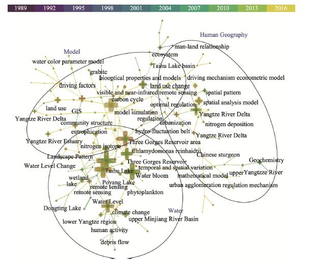
From March to April 2019, we collected 856 fund projects on the official website of the National Natural Science Foundation of China (NSFC) (http://www.nsfc.gov.cn/). The collection conditions were as follows: (1) these projects were concluded from 1988 to 2017; (2) application codes included: C03 (Ecology), D01 (Geography), D03 (geochemistry) and E09 (water science and Marine Engineering); (3) funding category included all fund types; (4) the research scope was the YRB. Over the past 20 years, high-frequency keywords associated with YRB studies have been the “Three Gorges Reservoir”, “Taihu Lake”, “water bloom”, “eutrophication”, “Three Gorges Reservoir area”, “Poyang Lake”, “model simulation”, “geographic information system”, “spatial analysis”, “urbanization”, “land use”, “Yangtze River Delta”, “land-use change”, “climate change” and “human activities” (
![]()
Figure 1.
Research on geoscientific hotspots in the YRB can be divided into three categories according to co-occurrence relationships: 1) Hotspots related to water bodies that primarily include the “Three Gorges Reservoir”, “Taihu Lake”, “water bloom”, “eutrophication”, and “Poyang Lake”; 2) hotspots associated with human geography containing the words “spatial pattern”, “driving mechanism”, “optimal regulation”, and “land-use change”; 3) model- based hotspots containing the words “model simulation”, “bio-optical properties and models”, “water color parameter model”, “spatial analysis model”, and “econometric model”. The Three Gorges Reservoir, Taihu Lake, Poyang Lake, Yangtze River Delta, Yangtze River Estuary, and Minjiang River have been the main areas of focus in the YRB. Moreover, lakes, wetlands, phytoplankton, algae, water quality, land use, human activities, and moss have been the key study objects in the YRB, while remote sensing, corresponding latitude, geographic information system, model, and measurement have been the main research methods used in the YRB.
The YRB played an important role in Geosciences, especially in the research of community structure and eutrophication. In the past 20 years, the number of NSFC funded geoscience research projects increased steadily. Among them, the proportion of projects in the YRB supported by NSFC increased in a fluctuating trend (1% to 6%), and the growth rate had accelerated since 2005, reaching a peak in 2014. The YRB had become a hot area in the field of Geosciences. Among the projects concluded in 2017, the number of projects supported by the NSFC for the YRB is 125, accounting for 6.4% of the total number of projects in the field of Geosciences. Over the past 20 years, with 2005 being the key demarcation point, the NSFC has increased its subsidies to the YRB (
![]()
Figure 2.
2.2 Research hotspots in the YRB supported by the MST over the past 20 years
For the YRB projects supported by the Ministry of Science and Technology (MST) of the People’s Republic of China, we further compared relationships between the YRB research and investments from national science and technology (
![]()
Figure 3.
2.3 Changes in research status and hot topics of the YRB
In accordance with research result cluster analyses in the YRB from the China National Knowledge Infrastructure (CNKI) over the past 20 years (
![]()
Figure 4.
Papers on the YRB published by Chinese scholars on the Web of Science in the past 20 years were used to conduct co-citation analysis. The results were clustered, showing cluster labels by log-likelihood, labeling clusters with indexing terms (
![]()
Figure 5.
3 Physiographical and national ecological security strategies of the YRB
Under a holistic and historical perspective, using basin as a unit, emphasizing the natural attributes of the basin, its human trajectory, historical evolution, and rules respective to its dynamic development are important in understanding the basic conditions of sustainable development in different watersheds and in providing a scientific basis for the regional research response to global change (
3.1 National appeal for research in the YRB in the New Era
To resolve ecological and environmental problems in the YRB on a national scale, it is paramount to strengthen multidisciplinary intersections and to view this as the core of geoscientific research as well as providing a strategic scientific design of a future watershed system approach. This will fundamentally improve our understanding of the YRB as well as scientifically-based research in the region, while it will also allow us to come to terms with the necessity of investigating the joint prevention and control aspect associated with ecological problems in the YRB. Key scientific issues and techniques that must be addressed include: 1) Those based on long-term observation system data under holistic, system-based, and multi-scale spatiotemporal perspectives, namely, the study of watershed behavior, regulatory aspects associated with evolution, and system interactions between water cycles and the ecological environment within critical zones of watersheds; 2) the means by which to scientifically evaluate cyclic material changes in interfaces and environmental effects as well as their impact on biodiversity under a scenario of dam fluctuation; 3) the regulation of eco-hydrological and geochemical processes as well as achieving and controlling purification measures associated with compound pollution in the watershed under a connective river-lake system strategy; 4) the integration of big data, extensive platforms, and system observations, while establishing an early-warning system along with the comprehensive management of the YRB.
Furthermore, regional observation platform networks that account for material and energy flux in ecosystems throughout the world have become the most valuable geoscientific tool as well as providing the most abundant data source on global climate change. The role of a network platform is unique in tackling global climate change, providing scientific and technological support for sustainable development, developing earth observation systems and scientifically-based global climate change research initiatives, while recognizing regional patterns and long-term changes in material and water cycle processes. Geoscience has entered the research era of big data and big science, which poses new challenges and opportunities in geoscientific development. Therefore, to satisfy China’s strategies on ecological environmental construction projects and regional sustainable development in the YRB, new technologies, methods, and perceptions are necessary from the perspective of disciplinary development in the prospective development of frontier research fields as well as new directions in geoscience that promote large-scale and comprehensive scientific research based on big science and big data, while also developing a quantitative, predictable, early-warning system under expedient conditions associated with spatial management and control.
3.2 Key issues under national appeal in watershed physiographical research
Respective of the aforementioned research hotspots on watershed physiography, current trends in development, and major research goals in geography, this study proposes a series of key geographical research topics for the YRB: 1) Determining both developmental and historical evolutionary processes in the YRB, investigating erosion and environmental evolutionary processes in the YRB (
3.3 Earth system science and the implementation of ecological security research in the YRB
There is a great need for the application and utilization of a national field monitoring platform, the synthetization of multidisciplinary intersections, the exploration of new technologies, new methods, and new concepts within a prospective design of frontier research fields as well as determining the direction to take in ecological security and governance in the YRB. Furthermore, it is also necessary to understand holistic behavior, regulatory evolutionary processes, and interactions between watershed intersystems using an ecologically-based big data platform while scrutinizing the design of the platform with respect to the YRB. Also, there is a pressing need to establish an early-warning system and the spatial management and control of resource allowances in the YRB. Lastly, we determined that four aspects related to earth system science must be strengthened in the YRB, namely, integrating C-N-H2O coupling and energy cycles (see
![]()
Figure 6.
(1) Long-term observation data, integrating data from literature on the YRB, strengthening the comprehensive study of C-N-H2O coupling and energy cycles
The integration and analysis of long-term observation system data on the YRB, as well as understanding scientific problems associated with long-term changes and regional pattern research on coupling cycles of carbon, nitrogen, water, and energy in the YRB should be proposed (
(2) Proposing key technologies and frontier designs in resolving urgent issues in the study of processes associated with land-river habitats
The most crucial issues that must be resolved using digital hydrological tools and water quality monitoring platforms in the YRB, while promoting the national development of and the strategic appeal for research. We should also propose incorporating critical technologies that are necessary to resolve water cycling issues in the YRB under a changing environment, improve the ability to reconstruct and analyze processes associated with historical changes in river water quality and water quantity versus nutrient flux in the YRB, and determine the role of natural factors and human activities in river water quality and water quantity versus nutrient transport, while conducting coupling studies on water quality and water quantity versus nutrients at different scales (
(3) Comprehensive investigation of biological and pollution processes in critical zones of the YRB under connective river-lake systems
This study focused on issues related to migration and transformation processes associated with biological elements and pollutants in the critical zones of the YRB under a scenario of dam fluctuation and also scientifically evaluated the absorption and purification of pollutants and their impact on biodiversity under a scenario of dam fluctuation. This study also focused on determining the ecological red line of ecological water security in the YRB, while formulating conservation zoning of biodiversity in the YRB using the Yangtze River Bioinformatics Data Platform Strategy.
(4) Comprehensive study on the resource status, scheduling, and ecological security in the YRB
By determining each element in detail as well as regional network observations and experiments in combination with the application of new technologies, such as ground-satellite stereoscopic observations, laser and radar detection technologies, unmanned aerial vehicles, and information and automation technologies, the aim of this study was to strengthen comprehensive observations and experimental research of a three-dimensional surface-air network, to determine current conditions in the YRB, to comprehensively evaluate ecosystem functions, resource carrying capacities, and the sustainable management and utilization strategies in the YRB, while also proposing watershed resource scheduling strategies suitable for multi-space and multi-time scales. The aim was also to establish real-time predictions, warning systems and assessments, while optimizing ecological security management and measures by which to serve the national eco-environmental strategy of the YRB.
4 The inspiration of CERN to geographical research in the YRB
The objective of CERN is to implement a national strategy and provide important measures required by the Central Committee of the Communist Party of China, providing a prospective design for comprehensive multi-factor and multi-scale observations of processes in terrestrial ecosystems in China as well as a stereo-observation system combined with near- surface and remote sensing imagery. The great advantages of CERN to scientific research in earth system sciences primarily include the following three factors (
The impact of global climate change is becoming increasingly severe. The development of earth system science and solutions to problems associated with ecological environmental degradation will undoubtedly depend on scientific and technological progress in the field of earth system science. Accordingly, new technological applications and long-term comprehensive observations and experiments associated with a three-dimensional ground-air network have become the mainstream in the promotion of geoscientific and technological innovations and progress. The establishment of CERN is indispensable in resolving scientific problems associated with network monitoring data, simulation experiments, and numerical laboratory simulations for long-term earth system science research. Furthermore, based on regional network observations and experiments, ground-satellite stereoscopic observations, newly-developed technological applications (such as laser and radar detection technology as well as information and automation technology), which can detect individual elements of ecosystems in minute detail, have become the main developmental trends in scientific and technological innovations and progress in earth system science research. To resolve ecological issues on a national scale, the promotion of scientific and technological advancements and comprehensive capabilities in field observations and experimental research as well as the integration and the sharing of field observations and experimental technological resources are urgently required (
5 Summary
(1) The unique geographical location and the natural environment of the YRB, the contradictory nature associated with its long history of human activities, and the current relationship between humans and the land, which increases national competitiveness during economic transition periods, have all provided a broad platform and a significant regional superiority to conduct geographical research on a regional scale in the YRB.
(2) Long-term observations, experiments, and simulations are an impetus to today’s mainstream scientific and technological innovations and progress in earth system science, while geography and fields that study global climate change have largely curtailed potential discoveries, rules of interpretation, and mechanistic clarity in the past, which now attaches great importance to ecosystem function maintenance and sustainable management.
(3) Frontier scientific issues of concern include: basic relationships between changes in ecosystem material cycles, service functions, environmental resources, human well-being, impacts and feedbacks of global climate change on ecosystem material cycling, and relationships between ecosystem degradation or restoration and regional sustainable development and ecological security.
(4) The response and adaptation of environmental carbon-nitrogen water cycles to global climate change is considered a frontier field in geoscientific and ecological research. The National Academy of Sciences and the Ecological Society of America have clearly stated that carbon-nitrogen-water cycles and their associative coupling processes that both respond and react to climate change provide new opportunities in future geoscientific development.
References
[1] D D Baldocchi. Assessing the eddy covariance technique for evaluating carbon dioxide exchange rates of ecosystems: Past, present and future. Global Change Biology, 9, 479-492(2003).
[2] H S Cai, X L Zhang, H S Huang et al. The theories and methods of lake-watershed land ecological management. Journal of Natural Resources, 25, 1049-1058(2010).
[5] Virgilio N Di, O Facini, A Nocentini et al. Four‐year measurement of net ecosystem gas exchange of switchgrass in a Mediterranean climate after long‐term arable land use. Global Change Biology Bioenergy, 11, 466-482(2018).
[6] B J Fu. The integrated studies of geography: Coupling of patterns and processes. Scientia Geograpica Sinica, 69, 1052-1059(2014).
[11] Y Gao, Z Hao, N Han et al. Tracking the fate of deposited nitrogen and its redistribution in a subtropical watershed in China. Ecohydrology, 12, e2094(2019).
[12] Y Gao, Y L Jia, G R Yu et al. Anthropogenic reactive nitrogen deposition and associated nutrient limitation effect on gross primary productivity in inland water of China. Journal of Cleaner Production, 208, 530-540(2019).
[13] Y Gao, G R Yu, T T Yang et al. New insight into global blue carbon estimation under human activity in land-sea interaction area: A case study of China. Earth-Science Reviews, 159, 36-46(2016).
[14] Y Gao, F Zhou, P Ciais et al. Human activities aggravate nitrogen deposition pollution to inland water over China. National Science Review, 7, 430-440(2020).
[17] Z Hao, Y Gao, T Yang. Seasonal variation of DOM and associated stoichiometry for freshwater ecosystem in the subtropical watershed: Indicating the optimal C:N:P ratio. Ecological Indicators, 78, 37-47(2017).
[18] R Z Hou. Four Theories about the History of Geography(1994).
[19] X M Lai, Q Zhu, Z W Zhou et al. Optimizing the spatial pattern of land use types in a mountainous area to minimize non-point nitrogen losses. Geoderma, 360, 114016(2020).
[20] R Liu, E Cieraad, Y Li et al. Precipitation pattern determines the inter-annual variation of herbaceous layer and carbon fluxes in a phreatophyte-dominated desert ecosystem. Ecosystems, 19, 601-614(2016).
[21] D D Lu. Conservation of the Yangtza River and sustainable development of the Yangtze River Economic Belt. Acta Geographica Sinica, 73, 1829-1836(2018).
[23] D X Kong, C Y Miao, A G L Borthwick et al. Evolution of the Yellow River Delta and its relationship with runoff and sediment load from 1983 to 2011. Journal of Hydrology, 520, 157-167(2015).
[24] L Q Kong, Y Q Wang, H Zheng et al. A method for evaluating ecological space and ecological conservation redlines in river basins: A case of the Yangtze River Basin. Acta Ecologica Sinica, 39, 835-843(2019).
[25] C Y Miao, D X Kong, J W Wu et al. Functional degradation of the water-sediment regulation scheme in the lower Yellow River: Spatial and temporal analyses. Science of the Total Environment, 551/552, 16-22(2016).
[27] D Struck. Setting rivers free: As dams are torn down, nature is quickly recovering. Christian Science Monitor(2016).
[28] J Xia, Y Gao, Q T Zuo et al. Characteristics of interconnected rivers system and its ecological effects on water environment. Progress in Geography, 31, 26-31(2012).
[29] P Xie, M Dou, Y Zhu et al. Watershed Hydrological Model-hydrological and Water Resources Effects to Climate Change and Land Use/Cover Change(2010).
[30] Y L Xie. The historical changes of Yangtze River traffic and economic landscape. Chinese Historical Geography, 27-44(1995).
[31] S Y Wang, H Z Zhang. An idea to learn about creating a historical watershed. Guangming Daily(2009).
[32] X H Wei, G Sun. The Watershed Ecosystem Processes and Management Systems(2009).
[33] G R Yu, Y L Fu, X M Sun et al. Recent progress and future directions of China FLUX. Science in China Series D, 36, 1-21(2006).
[34] G R Yu, Y Gao, Q F Wang et al. Discussion on the key processes of carbon-nitrogen-water coupling cycles and biological regulation mechanisms in terrestrial ecosystem. Chinese Journal of Eco-Agriculture, 21, 1-13(2013).
[35] G R Yu, N P He, Q F Wang. Carbon Budget and Carbon Sink of Ecosystems in China(2013).
[37] G R Yu, X F Wen, X M Sun et al. Overview of China FLUX and evaluation of its eddy covariance measurement. Agricultural and Forest Meteorology, 137, 125-137(2006).
[38] G R Yu, L M Zhang, X M Sun et al. Progresses and prospects of Chinese terrestrial ecosystem flux observation and research network (ChinaFLUX). Progress in Geography, 33, 903-917(2014).
[39] G H Yang, D X Wang, Y Z Feng. Eco-environmental Change and Quality Assessment in Source Regions of Rivers(2008).
[40] J Zhang, T S Li, D H Zhou et al. Research progress on man-earth areal system in river basin. Arid Land Geography, 34, 364-376(2011).
[41] H Zheng. Birth of the Yangtze River: Age and tectonic-geomorphic implications. National Science Review, 2, 438-453(2015).
[42] W Zheng, X Z Yuan, H Liu et al. Influence of regional climate change on vegetation cover in the middle and lower Yangtze River Basin. Research of Environmental Sciences, 27, 1032-1042(2014).
[44] Q Zhu, M J Castellano, G S Yang. Coupling soil water processes and the nitrogen cycle across spatial scales: Potentials, bottlenecks and solutions. Earth-Science Reviews, 187, 248-258(2018).


Set citation alerts for the article
Please enter your email address

© Copyright 2018-2021 | Chinese Laser Press. All Rights Reserved 沪ICP备15018463号-20