
Hesong DONG, Renjie LI, Jianming LI, Shuai LI. Study on Urban Spatiotemporal Expansion Pattern of Three First-class Urban Agglomerations in China Derived from Integrated DMSP-OLS and NPP-VIIRS Nighttime Light Data [J]. Journal of Geo-information Science, 2020, 22(5): 1161
- Journal of Geo-information Science
- Vol. 22, Issue 5, 1161 (2020)
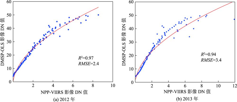
Fig. 1. The power function relation between DMSP-OLS and average DN values in corresponding region of NPP-VIIRS for 2012, 2013
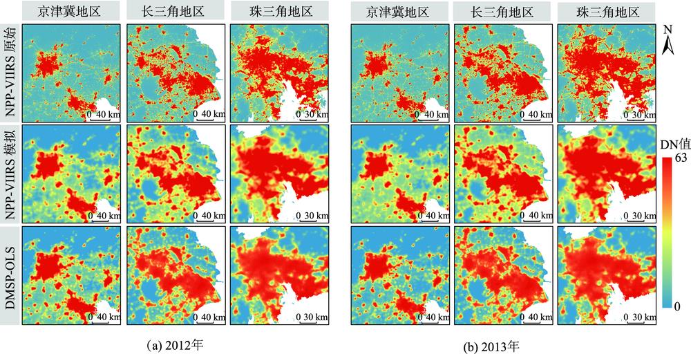
Fig. 2. Spatial pattern of DMSP-OLS and NPP-VIIRS simulated data for part of the Beijing-Tianjin-Hebei, part of the Yangtze River Delta, part of the Pearl River Delta in 2012, 2013
Fig. 3. Corrected and simulated nighttime light images in three first-class urban agglomerations from 1992 to 2017
Fig. 4. Urban built-up area extraction results in three first-class urban agglomerations from 1992 to 2017
Fig. 5. Changes in urban spatial expansion scale of three first-class urban agglomerations from 1992 to 2017
Fig. 6. Changes in urban spatial expansion intensity of three first-class urban agglomerations from 1992 to 2017
Fig. 7. Gravity center shift of urban spatial expansion in three first-class urban agglomerations from 1992 to 2017
Fig. 8. Hotspot analysis of urban spatial expansion in three first-class urban agglomerations from 1992 to 2017
|
Table 1. Regression model coefficients for images mutual correction based on sensors
| ||||||||||||||||||||||
Table 2. Correlation analysis between DMSP-OLS and NPP-VIIRS
| |||||||||||||||||||||||||||||||||||||||||||||||||||||||||||||||||||||||||||||||||||||||||||||||||||||||||||||||||||||||||||||||||||||||||||||||||||||||||||||||||||||||||||||||||
Table 3. Urban scale and extraction error from integrated nighttime light data (km2,km2,%,km2,%)


Set citation alerts for the article
Please enter your email address

© Copyright 2018-2021 | Chinese Laser Press. All Rights Reserved 沪ICP备15018463号-20