Haiping ZHANG1,1,1,1,1,1,1,1,1,1,1,1,1,1,1,1,1,1,1,1,1,1,1,1,1,1,1,1,1,1, Xingxing ZHOU1,1,1,1,1,1,1,1,1,1,1,1,1,1,1,1,1,1,1,1,1,1,1,1,1,1,1,1,1,1, Guoan TANG1,1,1,1,1,1,1,1,1,1,1,1,1,1,1,1,1,1,1,1,1,1,1,1,1,1,1,1,1,1,*, Lei ZHOU1,1,1,1,1,1,1,1,1,1, and Xinyue YE1,1,1,1,1,1,1,1,1,1
Author Affiliations
11School of Geography Science, Nanjing Normal University, Nanjing 210023, China11南京师范大学地理科学学院,南京 21002312Key Laboratory of Virtual Geographic Environment, Ministry of Education, Nanjing Normal University, Nanjing 210023, China12南京师范大学虚拟地理环境教育部重点实验室,南京 21002313Jiangsu Center for Collaborative Innovation, Nanjing 210023, China13江苏省地理信息资源开发与利用协同创新中心,南京 21002314School of Geographic and Biologic Information, Nanjing University of Posts and Telecommunications, Nanjing 210023, China14南京邮电大学地理与生物信息学院,南京 21002315College of Computing Sciences, New Jersey Institute of Technology, Newark 07102, USA15新泽西理工大学计算科学学院,纽瓦克 07102,美国show less
DOI: 10.11821/dlyj020181104
Cite this Article
Haiping ZHANG, Xingxing ZHOU, Guoan TANG, Lei ZHOU, Xinyue YE. Hotspot discovery and its spatial pattern analysis for catering service in cities based on field model in GIS[J]. Geographical Research, 2020, 39(2): 354
Copy Citation Text
show less
Abstract
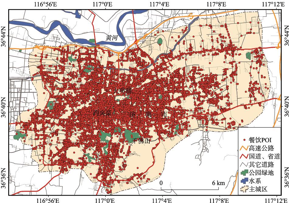
Catering service is an important part of urban life. Extracting urban hotspots for catering services and identifying their spatial distribution patterns is important for our understanding urban space and urban structures. In view of the shortcomings of quantitative analysis of urban morphological features based on POI in the past, the GIS field model was used to identify the spatial distribution patterns of urban feature elements, and the Geo-information Tupu was used to visualize the patterns. Taking the 47100-catering service POIs in the main urban area of Jinan city as the main data source, the catering service hotspots were first extracted based on the density field hotspot detection model and classified according to the density value; then the catering service was expressed by Geo-information-Tupu of generalized symmetric structure and digital field based hierarchical Geo-information Tupu. The spatial distribution structure characteristics and scale structure features of the hotspots are presented, and their Geo-information Tupu of distribution pattern is constructed. Finally, the results are discussed. Research shows that: (1) The digital field hotspot detection model can effectively identify hotspots in different levels from POI. (2) The Geo-information-Tupu of generalized symmetric structure and digital field based hierarchical Geo-information Tupu can analyze and express the spatial distribution structure and hierarchical structure characteristics of the food hotspot from the aspect of vertical and horizontal of space. In summary, this study provides an effective quantitative analysis method for POI-based urban feature extraction and urban morphology research. The method can also be extended to the extraction, analysis and expression of other urban feature elements.