• Journal of Geo-information Science
  • Vol. 22, Issue 4, 898 (2020)
Yongjun ZHANG*, Xingbei HUANG, and Xinyi LIU
Author Affiliations
  • School of Remote Sensing and Information Engineering, Wuhan University, Wuhan 430079, China
  • show less
    DOI: 10.12082/dqxxkx.2020.190774 Cite this Article
    Yongjun ZHANG, Xingbei HUANG, Xinyi LIU. A Terrain-adaptive Airborne LiDAR Point Cloud Filtering Method Using Regularized TPS[J]. Journal of Geo-information Science, 2020, 22(4): 898 Copy Citation Text show less
    Seed point selection and 8-neighborhood region growing
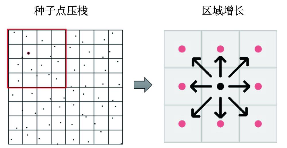
    Fig. 1. Seed point selection and 8-neighborhood region growing
    Errors in region growing of reference points
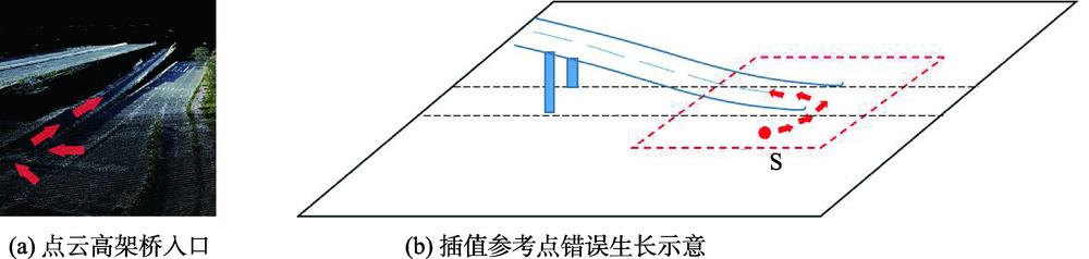
    Fig. 2. Errors in region growing of reference points
    Regions with unreliable reference points
    Fig. 3. Regions with unreliable reference points
    TPS with different regularization coefficient λ
    Fig. 4. TPS with different regularization coefficient λ
    RGB map of original point clouds and binary image of region growing results in site 5
    Fig. 5. RGB map of original point clouds and binary image of region growing results in site 5
    Edge detection results in the part of viaduct connecting to the ground in site 8
    Fig. 6. Edge detection results in the part of viaduct connecting to the ground in site 8
    RGB maps of original point clouds and colored maps of filtering results in Guangzhou sites
    Fig. 7. RGB maps of original point clouds and colored maps of filtering results in Guangzhou sites
    Part of filtering results of ISPRS test sites
    Fig. 8. Part of filtering results of ISPRS test sites
    测区属地测区编号测区地形
    广州1起伏小,含复杂建筑、低矮植被、水体
    广州2起伏较小,含复杂建筑,密集植被等
    广州3起伏小,含复杂建筑、高架桥等
    广州4起伏较小,含大型建筑、密集植被等
    广州5有起伏,含大型建筑、水体、地形断层
    广州6有起伏,含密集植被、建筑和高架桥
    广州7起伏较小,含建筑和植被等
    广州8有起伏,含房屋、电力线,高架桥等
    广州9有起伏,斜坡植被、陡坎、高架桥等
    Vaihingen/StuttgartS11陡坡地物,植被和建筑物等
    Vaihingen/StuttgartS12小型地物,如车辆等
    Vaihingen/StuttgartS21小型桥梁
    Vaihingen/StuttgartS22桥梁
    Vaihingen/StuttgartS23复杂建筑、地形断层
    Vaihingen/StuttgartS24有起伏地形
    Vaihingen/StuttgartS31地形断裂,且包含低点噪声
    Vaihingen/StuttgartS41包含簇状低点噪声
    Vaihingen/StuttgartS42大型长直建筑物,高频率起伏地形
    Vaihingen/StuttgartS51斜坡植被
    Vaihingen/StuttgartS52低矮植被,陡坡和山脊
    Vaihingen/StuttgartS53起伏和中断地形
    Vaihingen/StuttgartS54非显著建筑物
    Vaihingen/StuttgartS61不连续陡坡、沟渠
    Vaihingen/StuttgartS71桥梁,地形断裂
    Table 1. Terrain features in test sites
    测区一类错误率二类错误率总体错误率
    SGFCSFPTDTPS本文SGFCSFPTDTPS本文SGFCSFPTDTPS本文
    13.313.993.464.412.452.904.025.493.423.263.094.004.543.882.88
    23.216.063.174.772.887.286.468.436.427.205.506.296.125.695.30
    32.974.642.013.792.293.053.864.272.493.333.014.233.203.102.83
    43.924.673.354.722.485.006.815.584.315.034.485.784.504.513.80
    52.377.383.813.142.084.123.894.474.114.853.515.114.243.773.88
    62.702.926.234.132.763.385.253.254.862.783.154.454.284.612.77
    74.243.623.222.871.239.7211.539.099.2410.496.486.865.625.475.01
    82.122.292.853.172.114.416.024.352.902.853.294.203.623.042.49
    95.944.933.324.641.625.5312.895.0614.1112.635.719.744.3710.368.27
    平均值3.424.503.493.962.215.046.755.555.765.824.255.634.504.944.14
    Table 2. Comparison of error rate using different filtering methods in Guangzhou sites (%)
    测区SohnAxelsson(PTD)PrefierMongus(TPS)LiChen(MHC)HuiZhang(CSF)本文
    S1120.4910.7617.3511.0112.8513.0113.3412.0111.70
    S128.393.254.505.173.743.383.502.973.40
    S218.804.252.571.982.551.342.213.423.31
    S227.543.636.716.564.064.675.418.945.40
    S239.844.008.225.836.165.245.114.795.47
    S2413.334.428.647.985.676.297.472.872.67
    S316.394.781.803.342.471.111.331.611.53
    S4111.2713.9110.753.716.715.5810.605.145.44
    S421.781.622.645.723.061.721.921.581.91
    S519.312.723.712.593.921.644.883.083.01
    S5212.043.0719.647.1115.434.186.563.934.66
    S5320.198.9112.608.5211.717.297.475.204.67
    S545.683.235.476.733.933.094.163.183.49
    S612.992.086.914.855.811.812.331.492.77
    S712.201.638.853.144.581.333.735.713.08
    平均值9.354.828.025.626.184.115.334.394.17
    Table 3. Comparison of total error rate using different filtering methods in ISPRS test sites (%)
    滤波算法SGFCSFPTDTPS本文
    耗时/(s/每500万点)3.2873.87518.3448.2913.569
    Table 4. Comparison of time costs using different filtering methods in Guangzhou sites
    Yongjun ZHANG, Xingbei HUANG, Xinyi LIU. A Terrain-adaptive Airborne LiDAR Point Cloud Filtering Method Using Regularized TPS[J]. Journal of Geo-information Science, 2020, 22(4): 898
    Download Citation