• Journal of Natural Resources
  • Vol. 35, Issue 2, 371 (2020)
Ya-hui WANG1、2, Er-fu DAI1、2、*, Liang MA1、2, and Le YIN1、2
Author Affiliations
  • 1Lhasa Plateau Ecosystem Research Station, Key Laboratory of Ecosystem Network Observation and Modeling, Institute of Geographic Sciences and Natural Resources Research, CAS, Beijing 100101, China
  • 2University of Chinese Academy of Sciences, Beijing 100049, China
  • show less
    DOI: 10.31497/zrzyxb.20200210 Cite this Article
    Ya-hui WANG, Er-fu DAI, Liang MA, Le YIN. Spatiotemporal and influencing factors analysis of water yield in the Hengduan Mountain region[J]. Journal of Natural Resources, 2020, 35(2): 371 Copy Citation Text show less
    Location and current land use of Hengduan Mountain region
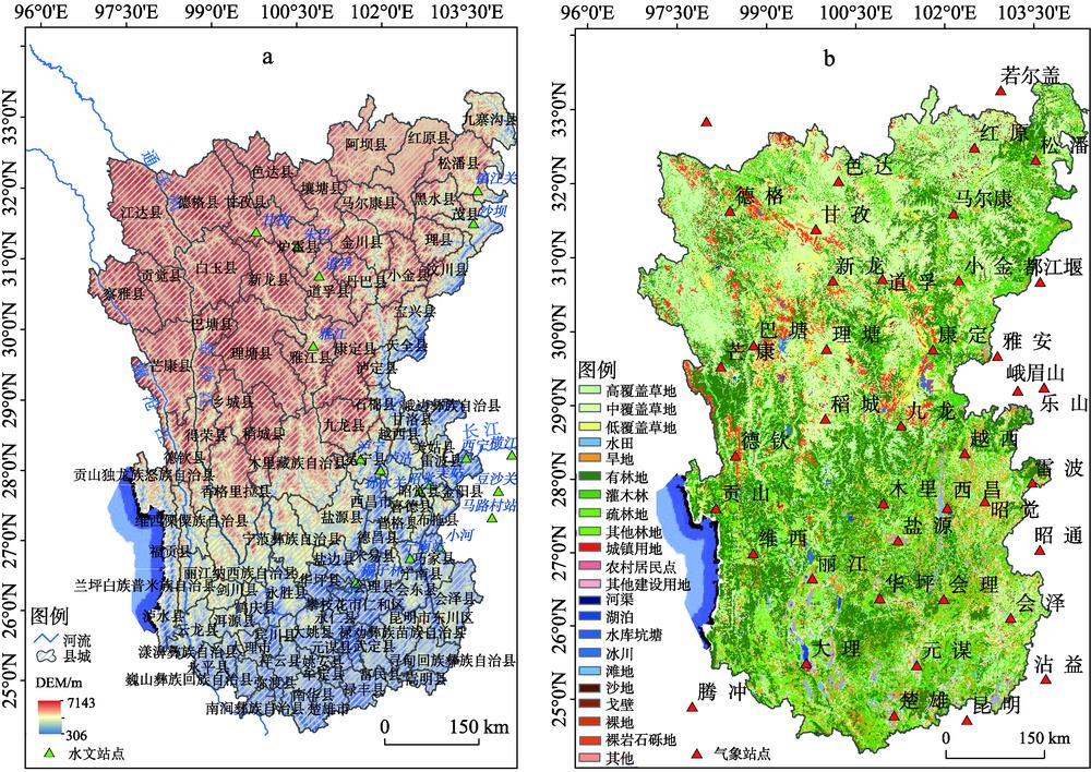
    Fig. 1. Location and current land use of Hengduan Mountain region
    Framework for spatiotemporal distribution and its influencing factors of water yield in Hengduan Mountain region
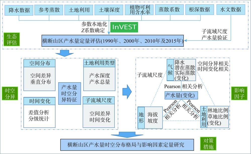
    Fig. 2. Framework for spatiotemporal distribution and its influencing factors of water yield in Hengduan Mountain region
    Comparation of simulated and observed values of water yield in Hengduan Mountain region
    Fig. 3. Comparation of simulated and observed values of water yield in Hengduan Mountain region
    Spatial pattern of water yield in Hengduan Mountain region during 1990-2015
    Fig. 4. Spatial pattern of water yield in Hengduan Mountain region during 1990-2015
    Vertical gradient change of land use and water yield
    Fig. 5. Vertical gradient change of land use and water yield
    Variation of annual average water yield, precipitation and evapotranspiration during 1990-2015 in Hengduan Mountain region
    Fig. 6. Variation of annual average water yield, precipitation and evapotranspiration during 1990-2015 in Hengduan Mountain region
    Spatiotemporal distribution of the water yield variation in Hengduan Mountain region
    Fig. 7. Spatiotemporal distribution of the water yield variation in Hengduan Mountain region
    Variation of average water yield and current total water yield of different land use types in Hengduan Mountain region
    Fig. 8. Variation of average water yield and current total water yield of different land use types in Hengduan Mountain region
    Spatial pattern of water yield on the sub-watershed scale in Hengduan Mountain region
    Fig. 9. Spatial pattern of water yield on the sub-watershed scale in Hengduan Mountain region
    Spatial pattern of precipitation and actual evapotranspiration in Hengduan Mountain region
    Fig. 10. Spatial pattern of precipitation and actual evapotranspiration in Hengduan Mountain region
    时间/年海拔坡度降水量潜在蒸散实际蒸散林地比例草地比例


    2015-0.749**-0.180.942**0.238*-0.380.53**-0.679**
    2010-0.479**0.1450.946**0.0550.0070.479**-0.482**
    2000-0.733**-0.0850.973**0.49**0.0950.625**-0.721**
    1990-0.683**0.0180.961**0.338**0.0600.649**-0.722**
    1990-20100.983**-0.1320.0080.052-0.034
    2000-20100.995**-0.650**0.0530.13-0.173
    2010-20150.995**-0.445**0.2060.181-0.279*
    Table 1. Correlation analysis of average water yield and climate, topography, and land cover in the sub-basins of Hengduan Mountain region
    Ya-hui WANG, Er-fu DAI, Liang MA, Le YIN. Spatiotemporal and influencing factors analysis of water yield in the Hengduan Mountain region[J]. Journal of Natural Resources, 2020, 35(2): 371
    Download Citation