• Journal of Geo-information Science
  • Vol. 22, Issue 4, 857 (2020)
Peijun DU1、1、2、2、3、3、*, Xin WANG1、1、2、2、3、3, Yaping MENG1、1、2、2、3、3, Cong LIN1、1、2、2、3、3, Peng ZHANG1、1、2、2、3、3, and Gang LU2、2、4、4
Author Affiliations
  • 1School of Geography and Ocean Science, Nanjing University, Nanjing 210023,China
  • 1南京大学地理与海洋科学学院,南京 210023
  • 2Key Laboratory for Land Satellite Remote Sensing Applications of Ministry of Natural Resources, Nanjing University, Nanjing 210023, China
  • 2南京大学自然资源部国土卫星遥感应用重点实验室,南京 210023
  • 3Jiangsu Center for Collaborative Innovation in Geographical Information Resource Development and Application, Nanjing 210023, China
  • 3江苏省地理信息资源开发与利用协同创新中心,南京 210023
  • 4Jiangsu Provincial Surveying and Mapping Engineering Institute, Nanjing 210013, China
  • 4江苏省测绘工程院,南京 210013
  • show less
    DOI: 10.12082/dqxxkx.2020.190747 Cite this Article
    Peijun DU, Xin WANG, Yaping MENG, Cong LIN, Peng ZHANG, Gang LU. Effective Change Detection Approaches for Geographic National Condition Monitoring and Land Cover Map Updating[J]. Journal of Geo-information Science, 2020, 22(4): 857 Copy Citation Text show less
    Technical route of change detection method based on statistics of change pixel
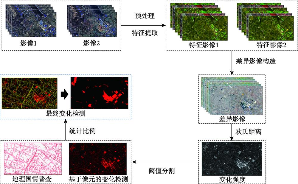
    Fig. 1. Technical route of change detection method based on statistics of change pixel
    Technical route of change detection method based on the pattern of geographic national census
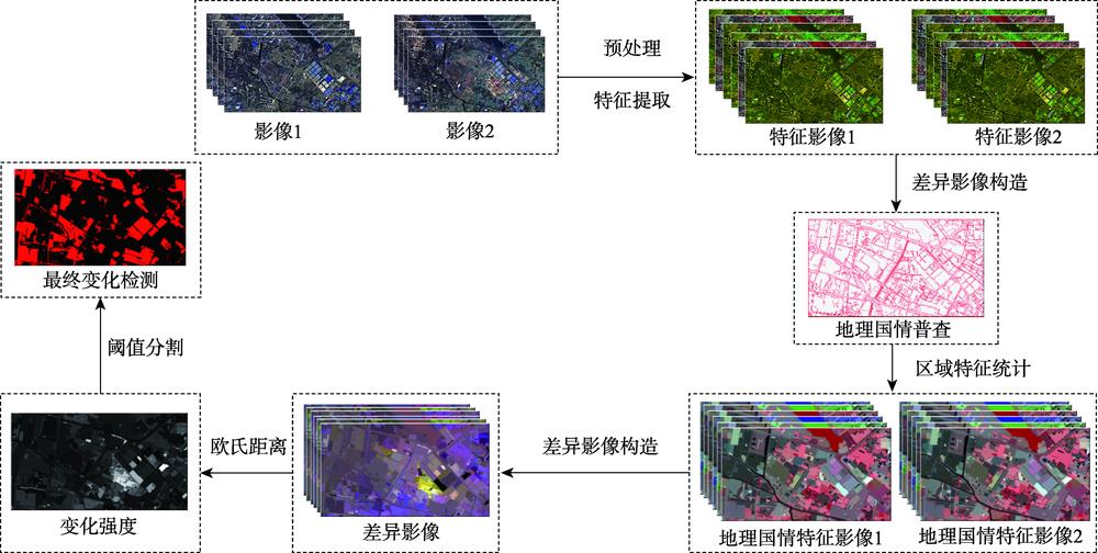
    Fig. 2. Technical route of change detection method based on the pattern of geographic national census
    Technical route of updating geographic national census based on CDE
    Fig. 3. Technical route of updating geographic national census based on CDE
    True color composite remote sensing images, the vectors of geographic national census, and the reference maps of land cover changes in the study areas
    Fig. 4. True color composite remote sensing images, the vectors of geographic national census, and the reference maps of land cover changes in the study areas
    Change detection and change intensity of geographic national census based on statistics of change pixel
    Fig. 5. Change detection and change intensity of geographic national census based on statistics of change pixel
    Change detection map based on the pattern of geographic national census
    Fig. 6. Change detection map based on the pattern of geographic national census
    Updated geographic national census land cover maps based on high-resolution remote sensing image change detection
    Fig. 7. Updated geographic national census land cover maps based on high-resolution remote sensing image change detection
    基于变化像元统计的地理国情变化检测方法基于地理国情普查单元的变化检测方法
    研究区1研究区2研究区1研究区2
    OA/%93.6593.6869.3188.52
    Kappa系数0.54090.61680.13140.3767
    Table 1. Geographic national census based change detection results
    研究区1研究区2
    土地利用类型耕地0.86540.8173
    园地0.91850.7421
    林地0.83810.8377
    草地0.81820.7782
    房屋建筑0.92660.8123
    道路0.95790.9917
    构筑物0.59120.8872
    人工堆掘地0.93360.8006
    水体0.88100.8894
    总体精度0.89960.8613
    Kappa系数0.85980.8383
    Table 2. Accuracy of land cover updating results
    Peijun DU, Xin WANG, Yaping MENG, Cong LIN, Peng ZHANG, Gang LU. Effective Change Detection Approaches for Geographic National Condition Monitoring and Land Cover Map Updating[J]. Journal of Geo-information Science, 2020, 22(4): 857
    Download Citation