• Journal of Natural Resources
  • Vol. 35, Issue 10, 2385 (2020)
Long LI1, Da-fang WU1、*, Yan-yan LIU1, Li TENG1, Zhi-feng WU1, and Zhao-hua FENG2
Author Affiliations
  • 1School of Geography and Remote Sensing, Guangzhou University, Guangzhou 510006, China
  • 2Hunan Second Surveying and Mapping Institute, Changsha 410000, China
  • show less
    DOI: 10.31497/zrzyxb.20201007 Cite this Article
    Long LI, Da-fang WU, Yan-yan LIU, Li TENG, Zhi-feng WU, Zhao-hua FENG. "Double evaluations" of karst area from the perspective of ecological civilization: A case study of Ningyuan in ecologically sensitive area[J]. Journal of Natural Resources, 2020, 35(10): 2385 Copy Citation Text show less
    The study area
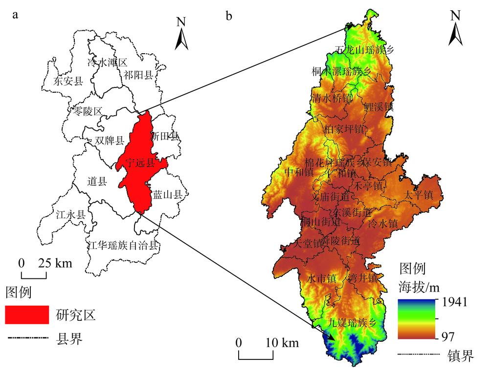
    Fig. 1. The study area
    Evaluation technical route
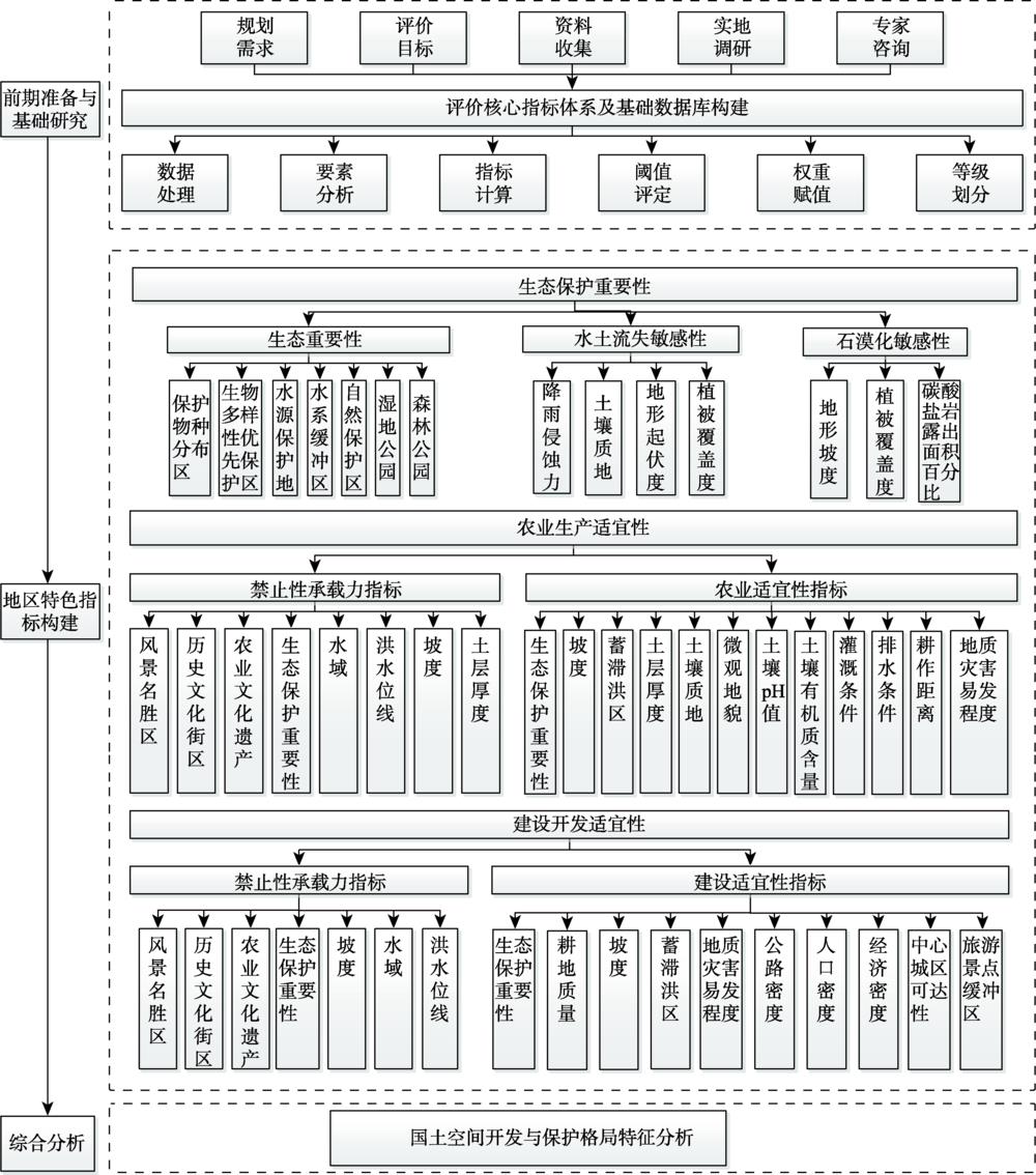
    Fig. 2. Evaluation technical route
    Evaluation of importance of ecological protection in Ningyuan
    Fig. 3. Evaluation of importance of ecological protection in Ningyuan
    Evaluation of suitability of agricultural production in Ningyuan
    Fig. 4. Evaluation of suitability of agricultural production in Ningyuan
    Evaluation of suitability of construction and development in Ningyuan
    Fig. 5. Evaluation of suitability of construction and development in Ningyuan
    Pattern of land space development and protection in Ningyuan
    Fig. 6. Pattern of land space development and protection in Ningyuan
    目标层准则层要素层
    生态保护
    重要性
    生态重要性保护物种分布区(x1)
    生物多样性优先保护区(x2)
    水源保护地(x3)
    水系缓冲区(x4)
    自然保护区(x5)
    湿地公园(x6)
    森林公园(x7)
    水土流失敏感性降雨侵蚀力(x8)
    土壤质地(x9)
    地形起伏度(x10)
    植被覆盖度(x11)
    石漠化敏感性地形坡度(x12)
    碳酸盐岩露出面积百分比(x13)
    植被覆盖度(x11)
    Table 1. Evaluation index system of ecological protection importance
    目标层准则层要素层权重
    农业生产
    适宜性
    禁止性承
    载力指标
    风景名胜区(i1)
    历史文化街区(i2)
    农业文化遗产(i3)
    生态保护重要性(i4)
    水域(i5)
    洪水位线(i6)
    坡度(i7)
    土层厚度(i8)
    农业适宜
    性指标
    生态保护重要性(j1)0.1125
    坡度(j2)0.0872
    蓄滞洪区(j3)0.0756
    土层厚度(j4)0.0963
    土壤质地(j5)0.0854
    微观地貌(j6)0.0768
    土壤pH值(j7)0.0825
    土壤有机质含量(j8)0.0923
    灌溉条件(j9)0.0752
    排水条件(j10)0.0695
    耕作距离(j11)0.0962
    地质灾害易发程度(j12)0.0505
    Table 2. Evaluation index system of agricultural production suitability
    目标层准则层要素层权重
    建设开发
    适宜性
    禁止性承
    载力指标
    风景名胜区(i1)
    历史文化街区(i2)
    农业文化遗产(i3)
    生态保护重要性(i4)
    水域(i5)
    洪水位线(i6)
    坡度(i7)
    建设适宜
    性指标
    生态保护重要性(k1)0.1222
    耕地质量(k2)0.1054
    坡度(k3)0.0854
    蓄滞洪区(k4)0.0872
    地质灾害易发程度(k5)0.0785
    公路密度(k6)0.1002
    人口密度(k7)0.1158
    经济密度(k8)0.1225
    中心城区可达性(k9)0.0925
    旅游景点缓冲区(k10)0.0903
    Table 3. Evaluation index system of construction and development suitability
    生态保护重要性指标度量阈值区间
    IIIIIIIVV
    保护物种分布区(x1)其他县级省级国家级
    生物多样性优先保护区(x2)其他县级省级国家级
    水源保护地(x3)范围外范围内
    水系缓冲区(x4)/km其他干流两侧6~8
    缓冲区
    干流两侧4~6
    缓冲区
    干流两侧2~4
    缓冲区
    干流两侧2
    缓冲区
    自然保护区(x5)其他县级省级国家级
    湿地公园(x6)其他县级省级国家级
    森林公园(x7)其他县级省级国家级
    降雨侵蚀力(x8)≤ 25(25, 100](100, 400](400, 600]>600
    土壤质地(x9)黏壤土砂质壤土、砂质黏土壤土沙壤土沙土
    地形起伏度(x10)/m[0, 20](20, 50](50, 100](100, 300]>300
    植被覆盖度(x11)≥ 0.8[0.6, 0.8)[0.4, 0.6)[0.2, 0.4)<0.2
    地形坡度(x12)/(º)≤ 5(5, 8](8, 15](15, 25]>25
    碳酸盐岩露出面积
    百分比(x13)/%
    ≤ 10(10, 30](30, 50](50, 70]>70
    Table 4. Index classification and valuation of ecological protection importance
    禁止性承载力指标度量阈值区间
    01
    风景名胜区(i1)范围内范围外
    历史文化街区(i2)范围内范围外
    农业文化遗产(i3)范围内范围外
    生态保护重要性(i4)VI~IV
    水域(i5)范围内范围外
    洪水位线(i6)位线以下位线以上
    坡度(i7)/(º)>25≤ 25
    土层厚度(i8)/cm<30≥ 30
    农业或建设适宜性指标度量阈值区间
    20406080100
    生态保护重要性(j1、k1)VIVIIIIII
    坡度(j2、k3)/(º)>25(15, 25](8, 15](2, 8]≤ 2
    蓄滞洪区(j3、k4)重要蓄滞洪区一般蓄滞洪区蓄滞洪保留区非蓄滞洪区
    土层厚度(j4)<30[30, 60)[60, 90)≥ 90
    土壤质地(j5)沙土沙壤土壤土砂质壤土、砂质黏土黏壤土
    微观地貌(j6)山肩、山顶背坡麓坡趾坡、岗地平原、台地
    土壤pH值(j7)≤4.9或≥ 95~85.0~5.4或8.5~8.95.5~5.9或7.9~8.46~7.8
    土壤有机质含量(j8)<1[1, 3)≥3
    灌溉条件(j9)无条件一般满足基本满足
    排水条件(j10)不健全一般健全基本健全
    耕作距离(j11)>89.34(68.03, 89.34](36.07, 68.03]≤36.07
    地质灾害易发程度(j12、k5)高易发区中易发区低易发区其他
    耕地质量(k2)低于平均
    利用等
    高于平均利用等非耕地
    公路密度(k6)/(km/km2)≤ 0.1(0.1, 0.3](0.3, 0.6](0.6, 0.8]>0.8
    人口密度(k7)/(人/km2)≤ 100(100, 300](300, 500](500, 900]>900
    经济密度(k8)/(万元/km2)≤ 100(100, 400](500, 1000](1000, 2500]>2500
    中心城区可达性(k9)/分钟车程>12090<车程≤12060<车程≤9030<车程≤ 60车程≤ 30
    旅游景点缓冲区(k10)/km其他6~8缓冲区4~6缓冲区2~4缓冲区2缓冲区内
    Table 5. Index classification and valuation of suitability of production and development
    适宜区均不
    适宜
    生态单
    适宜
    农业单
    适宜
    建设单
    适宜
    生态、农业
    双适宜
    生态、建设
    双适宜
    农业、建设
    双适宜
    三类均
    适宜
    面积/hm2175.46180839.8155.89126.261460.4029896.40919.3136672.67
    比例/%0.0772.290.020.050.5811.950.3814.66
    Table 6. Statistics of multifunctional spatial suitability zoning
    Long LI, Da-fang WU, Yan-yan LIU, Li TENG, Zhi-feng WU, Zhao-hua FENG. "Double evaluations" of karst area from the perspective of ecological civilization: A case study of Ningyuan in ecologically sensitive area[J]. Journal of Natural Resources, 2020, 35(10): 2385
    Download Citation