• Journal of Geo-information Science
  • Vol. 22, Issue 3, 399 (2020)
Shun CAI, Haopeng GENG*, Weishan ZHENG, and Baotian PAN
Author Affiliations
  • Key Laboratory of Western China's Environmental Systems(Ministry of Education), College of Earth and Environmental Sciences, Lanzhou University, Lanzhou 730000, China
  • show less
    DOI: 10.12082/dqxxkx.2020.190529 Cite this Article
    Shun CAI, Haopeng GENG, Weishan ZHENG, Baotian PAN. Valley Spacing Character Information and Its Influencing Factors based on the Fourier Transform[J]. Journal of Geo-information Science, 2020, 22(3): 399 Copy Citation Text show less
    Locations of the study area and 0.12 m resolution DEM
    Fig. 1. Locations of the study area and 0.12 m resolution DEM
    The terrain frequency characteristic signal about Lanzhou Dalingxian region with 1 m resolution and 75 m×75 m area(wavelength=1/frequency)
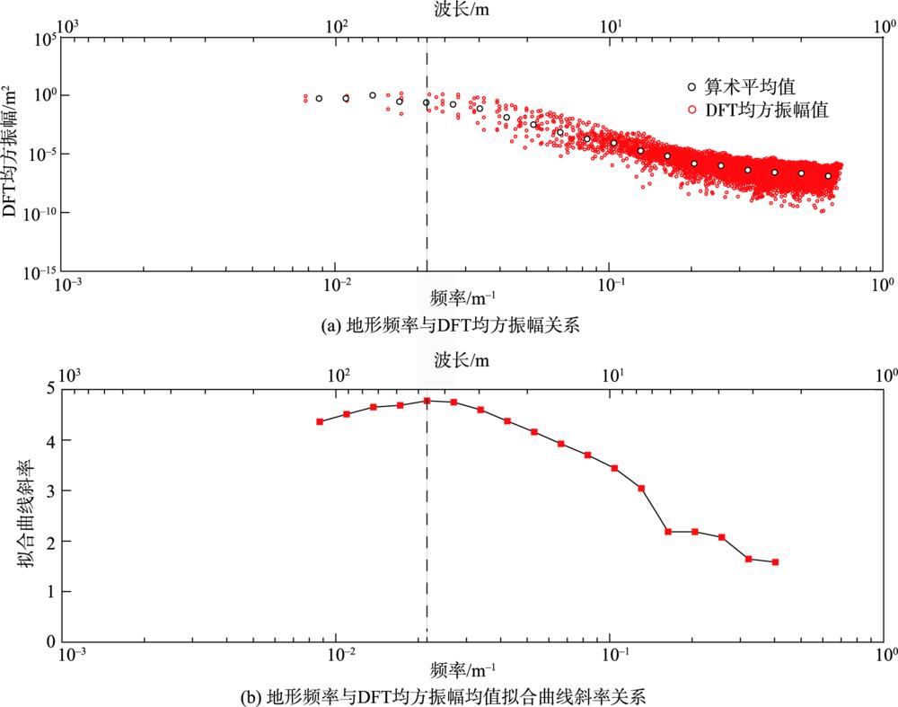
    Fig. 2. The terrain frequency characteristic signal about Lanzhou Dalingxian region with 1 m resolution and 75 m×75 m area(wavelength=1/frequency)
    Comparison of hill shade with different resolution and schematic diagram of valley spacing measurement
    Fig. 3. Comparison of hill shade with different resolution and schematic diagram of valley spacing measurement
    The terrain frequency against the regression line slope about Heihe zhengyixia region with 1-10 m resolution and 650 m×580 m area
    Fig. 4. The terrain frequency against the regression line slope about Heihe zhengyixia region with 1-10 m resolution and 650 m×580 m area
    The terrain frequency characteristic signal about Lanzhou Dalingxian region with different resolution and 1414 m×2071 m area
    Fig. 5. The terrain frequency characteristic signal about Lanzhou Dalingxian region with different resolution and 1414 m×2071 m area
    The terrain distribution ranges about different areas with 1 m resolution
    Fig. 6. The terrain distribution ranges about different areas with 1 m resolution
    The terrain frequency against the regression line slope about different areas with 1 m resolution
    Fig. 7. The terrain frequency against the regression line slope about different areas with 1 m resolution
    性能参数
    GPS模块GPS/GLONASS
    GPS定位悬停水平精度±1.5 m
    GPS定位悬停垂直精度±0.5 m
    传感器有效像素2000万
    镜头FOV 84°8.8 mm/24 mm(35 mm)
    Table 1. Key parameters of DJI Phantom 4 Pro V2.0
    Shun CAI, Haopeng GENG, Weishan ZHENG, Baotian PAN. Valley Spacing Character Information and Its Influencing Factors based on the Fourier Transform[J]. Journal of Geo-information Science, 2020, 22(3): 399
    Download Citation