Jiancheng LUO1,1,2,2, Tianjun WU3,3,*, Zhifeng WU4,4, Ya'nan ZHOU5,5..., Lijing GAO1,1,2,2, Yingwei SUN1,1,2,2, Wei WU6,6, Yingpin YANG1,1,2,2, Xiaodong HU1,1,2,2, Xin ZHANG1,1,2,2 and Zhanfeng SHEN1,1,2,2|Show fewer author(s)
Author Affiliations
1State Key Laboratory of Remote Sensing Science, Aerospace Information Research Institute, Chinese Academy of Sciences, Beijing 100101, China1中国科学院空天信息创新研究院 遥感科学国家重点实验室,北京 1001012University of Chinese Academy of Sciences, Beijing 100049, China2中国科学院大学,北京 1000493School of Geology Engineering and Geomatics, Chang'an University, Xi'an 710064, China3长安大学 地质工程与测绘学院,西安 7100644School of Geographical Sciences, Guangzhou University, Guangzhou 510006, China4广州大学地理科学学院,广州 5100065School of Earth Science and Engineering, Hohai University, Nanjing 211100, China5河海大学地球科学与工程学院,南京 2111006College of Computer Science and Technology, Zhejiang University of Technology, Hangzhou 310023, China6浙江工业大学计算机学院,杭州 310023show less
DOI: 10.12082/dqxxkx.2020.190462
Cite this Article
Jiancheng LUO, Tianjun WU, Zhifeng WU, Ya'nan ZHOU, Lijing GAO, Yingwei SUN, Wei WU, Yingpin YANG, Xiaodong HU, Xin ZHANG, Zhanfeng SHEN. Methods of Intelligent Computation and Pattern Mining based on Geo-parcels[J]. Journal of Geo-information Science, 2020, 22(1): 57
Copy Citation Text
show less
Abstract
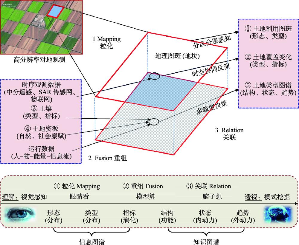
In the era of big data, high-resolution Earth observation technologies have been able to provide the most authentic, quantitative, comprehensive-coverage, and fast-updating data about the geographic phenomena and processes on the Earth's surface. Such data provide precise spatiotemporal benchmarks of information aggregation and computation of data mining for new developments of geospatial cognitive research. Geo-parcels are abstract expressions for mapping geographical entities from image-space to geographic-space. Geo-parcels are the smallest units of pattern mining with the construction of geographic scenes and loading various geospatial information. In this paper, a synergistic calculation mechanism with the machine learning methods of visual simulation and symbol inference were analyzed based on the basic unit of geo-parcels. From the dimensions of space, time, and attribute, we constructed an intelligent computation model based on geo-parcels by integrating three sub-models: zoning-stratified perception, spatiotemporal synergistically inversion, and multi-granular decision-making. Furthermore, this paper explored the pattern mining methods of geo-parcels for their distribution, growth, and function via two case studies: the agricultural planting structure mapping in Xifeng County, Guizhou province and the planning decision in Jiangzhou District of Guangxi Zhuang Autonomous Region.