
Nan WANG, Weiming CHENG, Baixue WANG, Qiangyi LIU, Chenghu ZHOU. Geomorphological regionalization theory system and division methodology of China[J]. Journal of Geographical Sciences, 2020, 30(2): 212
- Journal of Geographical Sciences
- Vol. 30, Issue 2, 212 (2020)
Abstract
1 Introduction
Geomorphology is a basic component of natural environment studying surface morphology of the Earth, which is the carrier of human productivity and life (
Studies on geomor-regions gradually emerged with the development of regional research. Since the 1930s, a large number of studies have been documented that put forward geomor-region schemes of China through compiling various atlases and monographs of geomor-regions (
Based on analysis of similarities and differences in the past and existing research, it was concluded that the geomor-region schemes proposed by predecessors are quite different in various aspects. Firstly, the indicator systems proposed at different times were distinct. Before the 1960s, geomor-regions were divided mainly based on structural landforms. In contrast, after the 1980s, morphological landforms played a dominant role in the geomor-region division. Secondly, the purposes of application were varied in different periods. In the early stage, depiction of the geomorphological characteristics was the priority. However, in recent years, the utilization of resources has become the main trend. Thirdly, the details of regional research were varied spatially. Studies in eastern China have been more comprehensive and verified compared with studies in the western part of China where historical data and materials were limited. In addition to the spatio-temporal discrepancies in the study of geomor-regions, two main deficiencies can be identified from the existing research: (1) the small-scale geomor-region maps do not match with other geographical factors, which weakens the controlling role of the geomorphological boundaries; and (2) the incomplete classification systems, most of which consist of only two or three orders, are not detailed enough to meet the needs of modern environmental and resource planning and decision making. Consequently, the establishment of a complete multi-order geomor-region scheme of China is an extremely necessary and pressing research subject.
In this study, we summed up the existing geomor-region schemes at multiple levels (i.e. national, regional, and provincial), and proposed a new three-order geomor-region scheme on a national scale for the first time. The scheme is composed of three main sections. Firstly, a model for the calculation of division indicators at each order is selected. Secondly, the naming rules and coding methods of geomor-regions at all orders are defined. Finally, a systematic database of the geomor-regions is established. Based on multi-source data, this study presents a precise division scheme of geomor-regions at three orders and provides a more accurate basis and controllable data background for China’s resource utilization, ecology, and environmental management.
2 Theory of geomor-region in China
2.1 Plate tectonics and geomorphological characteristics
At the end of the 20th century, the presentation of the crust plate theory represented a landmark revolution in the history of geomorphological research. The theory analyzed the endogenic forces associated with the differentiation of geomorphic features, and thus explained the linkage mechanism between the characteristics of surface morphology and the tectonic activities of deep crustal plates (
Under the background of global plate tectonic movement, the first- and second-order geomorphic units in China are mostly determined based on geomorphic tectonics. They have undergone many tectonic changes. Some large mountain ranges went through multi-cyclic orogenies. Especially for the Mesozoic, constrained by the Indosinian movement and the Yanshan movement, a tectonic framework corresponding to the modern macro-geomorphological outline of China was established (
The geomorphic layer is distributed on the Earth’s surface, similar as the lithosphere, hydrosphere, and atmosphere, which was proposed in the Encyclopedia of Geomorphology in 1968. The internal structure of the Earth’s crust is mainly determined by endogenic forces, whereas the external morphology is formed by exogenic forces (
2.2 Geomorphological features and forces
2.2.1 Endogenic forces of geomorphology
China is located in the southeast of the Eurasian continental plate, with the western Pacific and Philippine plates to the east and the Indian plate to the southwest (
2.2.2 Exogenic forces of geomorphology
Under the framework control of tectonic landforms formed by endogenic forces, the external morphology of a landform is changed constantly and continuously by exogenic forces. Because of various natural geographical conditions, climate factors play a dominant role in the transformation of landforms, and affect weathering, transport, and accumulation through regional differences in precipitation and temperature (
The classification of geomor-types in China is mostly based on a combination of morphology and genesis (
2.3 Type and regional differentiation of geomorphological morphology
2.3.1 Type differentiation and type structure of geomorphological morphology
In terms of basic morphology, China can be divided into mountain, plateau, hill, basin and plain areas. The areas of mountains and plateaus account for majority of China, followed by basins, while smaller proportions are for hills and plains (
2.3.2 Regional differentiation and regional structure of geomorphological morphology
China’s topography is dominated by mountains and plateaus, and gradually declines from west to east (
3 Research on geomor-regions in China
3.1 Research progress of geomor-regions in China
The study of geomor-regions in China has a history of more than 70 years (
In 1953,
3.2 Main problems for geomor-region study in China
A great deal of work has been carried out on the depiction of geomor-region boundaries in China. However, previous studies were unsatisfactory because of shortcomings in the disunity and inconsistency of the division system, as well as limitations of the cartographic scale and incompleteness of the application function.
3.2.1 Disunity of the division system
The division system refers to the skeleton and the orders of the geomor-region scheme. On one hand, the documented schemes showed divergence in the number of orders. Before 1959, most researchers adopted a two-order scheme. However, after 1959, three-order schemes became predominant (except one released in 2013). On the other hand, the numbers of regions at each order were quite distinct. Before 1959, most studies divided China into three first-order major-regions and approximately 20 second-order sub-regions. However, the Preliminary Draft of China’s Geomorphological Regionalization published in 1959 proposed to divide China into 18 first-order major-regions. In addition, schemes published in 1991 and 2013 divided China into three and six first-order major-regions, respectively. The disunity of the division system indicates that the study of geomor-region in China has failed to organically combine the geological structure system with the geomor-type, resulting in a disunified hierarchical system of geomor-regions.
3.2.2 Inconsistency of the division indicators
Division indicators refer to the influencing factors considered in the process of programming. Through analysis and comparison, it was found that the existing indicator systems of geomor-regions differ considerably. Before the 1960s, tectonic landforms were given the first priority, whereas after the 1980s, morphological landforms were given the first in the scheme. In 1956, Zhou et al. divided Chinese geomorphology according to the geological structure (
3.2.3 Limitation of the cartographic scale
The cartographic scale reflects the details that depicted in geomor-region maps. Historical researches showed great spatial differences in the amount of information and details of the boundaries reflected in geomor-region maps because of the divergence of available data. The vast amount of accessible materials in eastern China, which has detailed division, is in deep contrast with the western part, where available data is sparse, and the division was done more roughly (
3.2.4 Incompleteness of the application function
The application function of geomor-regions has been changing over time. In the early stage, the main application function for geomor-regions was the reflection of geomorphological characteristics (
4 New schemes of geomor-regions in China
4.1 Principles of geomor-regions in China
The principles of geomor-regions are the criteria for studying and dividing geomor-regions, which have been addressed by many predecessors (
4.1.1 Principle of regional differentiation
Geomor-region should objectively reflect the similarities and differences of regional geomorphology. It not only reveals the law of regional spatial differentiation of geomorphology, but also clearly delineates the differences of geomorphological structure from a regional perspective. Therefore, the geomor-region must be continuous, and the same geomor-region can only exist once in space (
4.1.2 Principle of geomorphological genesis
Geomor-region is a kind of geographical zoning with special regional morphology, and should be based on the characteristics of the geomorphology itself. The main object of geomorphological research is the surface morphology and force conditions, and the geomor-region should be based on the similarity between the surface morphology and geomorphological genesis (
4.1.3 Principle of multi-order scheme
Usually, geomor-regions can be divided into two or three orders (
4.2 Methods of naming and coding
The published Chinese geomor-region schemes and achievements of Chinese geomorphic research have laid a solid foundation for drawing up a completed new scheme of Chinese geomor-region on a national scale (
4.2.1 Hierarchical system
China covers a vast territory, with various types of landforms and complex combinations. Restricted by the scale and accuracy, geomor-types and their combinations vary greatly in different regions. Therefore, a hierarchical system is usually adopted in research on national geomorphological regionalization, which means dividing the whole country into several major-regions, and then into several sub-regions and small-regions in turn downwards. From higher to lower orders, the combination of geomor-types is usually from complex to simple, the number of geomor-types in each geomor-region gradually decreases, and the scale of the combination of geomor-types becomes small. Names adopted in previous schemes were not consistent, and need to be standardized for popularization and application (
4.2.2 Naming principles
Considering the uniqueness and non-repeatability of geomor-regions in space, the naming method should follow the following principles. These are: (1) to inherit and retain traditional, reasonable, and recognized names, and to avoid or minimize the use of disputed names as much as possible; (2) naming in sequence according to the order of the first-order major-region, second-order sub-region, and third-order small-region; (3) naming is carried out in the order of place names first, then major geomor-types and their combinations, and then geomor-region orders; (4) place names are divided into administrative regions, macro topographic units, such as mountains, basins, and plateaus, in due order; (5) geomor-types and their combinations are named according to the topmost morphological types in the area; and (6) geomor-regions with similar geomorphological characteristics can be further divided by regional and azimuth names and their combinations, such as the eastern section of Taihang Mountains and the northern foot of Changbai Mountains, which can reflect the location and direction information of the geomor-region.
4.2.3 Coding methods
Following the naming method defined in this paper, the three-order names of geomor-regions are generally too long and are not flexible enough to be used in practical applications. Hence, to facilitate the analysis and statistics of the geographic characteristics in multi-order geomor-regions, a coding method of combining numbers and letters is proposed. The general coding methods and codes of geomor-regions adopted in this paper are given in
| Order | First-order major-region | Second-order sub-region | Third-order small-region |
|---|---|---|---|
| Coding methods | Roman numerals | Capitalized letter in | Arabic numerals |
| Region example | Eastern China plains, low mountains and hills region | Northern and Eastern China plains sub-region | Huang-Huai-Hai alluvial plain small-region |
| Coding example | I | IG | IG4 |
Table 1.
Examples of coding and naming methods of three-order geomor-regions in China
4.3 Calculation of the division indicators
4.3.1 Division lines of geomor-regions
Generally, the distribution characteristics of geomor-types are represented as horizontal and vertical band spectra spatially (
4.3.2 Division indicators of geomor-types
By summarizing the classification methods of various geomor-types at home and abroad,
4.3.3 Division indicators of geomor-regions
Geomor-region represents the regional study of geomorphological characteristics at a regional scale, including endogenic processes dominated by regional geomorphological morphology, regional surface composition, neotectonic movement, exogenic processes reflected by denudation and accumulation, and the history of geomorphological formation and evolution. It is a basic component of geomor-region research, and the main reflection of regional geomorphological similarities and differences.
Based on the macro-geomorphic characteristics of China, three-order geomor-region indicators are proposed, which consist of the terrain ladder characteristics under the control of geo-tectonics by combining the regional macro-morphological types with endogenic and exogenic forces and the basic morphological types. The indicator systems consist of three orders of regions. The first-order major-regions are constrained by the mega-structural geomorphic units. They reflect the differences of mega-contours caused by endogenic forces, such as the macro-patterns of mountains, plateaus, hills, basins, and plains under the control of the three-level terrain ladder in China. The combination of geomor-types controls the differentiation of exogenic forces macroscopically (
The second-order sub-regions are macro-morphological structure characteristics mainly referring to geomorphic units such as mountains, plateaus, hills, basins, and plains formed by exogenic forces, and reflecting the differences of exogenic forces in the region (
The third-order small-regions are combinations of geomorphological characteristics referring to the basic geomorphological spatial combinations dominated by exogenic forces (
4.3.4 Division method of geomor-regions
The first-order major-regions are influenced by global plate tectonics and regional geological structures. China’s terrain has obvious characteristics of a three-level ladder. The first terrain ladder is centered on the Tibetan Plateau, with an average elevation of more than 4,000 m. The second terrain ladder consists of areas from the outer edge of the Tibetan Plateau to the Da Hinggan Mountains, Taihang Mountains, Wushan Mountains, and Xuefeng Mountains, with an overall average elevation of more than 1,000 m, which is mainly composed of vast plateaus, large basins, and many high mountains. The third terrain ladder is the lowest terrain ladder including the vast plains and hills in eastern China. This ladder covers the Northeast China Plain, the Huang-Huai-Hai Plain, the Middle and Lower Reaches of the Yangtze River Plain, and the hills south of the Yangtze River, for which the elevation is generally below 500 m (
According to the scheme of geotectonic division, China is divided into three tectonic units including the geosynclinal fold unit, the platform unit, and the active belt of the continental margin unit (
The second-order sub-regions are controlled by the geotectonic platform, geosyncline, and continental margin active zone resulting from distinct exogenic forces and morphology. China can be divided into two main geomorphic units: (1) denudation-dominated units (mountains, plateaus, and hills) and (2) accumulation-dominated units (plains and basins). Based on the first-order-level geotectonic division and referring to the second-order-level geotectonic division, the second-order geomor-regions were established under the framework of a mountain-plateau-hill assemblage and a plain-basin assemblage. The precise boundaries are depicted based on indicators derived from DEM images and the basic geomor-types.
The third-order small-regions are based on the two types of geomorphic zoning units (second-order sub-regions) of mountain-plateau-hill assemblages and plain-basin assemblages. These regions are refined with the aid of basic morphological types and geomorphic genesis types, and form a combination of denudation-dominated mountain-hill regions and a combination of accumulation-dominated plain regions. The boundaries of the third-order small-regions are a combination of basic geomor-types and basic genesis types based on the multi-scale geomor-type data.
4.4 First-order, second-order, and third-order geomor-region scheme in China
4.4.1 First-order major-region
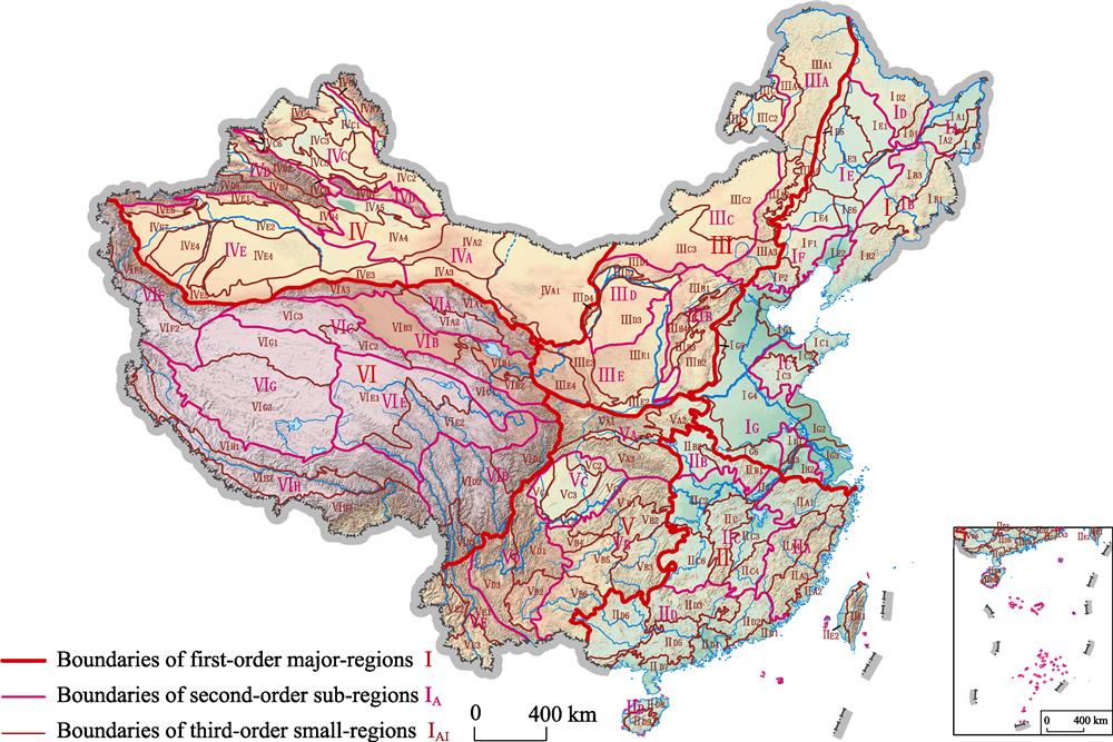
In this paper, we proposed that China is divided into six first-order major-regions, including Eastern China Plains-Low Mountains-Hills Region I, Southeastern China Low Mountains-Hills-Plains Region II, Northern China-Eastern Inner Mongolia Middle Mountains-Plateaus Region III, Northwestern China High and Middle Mountains-Basins-Plateaus Region IV, Southwestern China Middle and Low Mountains-Plateaus-Basins Region V, and the Tibetan Plateau High and Extremely High Mountains-Basins-Valleys Region VI. Among them, Region VI is located on the first terrain ladder in China, Regions III, IV, and V constitute the second terrain ladder, whereas Regions I and II constitute the third terrain ladder.
The first-order division scheme is basically in accordance with Li’s division method (
4.4.2 Second-order sub-region and third-order small-regions
Within the framework of first-order major-regions, some detailed analyses have been performed to obtain 36 second-order sub-regions and third-order small-regions. As a result, the I to VI major-regions were divided into 8, 5, 5, 5, 5, and 8 sub-regions, and 28, 23, 19, 25, 20, and 21 small-regions, respectively (
![]()
Figure 1.
| Second-order sub-regions | Third-order small-regions | ||||||
|---|---|---|---|---|---|---|---|
| Codes | Names | Codes | Names | ||||
| IA | Wanda Mt and Sanjiang Plain low mountains and hills sub-region | IA1 | Sanjiang alluvial plains small-region | ||||
| IA2 | Wanda Mt low mountains and hills small-region | ||||||
| IA3 | Xingkai Lake alluvial-lacustrine plains small-region | ||||||
| IB | Changbai Mt middle and low mountains, platforms and hills sub-region | IB1 | Changbai Mt middle and low mountains, lava platforms small-region | ||||
| IB2 | Eastern Liaoning low mountains and hills small-region | ||||||
| IB3 | Zhangguangcai Mt middle and low mountains and hills small-region | ||||||
| IC | Eastern Shandong low mountains, hills and plains sub-region | IC1 | Jiaodong low mountains and hills small-region | ||||
| IC2 | Jiaolai alluvial plains small-region | ||||||
| IC3 | Central Shandong middle and low mountains and hills small-region | ||||||
| ID | Xiao Hinggan Mt low mountains, hills and | ID1 | Eastern Xiao Hinggan Mt low mountains and hills small-region | ||||
| ID2 | Western Xiao Hinggan Mt hills and lava platforms small-region | ||||||
| IE | Songhua River-Liaohe River Plains sub-region | IE1 | Xiao Hinggan and Dahei Mts piedmont alluvial-diluvial plains and platforms small-region | ||||
| IE2 | Lower reaches of Liaohe River alluvial-marine plains small-region | ||||||
| IE3 | Songhua River-Nenjiang River alluvial-lacustrine plains small-region | ||||||
| IE4 | Upper reaches of Liaohe River diluvial-alluvial plains small-region | ||||||
| IE5 | Eastern foot of Da Hinggan Mts hills small-region | ||||||
| IE6 | Middle reaches of Liaohe River alluvial plains small-region | ||||||
| Second-order sub-regions | Third-order small-regions | ||||||
| Codes | Names | Codes | Names | ||||
| IF | Yanshan Mts & western | IF1 | Western Liaoning hills and platforms small-region | ||||
| IF2 | Yanshan Mt low mountains and hills small-region | ||||||
| IG | Northern and Eastern China plains sub-region | IG1 | Bohai Sea marine plains small-region | ||||
| IG2 | Northern Jiangsu lacustrine-marine plains small-region | ||||||
| IG3 | Jiangsu and Zhejiang alluvial delta plains small-region | ||||||
| IG4 | Huang-Huai-Hai alluvial plain small-region | ||||||
| IG5 | Piedmont of Taihang Mts diluvial-alluvial plains small-region | ||||||
| IG6 | Piedmont of Funiu and Dabie Mts alluvial-diluvial plains small- region | ||||||
| IH | Ningzhen plains, hills and mounds sub-region | IH1 | Chuzhou low mountains, hills, mounds and plains small-region | ||||
| IH2 | Southern Yangtze River hills and plains small-region | ||||||
| IH3 | Nanjing lower reaches of Yangtze River Plains small-region | ||||||
Table 2.
Names and codes of the second-order sub-regions and third-order small-regions of Eastern China Plains-Low Mountains-Hills Region I
| Second-order sub-regions | Third-order small-regions | |||
|---|---|---|---|---|
| Codes | Names | Codes | Names | |
| IIA | Zhejiang and Fujian middle and low mountains, hills and valleys sub-region | IIA1 | Zhejiang and Anhui middle and low mountains, hills and valleys small-region | |
| IIA2 | Zhejiang and Fujian costal low mountains, hills and plains small-region | |||
| IIA3 | Central Zhejiang and Fujian middle and low mountains, hills and valleys small-region | |||
| IIA4 | Wuyi Mt middle and low mountains, hills and valleys small-region | |||
| IIB | Huaiyang low mountains, hills and mounds sub-region | IIB1 | Tongbai and Dabie Mts middle and low mountains and hills small- region | |
| IIB2 | Nanyang Basin low mountains, hills, platforms and plains small-region | |||
| IIC | Middle reaches of Yangtze River low mountains, hills, plains and basins sub-region | IIC1 | Middle reaches of Yangtze River alluvial plains small-region | |
| IIC2 | Jianghan lacustrine-alluvial plains small-region | |||
| IIC3 | Poyang Lake hills, mounds, alluvial-lacustrine plains small-region | |||
| IIC4 | Southern Jiangxi low mountains, hills and basins small-region | |||
| IIC5 | Mufu and Luoxiao Mts middle and low mountains, hills and basins small-region | |||
| IIC6 | Central-southern Hunan middle and low mountains, hills and basins small-region | |||
| IID | Southern China low | IID1 | Eastern Guangdong coastal low mountains, hills, platforms and plains small-region | |
| IID2 | Eastern Guangdong low mountains, hills, parallel ridges and valleys small-region | |||
| IID3 | Nanling Mts middle and low mountains and basins small-region | |||
| IID4 | Pearl River Delta plains small-region | |||
| IID5 | Guangdong and Guangxi low mountains, hills and basins small-region | |||
| IID6 | Western Guangxi karst low mountains, hills and basins small-region | |||
| IID7 | Guangdong and Guangxi coastal hills, platforms and plains small-region | |||
| IID8 | Northern Hainan platforms and plains small-region | |||
| IID9 | Southern Hainan middle and low mountains and hills small-region | |||
| IIE | Taiwan plains and | IIE1 | Eastern Taiwan middle and low mountains and hills small-region | |
| IIE2 | Western Taiwan low mountains, hills and plains small-region | |||
Table 3.
Names and codes of the second-order sub-regions and third-order small-regions of Southeastern China Low Mountains-Hills-Plains Region II
| Second-order sub-regions | Third-order small-regions | |||
|---|---|---|---|---|
| Codes | Names | Codes | Names | |
| IIIA | Da Hinggan Mt middle and low mountains sub-region | IIIA1 | Northern Da Hinggan Mt middle and low mountains and hills small-region | |
| IIIA2 | Southern Da Hinggan Mt middle and low mountains and hills small-region | |||
| IIIA3 | Northwestern Hebei middle and low mountains small-region | |||
| IIIA4 | Da Hinggan Mt west slope low mountains and hills small-region | |||
| IIIB | Shanxi middle and low mountains and basins sub-region | IIIB1 | Northern Shanxi middle and low mountains and basins small-region | |
| IIIB2 | Taihang Mt middle and low mountains and hills small-region | |||
| IIIB3 | Central-southern Shanxi basins small-region | |||
| IIIB4 | Lvliang Mt middle and low mountains and hills small-region | |||
| IIIC | Northeastern Inner | IIIC1 | Hulun Buir plateau small-region | |
| IIIC2 | Xilin Gol plateau small-region | |||
| IIIC3 | Ulanqab high plain small-region | |||
| IIID | Ordos Plateau and Hetao Plains sub-region | IIID1 | Yinshan Mt middle and low mountains small-region | |
| IIID2 | Hetao alluvial plains small-region | |||
| IIID3 | Ordos Plateau small-region | |||
| IIID4 | Helan Mt subalpine mountains small-region | |||
| IIIE | Loess Plateau sub-region | IIIE1 | Northern Shaanxi loessic ridges, tablelands and mounds small-region | |
| IIIE2 | Fenhe and Weihe diluvial-alluvial plains and platforms small-region | |||
| IIIE3 | Liupan Mt middle and low mountains, hills and valleys small-region | |||
| IIIE4 | Gansu middle mountains, loessic ridges and mounds small-region | |||
Table 4.
Names and codes of the second-order sub-regions and third-order small-regions of Northern China-Eastern Inner Mongolia Middle Mountains-Plateaus Region III
| Second-order sub-regions | Third-order small-regions | |||
|---|---|---|---|---|
| Codes | Names | Codes | Names | |
| IVA | Inner Mongolia, Gansu and Xinjiang plateaus, hills and plains sub-region | IVA1 | Alxa plateaus, hills, aeolian plains small-region | |
| IVA2 | Mazong Mt middle mountains and hills small-region | |||
| IVA3 | Hexi Corridor alluvial-diluvial plains small-region | |||
| IVA4 | Gaxun Gobi hills and basins small-region | |||
| IVA5 | Turpan-Hami alluvial-diluvial plains small-region | |||
| IVB | Altai Mt high and middle mountains sub-region | IVB1 | Altay Mt high and middle mountains small-region | |
| IVB2 | Altay Mt low mountains and hills small-region | |||
| IVC | Junggar Basin sub-region | IVC1 | Ulungur and Ertix rivers alluvial plains small-region | |
| IVC2 | Eastern Junggar Basin hills and plains small-region | |||
| IVC3 | Gurbantunggut Desert small-region | |||
| IVC4 | Western Junggar middle mountains and hills small-region | |||
| IVC5 | Southern margin of Junggar Basin diluvial-alluvial plains small-region | |||
| IVC6 | Tianshan Mt north piedmont low mountains, hills and plains small-region | |||
| Second-order sub-regions | Third-order small-regions | |||
| Codes | Names | Codes | Names | |
| IVD | Tianshan Mt high mountains and basins sub-region | IVD1 | Eastern Tianshan Mt high mountains small-region | |
| IVD2 | Northern Tianshan Mt high mountains small-region | |||
| IVD3 | Central Tianshan Mt high mountains and basins small-region | |||
| IVD4 | Yanqi Basin small-region | |||
| IVD5 | Southern Tianshan Mt high mountains small-region | |||
| IVE | Tarim Basin sub-region | IVE1 | Baicheng front range hills and basins small-region | |
| IVE2 | Northern Tarim River lacustrine-alluvial plains small-region | |||
| IVE3 | Southeastern margin of Tarim River alluvial-diluvial platforms and plains small-region | |||
| IVE4 | Taklimakan Desert aeolian dunes small-region | |||
| IVE5 | Southern margin of Tarim River alluvial-diluvial plains small-region | |||
| IVE6 | Keping front range hills and basins small-region | |||
| IVE7 | Kashgar diluvial-alluvial plains small-region | |||
Table 5.
Names and codes of the second-order sub-regions and third-order small-regions of Northwestern China High and Middle Mountains-Basins-Plateaus Region IV
| Second-order sub-regions | Third-order small-regions | |||
|---|---|---|---|---|
| Codes | Names | Codes | Names | |
| VA | Qinling-Daba Mts middle and low mountains sub-region | VA1 | Qinling Mts middle and high mountains small-region | |
| VA2 | Southern Henan and Hanzhong middle and low mountains, hills and valleys small-region | |||
| VA3 | Daba Mt middle and low mountains and valleys small-region | |||
| VB | Hubei-Guizhou-Yunnan middle and low mountains and valleys sub-region | VB1 | Western Hubei plateau-Dalei Mt middle and low mountains, hilly plateaus and valleys small-region | |
| VB2 | Wuling Mt middle and low mountains and valleys small-region | |||
| VB3 | Xuefeng Mt middle and low mountains small-region | |||
| VB4 | Southern Sichuan-Northern Guizhou-Eastern Yunnan karst plateaus and middle mountains small-region | |||
| VB5 | Central Guizhou karst middle mountains, hilly plateaus and basins small-region | |||
| VB6 | Southern Guizhou-southeastern Yunnan karst plateaus and middle mountains small-region | |||
| VC | Sichuan Basin | VC1 | Eastern Sichuan parallel low mountains, ridges and valleys small-region | |
| VC2 | Northern Sichuan Basin low mountains and hills small-region | |||
| VC3 | Central Sichuan Basin hills and platforms small-region | |||
| VC4 | Western Sichuan Basin alluvial plains small-region | |||
| VC5 | Southern Sichuan Basin low mountains and hills small-region | |||
| VD | Southwestern Sichuan and Central Yunnan | VD1 | Wumeng and Liangshan Mts middle and high mountains small-region | |
| VD2 | Central Yunnan karst plateaus middle mountains and valleys small-region | |||
| VD3 | Yanyuan and Chuxiong plateaus middle mountains and basins small-region | |||
| VE | Southwestern Yunnan middle and high | VE1 | Southern Hengduan Mt middle and high mountains small-region | |
| VE2 | Western Yunnan middle mountains and basins small-region | |||
| VE3 | Southwestern Yunnan middle mountains and valleys small-region | |||
Table 6.
Names and codes of the second-order sub-regions and third-order small-regions of Southwestern China Middle and Low Mountains-Plateaus-Basins Region V
| Second-order sub-regions | Third-order small-regions | |||
|---|---|---|---|---|
| Codes | Names | Codes | Names | |
| VIA | Altun & Qilian Mts high mountains and valleys sub-region | VIA1 | Northern Qilian Mt high mountains and valleys small-region | |
| VIA2 | Southern Qilian Mt high mountains, valleys and basins small-region | |||
| VIA3 | Altun Mt high and extremely high mountains small-region | |||
| VIB | Qaidam Basin and Yellow River-Huangshui River high mountains and basins sub-region | VIB1 | Yellow River and Huangshui River valleys and basins small-region | |
| VIB2 | South of Yellow River high mountains and basins small-region | |||
| VIB3 | Qaidam Basin small-region | |||
| VIC | Central and eastern Kunlun Mt high mountains sub-region | VIC1 | Eastern Kunlun Mt high mountains small-region | |
| VIC2 | Eastern segment of central Kunlun Mt high mountains and plateaus small-region | |||
| VIC3 | Western segment of central Kunlun Mt high mountains and lake basins small-region | |||
| VID | Hengduan Mt high | VID1 | Daxue-Minshan Mt extremely high and high mountains small-region | |
| VID2 | Northern section of Hengduan Mt high mountains and valleys small-region | |||
| VID3 | Southern section of Hengduan Mt high mountains and valleys small-region | |||
| VIE | Sources of Three Rivers high hilly mountains and plateaus-upper reaches of rivers mountains and | VIE1 | Sources of Yangtze, Yellow and Lancang rivers hilly mountains and plateaus small-region | |
| VIE2 | Upper reaches of Three Rivers high mountains and valleys small-region | |||
| VIF | Karakorum & western Kunlun Mt high and | VIF1 | Western Kunlun Mt high and extremely high mountains small-region | |
| VIF2 | Karakorum Mt high and extremely high mountains, broad valleys and basins small-region | |||
| VIG | Qiangtang Plateau lakes and basins sub-region | VIG1 | Hoh Xil plateau hilly mountains and plateaus and lake basins small-region | |
| VIG2 | Qiangtang Plateau high and extremely high mountains and lake basins small-region | |||
| VIH | Himalayan high and | VIH1 | Nyainqentanglha and Gangdise Mts high and extremely high mountains small-region | |
| VIH2 | Northern Himalayas and Yarlung Zangbo River high mountains, valleys and basins small-region | |||
| VIH3 | Himalayan extremely high and high mountains small-region | |||
Table 7.
Names and codes of the second-order sub-regions and third-order small-regions of the Tibetan Plateau High and Extremely High Mountains-Basins-Valleys Region VI
5 Application of geomor-regions in China
5.1 Farmland conversion
Landforms affect the allocation of surface water, heat, soil, and organisms to a significant extent, and thus may have great influence on the type of land use and the structure of farmland.
5.2 Natural hazards
The topographic features of watersheds, including elevation, slope, aspect, etc., have a close relationship with natural hazards, such as flash flooding, debris flows, and landslides.
5.3 Urban development
The geomorphologic environment provides the underlying surface and foundation for urban development, and profoundly impacts urban regional structures, forms, landscapes, and functions (
6 Conclusion
Geomorphological regionalization (geomor-region) and geomorphological type (geomor-type) classification are the two core components of geomorphological research. Many schemes have been proposed for the division of geomor-regions in China. However, there are still some shortcomings in the various documented schemes, such as disunity of the division scheme, inconsistency of division indicators, limitations of mapping scales, and incompleteness of application functions. Under the background of the Geographical and National Conditions Census in China, new requirements are put forward for a new geomor-region scheme with multiple orders on a national scale. In this paper, a complete three-order geomor-region division scheme and a systematic division method were established for the first time. The main progress and conclusions are as follows.
The complete three-order geomor-region division scheme of first-order major-regions, second-order sub-regions, and third-order small-regions in China on a national scale was proposed. In addition, a three-order division indicator system was established including the terrain ladder characteristics under the control of geo-tectonics, the combination of regional macro-scale geomor-types, and the combination of endogenic and exogenic forces and basic geomor-types.
Geotectonics was organically combined with geomor-types to complete the transformation from regional combination of geomor-types to geomor-regions. In addition, based on multiple sources of data, precise location technology, naming rules definition, and a coding method for the multi-order geomor-region scheme were discussed.
The division of the three-order geomor-regions in China has been completed including six first-order major-regions, 36 second-order sub-regions, and 136 third-order small-regions. A national database of geomor-regions has been established.
Research on geomor-region is a comprehensive and generalized complex work. Research findings in this study will promote the development of geomor-regions in China. However, some difficulties and challenges in several aspects still exist, such as the establishment of division scheme, the selection of division indicators, the demarcation of boundaries, and the application of results (
References
[1] H X Chai, C H Zhou, X Chen et al. Digital regionalization of geomorphology in Xinjiang. Journal of Geographical Sciences, 19, 600-614(2009).
[2] Z M Chen. The Chinese Geomorphological Regional Planning Maps. In: The Editorial Committee of Agricultural Resources and Regional Planning of China. Chinese Agricultural Resources and Regional Planning(1991).
[3] Z M Chen. General Geomorphic Map of Land and Sea of Asia and Surrounding (1:8000000)(2012).
[4] W M Cheng, A M Bao, H X Chai et al. Geomorphological Patterns and Effects in Xinjiang(2018).
[5] W M Cheng, X Y Gao, T Ma et al. Spatial-temporal distribution of cropland in China based on geomorphologic regionalization during 1990-2015. Acta Geographica Sinica, 73, 1613-1629(2018).
[6] W M Cheng, Q Y Liu, S M Zhao et al. Research and perspectives on geomorphology in China: Four decades in retrospect. Journal of Geographical Sciences, 27, 1283-1310(2017).
[7] W M Cheng, S M Zhao, Q H Ye et al. Patterns and Dynamics of Frigid Landforms in the Tibetan Plateau(2017).
[8] W M Cheng, C H Zhou. Research and compilation of the Geomorphologic Atlas of the People’s Republic of China (1:1000000). Journal of Geographical Sciences, 21, 89-100(2011).
[9] W M Cheng, C H Zhou. Methodology on hierarchical classification of multi-scale digital geomorphology. Progress in Geography, 33, 23-33(2014).
[10] W M Cheng, C H Zhou, B Y Li et al. Structure and contents of layered classification system of digital geomorphology for China. Journal of Geographical Sciences, 21, 771-790(2011).
[11] W M Cheng, C H Zhou, B Y Li et al. Geomorphological regionalization theory system and division methodology of China. Acta Geographica Sinica, 74, 839-856(2019).
[12] W M Cheng, C H Zhou, Y C Shen et al. Retrospect and perspective of geomorphology researches in China over the past 40 years. Acta Geographica Sinica, 72, 755-775(2017).
[13] C T Diao. The geomorphological environment and urban expanding in Chongqing. Journal of Southwest Teachers University, 15, 484-490(1990).
[14] . Earth Science: A Review and Prospect at the Turn of the Century(2002).
[15] . The Geomorphologic Atlas of People’s Republic of China (1:1000000)(2009).
[16] X Y Gao, W M Cheng, N Wang et al. Spatio-temporal distribution and transformation of cropland in geomorphologic regions of China during 1990-2015. Journal of Geographical Sciences, 29, 180-196(2019).
[17] General Part of Northeast Geomorphological Regionalization (Draft): Changchun(1964).
[18] G Y Gong. Geomorphological Regionalization of Huang-Huai-Hai Plain. Beijing: Institute of Geography, Chinese Academy of Sciences(1985).
[19] Z L Guo, G F Cui. Geomorphologic regionalization of China aimed at construction of nature reserve system. Acta Ecologica Sinica, 33, 6264-6276(2013).
[20] . Geomorphological Mapping Specifications of 1:1000000 in China(1987).
[21] . Atlas of Tibetan Plateau(1990).
[22] X M Jin, Y Li, B L Fu et al. Spatiotemporal characteristics of wetland to farmland conversion processes in different geomorphological divisions during 1954-2015: A case study in the Sanjiang Plain north of the Wanda Mountains. Acta Ecologica Sinica, 37, 3286-3294(2017).
[23] B Y Li, B T Pan, W M Cheng et al. Research on geomorphological regionalization of China. Acta Geographica Sinica, 68, 291-306(2013).
[24] S G Li, W Y Zhang. Geology of China(1953).
[25] Z Q Li, X L Liu. Geomorphic regionalization and agricultural evaluation of geomorphic features in Gansu. Journal of Gansu Agricultural University, 4, 444-449(1994).
[26] Z Z Li. Geomorphic environment and urban construction of Urumqi city. Arid Land Geography, 15, 46-53(1992).
[27] K Liu, X C Wang, T Q Ling. Study on characteristics of highway geological disasters and third physiognomic regionalization in Guangxi. The Chinese Journal of Geological Hazard and Control, 20, 74-79(2009).
[28] Q Y Liu, W M Cheng, D Y Sun et al. Distribution characteristics of historical mountain flood in China. Journal of Geo-information Science, 19, 1557-1566(2017).
[29] H G Pamsay, M I Huber. The Techniques of Structural Geology(1987).
[30] J S Ren, Z X Wang, B W Chen et al. The Tectonics of China from a Global View: A Guide to the Tectonic Map of China and Adjacent Regions(1999).
[31] . Geomorphological Regionalization of China (the first draft)(1959).
[32] Y C Shen. The discussion on geomorphological compartment. Geography, 33-41(1961).
[33] M A Summerfield. Geomorphology and Global Tectonics. UK: John Wiley & Sons Ltd(2000).
[34] L Y You, J C Yang. Geomorphology in China(2013).
[35] M Zhao, W M Cheng, Q Y Liu et al. Spatiotemporal measurement of urbanization levels based on multiscale units: A case study of the Bohai Rim Region in China. Journal of Geographical Sciences, 26, 531-548(2016).
[36] M Zhao, W M Cheng, C H Zhou et al. Spatial differentiation and morphologic characteristics of China’s urban core zones based on geomorphologic partition. Journal of Applied Remote Sensing, 11, 016041(2017).
[37] C H Zhou. A Dictionary of Geomorphology(2006).
[38] C H Zhou, W M Cheng, J K Qian. Digital Geomorphological Interpretation and Mapping from Remote Sensing(2009).
[39] C H Zhou, W M Cheng, J K Qian et al. Research on the classification system of digital land geomorphology of 1:1000000 in China. Journal of Geo-Information Science, 11, 707-724(2009).
[40] T R Zhou, Y F Shi, S P Chen. A draft for topographic regionalization of China. In: Chinese Geography Record. Physical Compartmentalization Draft of China(1956).

Set citation alerts for the article
Please enter your email address
© Copyright 2018-2021 | Chinese Laser Press. All Rights Reserved 沪ICP备15018463号-20