
Mingxing CHEN, Longwu LIANG, Zhenbo WANG, Wenzhong ZHANG, Jianhui YU, Yi LIANG. Geographical thoughts on the relationship between ‘Beautiful China’ and land spatial planning[J]. Journal of Geographical Sciences, 2020, 30(5): 705
- Journal of Geographical Sciences
- Vol. 30, Issue 5, 705 (2020)
Abstract
Keywords
1 Introduction
The concept of ‘Beautiful China’ is a crucial strategic idea and task proposed in the Report of the 18th National Congress of the CPC in 2012. It is also a new way to achieve the Two Centenary Goals and the Chinese dream of great national rejuvenation. This concept also aims to realize the comprehensive and effective development of economy, politics, culture, society, and ecology. In May 2018, General Secretary Xi Jinping clearly outlined the timetable and road map for building a Beautiful China at the National Conference on Environment Protection. He outlined that ‘to ensure that by 2035, the ecological environment quality will be fundamentally improved and the goal of Beautiful China will be basically achieved and that by the middle of the 21st century, humans and nature will live in harmony, the modernization of national governance systems and capacity in the field of ecological environment will be realized in an all-round way for a Beautiful China’ (
The May 2019
The construction and land spatial planning involved with the ‘Beautiful China’ concept have become two important themes closely related to geographic development. These themes provide great opportunities for the development of geography, especially human and economic areas. Construction and land spatial planning underlying ‘Beautiful China’ are currently newly emerging; this means that the academic community has not coalesced around our unified understanding of ‘Beautiful China’ and land spatial planning. There are currently few documents available to analyze the organic relationship between ‘Beautiful China’ and land spatial planning. This paper therefore proposes a new cognitive concept of the goal of ‘Beautiful China’ and land spatial planning and provides a theoretical basis for land spatial planning that can be strengthened in future work. This paper presents a methodological framework for land spatial planning and aims to provide theoretical and methodological support in this area as well as new ideas aiding the construction of ‘Beautiful China.’
2 The concept of ‘Beautiful China’ is the leading national second centenary development goal
2.1 The Two Centenary Goals and construction of ‘Beautiful China’
Subsequent to founding of the People’s Republic of China in 1949, remarkable development achievements have been made and the country has entered into a new era of socialism with specific national characteristics. In order to realize this Chinese Dream, the government put forward “The Two Centenary Goals” which aim to complete building a moderately prosperous society by the time the Communist Party of China celebrates its centenary in 2021. The goal is therefore to also turn China into a modern socialist country that is prosperous, strong, democratic, culturally advanced, harmonious, and beautiful by the time the People’s Republic of China celebrates its centenary in 2049. In light of developmental changes, Chinese national strategy made a number of key changes in terms of realistic needs, developmental stage and goal as well as ideas and spatial governance (
| Category | 1949-early 21st century | The new era with socialist characteristics | |
|---|---|---|---|
| New goals | New changes | ||
| Facing different needs | Mainly solve problems to do with food, clothing, and a prosperous life | The desire for a better life | Eat well and enjoy a high-quality life |
| Developmental stage succession | Emphasis on industrial civilization | Realizing ecological civilization | Respecting nature and that clear waters and lush mountains are invaluable assets. Adhering to green development |
| Upgrading of development goals | Focus on economic growth and providing a richer material basis | Constructing ‘Beautiful China’ | Multi-dimensional development and advocating people-oriented economic, social and ecological goals |
| Changing developmental thought | High-speed economic growth in all regions | Different regional functions in regions | Adapting to local conditions and seeking optimized, key, restricted, and prohibited development |
| Changing spatial governance | Strip and multi-head management of land and space | Overall planning and management of land and space | Overall planning of ‘production-living- ecological’ spaces to realize the modernization of space management |
Table 1.
New goals and changes with socialist characteristics
2.2 The concept of ‘Beautiful China’ represents not only ecological beauty but also a comprehensive connotation of ‘great beauty’
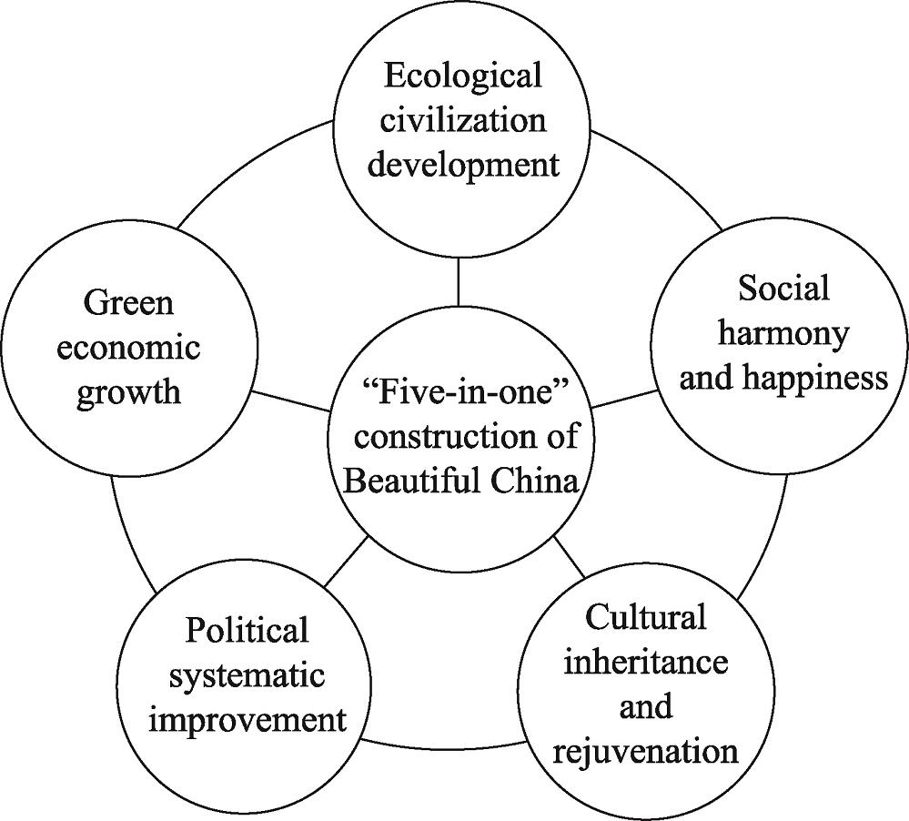
Subsequent to the proposal of the ‘Beautiful China’ concept, all levels of national government have successively strengthened the work of ecological environmental protection and undertaken environmental pollution prevention and control, ecological and urban restoration, and human settlement improvements. These innovations have created a construction mode of ‘Beautiful China’ encompassing local characteristics such as ‘beautiful Zhejiang’ (
![]()
Figure 1.The ‘five-in-one’ construction goal of ‘Beautiful China’
2.3 In order to build ‘Beautiful China’, it is necessary to create an index evaluation system encompassing different scales and regions
The rapid development of industrialization and urbanization within China has also led to a number of ‘urban diseases’ such as ecological damage (
![]()
Figure 2.Construction outline to ‘adapt measures to local conditions,’ part of the ‘Beautiful China’ concept
As part of the process of building ‘Beautiful China’ across different spatial scales, authorities at the state level should strengthen top-level design and organizational leadership and issue instructive strategic planning and phased policy documents to their subordinates. Similarly, at the provincial level, it is necessary to formulate an implementation outline for the construction of ‘Beautiful China’ in order to take the lead in the development of this concept. At the city level, specific action plans should be formulated that encompass the overall layout of multi-element beautiful construction, while at the county level, it is necessary to actively implement the construction plan and create model areas within the ‘Beautiful China’ concept. Finally, it is necessary to comprehensively promote ‘Beautiful China’ construction at the township level in order to ensure that these areas become the birthplace for this dream. Significant differences in the natural background of different regions must also be kept in mind during the process of building ‘Beautiful China’, and the ‘Beautiful China’ construction is supposed to have different focuses.
3 Land spatial planning reform: Relationship with the ‘Beautiful China’ concept
3.1 Changing from multi-management to a blueprint to realize multi-disciplinary land and spatial planning
The purpose of land spatial planning is to coordinate the sustainable development of regional space as well as to prevent and control imbalances and the disordered development spatial structures (
![]()
Figure 3.Compilation system of land and spatial ‘multi-compliance and integration’ planning within the ‘Beautiful China’ concept
3.2 Land spatial planning is one important way to realize the modernization of space governance under the guidance of the ‘Beautiful China’ goal
The ‘Beautiful China’ concept encapsulates the new goals and development vision of Chinese modernization in the new era. This concept therefore guides important land spatial planning decisions nationally in order to meet people’s desires for a better life. Thus, land spatial planning is one important way in which ‘Beautiful China’ goals will be met, it provides a significant mechanism and space guarantee for ‘Beautiful China’ construction. One of the most important ways to measure Chinese capacity and governance level is to scientifically formulate land spatial planning and promote ‘Beautiful China’ construction (
![]()
Figure 4.The relationship between the ‘Beautiful China’ concept and land spatial planning
3.3 Transition from the extrapolation of historical data models to the prediction of planning objectives based on the key goals of ‘Beautiful China’ and the historical data analysis
The concept of land space is a massive and dynamic human-land relationship system that encompasses interactions between human factors such as population, society, economy, innovation, globalization, and infrastructure with natural factors such as the ecological environment, water and land resources, energy, the environment, and climate (
4 The geographical theory and cognitive basis underlying the ‘Beautiful China’ concept and the land spatial planning
4.1 Regional human-land relationship
The material basis that underlies land spatial planning is the effective coordination of a harmonious, pluralistic, and orderly human-land relationship. This means that entire components of the human-land relationship must be considered for overall planning and management. The Academician Wu Chuanjun (1979) proposed a regional system theory for the human-land relationship and pointed out that this system actually comprises a dynamic and complex giant that consists of the interactions between the geographical environment and human activities (
4.2 The point-axes system
Point-axis system theory was first proposed by Mr. Lu Dadao, a famous Chinese human geographer, at the ‘National Symposium on Economic Geography and Land Planning’ that was held in 1984 in Urumqi. Subsequently, based on long-term research and in-depth practical experience of Chinese macro-regional development, Academician Lu further elaborated on ‘the formation process of the point-axis spatial structure,’ ‘the structure and type of the development axis,’ ‘the gradual diffusion of the point-axis,’ and ‘the point-axis-aggregation area.’ He published a series of research articles and developed a complete theoretical understanding of the point-axis system (
4.3 Major functional area theory
The theory of a major functional area is one of the most important guiding ideologies underpinning Chinese land spatial planning. Thus, on the basis of the comprehensive carrying capacity of resources and the environment, the density of land spatial development, and the potential for future planning and utilization in different regions, geographers recognize four types of potential land development, i.e., optimized development, key development, restricted development, and forbidden development areas (
4.4 Sustainable development and resources and environmental carrying capacity
The concept of sustainable development was first defined by the World Commission on Environment and Development as ‘meeting the needs of the present without affecting the needs of future generations’ (
4.5 New urbanization
A significant amount of attention was paid in the past to the urbanization process in order to accelerate it at the expense of quality (
4.6 A multi-system in rural areas
A regional system for urban and rural areas was proposed across China in 2008; this system elaborated on the coupling of urban and rural systems and emphasized the transformation of rural areas as well as the integration of urban and rural development (
5 The framework of land spatial planning: A geographic perspective
In light of the vision and goals of the ‘Beautiful China’ concept, it is important to discuss just how China can achieve land spatial planning to optimize the allocation of resources? A number of clear traditional advantages underpin the important role of geography in land spatial planning. The geography includes physical geography, human geography and geographic information system (including remote sensing, etc.) from the perspective of three parts, while mainly consists of spatial, regional and comprehensive thinking from the perspective of geography classical thinking. These methods are of great significance to land spatial planning. Indeed, in terms of geographical thought and related areas, this paper puts forward a clear land spatial planning framework (
![]()
Figure 5.A geographic land spatial planning framework
![]()
Figure 6.Main components of a land spatial planning framework
5.1 The land and space natural background: Double evaluation of resource carrying capacity, environment, and the suitability of land and space development
In this new era, the premise and foundation of spatial planning is to clarify the natural background of land and space. This means it is necessary to develop a comprehensive understanding and evaluation system for natural resource endowments, ecological service functions, the geographic environmental carrying capacity, and other multi-element background features of land and space. The carrying capacity of resources and the environment as well as resource endowments and ecological conditions means that we can clarify the limitations and suitability of land development and propose the ‘double evaluation’ method (i.e., the evaluation of resource and environmental carrying capacity as well as the suitability of land and space development) for land spatial planning. The ‘double evaluation’ method can then be used to analyze resources as well as the environment and ecology of the land and spatial system in order to perform a comprehensive evaluation encompassing human activities. This approach enables us to accelerate our basic work including delimiting ecological protection red lines as well as those for the permanent basic protection of farmland and the three control lines that mark the boundaries of urban development.
5.2 The socioeconomic basis of land and space: The intensity of land development and a model and stage for socioeconomic development
In addition to natural background, the socio-economy refers to human activities that must be regulated in the context of land spatial planning. Land spatial patterns are therefore a comprehensive reflection of the interaction and coupling of natural resources, the environment, and the socioeconomic system. Subsequent to Chinese reform and opening-up, the development of urbanization and industrialization has continued to increase alongside land and spatial development. At the same time, contradictions between socioeconomic development and resource and environmental protection have become increasingly intense (
5.3 Land-space interactions: Flow space interactions, a cross-regional input-output table, and further applications
In light of the rapid development of economy and society in China as well as continuous progress in transportation technology, connections between different cities and regions have become ever closer. Thus, as part of the land-space planning process, we must fully consider the impacts of flow space interactions on land space. This will enable us to break the current emphasis on scale and the past level of physical space utilization in order to create conditions for the complete flow of elements. An input-output table is therefore useful because it reveals the mechanisms of industrial connections in different regions and can also be utilized to quantitatively explore the influence of flow spatial organization on the total elements of land and space. Thus, by analyzing the characteristics of openness, liquidity, complexity, and the dynamics of pedestrian, logistics, information, and capital flow spatial organization we can improve spatial flow and the allocation efficiency of regional elements. This will also enable us to construct a coordinated, orderly, rapid, and efficient land spatial contact network (
5.4 Vision and path of land spatial planning: The vision and development path design of land spatial planning
In order to achieve our goal of comprehensively optimizing land space, planning in this area should rely completely on our scientific understanding of natural background, the socio- economy, and land space regional connections. This will then enable us to propose a layout and overall development plan for production, living, and ecological space in urban and rural areas across different spatial scales. Land spatial planning must therefore be combined with the overall goal and phased goals of the ‘Beautiful China’ concept and, as such, will focus on the high-quality development requirements of both land and space. Proposing a short-, medium-, and long-term multi-stage developmental vision of land spatial planning at different scales and levels will mean that this process can be applied to design scientific and reasonable space development paths and create a new pattern comprising ‘production-living- ecological’ spaces, ‘intensive and efficient production space, livable and moderate living space, and beautiful ecological space.’
5.5 Public participation and dynamic evaluation: Public participation and the evaluation, feedback and correction of planning
As part of the process of land spatial planning, it is important to emphasize scientific ideas, innovation, and public participation. These feedbacks will enable us to adhere more closely to the scientific decision-making mode led by the government, guided by experts, and including public participation. It is therefore necessary to encourage the public to participate in land spatial planning and to provide evaluation services regarding effects. Thus, by widely seeking ‘public wisdom’ and coordinating ‘public interest,’ we are able to work together to create a scientific and efficient land spatial planning process. Efforts have to date been focused on establishing national, provincial, municipal, and county-level ‘land spatial planning committees.’ In order to gather the planning functions of each department, China must be responsible for the preparation, declaration acceptance, conflict coordination, supervision, and management of land spatial planning and to conduct ongoing dynamic supervision and evaluation of the content, progress, and effects of planning implementation. We aim to expand the channels for the public to apply for spatial planning in order to ensure that everyone can gradually become an important supervisor, promoter, and assessor of spatial planning.
5.6 An intelligent decision-making system for land spatial planning: Big data technology and intelligent spatial planning
Big data applications were applied first in the social sciences (
6 Discussion
The ‘Beautiful China’ concept combined with land spatial planning are major developments in geographic science. Scientific and technological support for relevant strategic demands also need to be strengthened, however, and numerous aspects will require further exploration.
(1) The ‘Beautiful China’ concept is a new national development goal within the confines of ecological civilization. This idea therefore reflects a number of new features as well as the requirements of Chinese socialism in the new era. This concept is thus essentially different from the simple pursuit of quantity and scale that was seen in the past and mainly emphasizes ‘people’s desire for a better life’. It is therefore important to not only coordinate the relationship between ecological protection and socioeconomic development, but also to change the past development model that was driven by scale and to explore a new one based on green development. It is also necessary to pay attention to the meso- and micro-scale of ‘Beautiful China’ as well as land spatial planning in order to plan the construction of high-quality community life circles that are closely related to the lives of people. A number of aspects will also require further study including the definition of connotations and extension of the ‘Beautiful China’ concept. It will also be important to take into account the historical context of ideological evolution, interpretation of the road map of ‘Beautiful China’ construction, and the practical promotion of differentiated samples in various regions.
(2) The concept of ‘Beautiful China’ and land spatial planning are two closely related concepts. It is therefore impossible to discuss land spatial planning without also incorporating the large-scale goals of ‘Beautiful China,’ and vice versa. It is necessary to combine the ‘Beautiful China’ concept with land spatial planning and strengthen our comprehensive understanding of their relationship.
(3) Land spatial planning cannot be separated from quantitative analysis and also cannot be subsumed into econometrics. It is therefore necessary to carry out quantitative data analyses but also to emphasize professional knowledge and experience. This will enable us to study and evaluate major problems and laws in socioeconomic development as well as in land and space. The combination of these two methods will enable us to develop more scientific land spatial planning.
(4) The land and the sea need to be fully included in planning. Thus, coordination between these two environments should be strengthened while blue land spatial planning should be highly valued. China has a long coastline and a vast sea area, so the inclusion of coastal areas should speed up the implementation of special spatial planning for marine territories and promote the construction of beautiful oceans.
(5) The current land spatial planning system used across China is mainly based on administrative regions at all levels as this aids preparation and implementation. The land spatial planning framework must be open-ended, and seek refinements as well as the scientific basis for land reform and space governance on global and larger regional spatial scales. It is therefore important to promote land spatial planning across administrative regions including unified concepts within the Yangtze River Economic Belt. The integrated development of urban agglomerations in this area are deeply connected within this river basin
(6) The construction of ‘Beautiful China’ and the compilation of land spatial planning are in urgent need of interdisciplinary and multi-domain integration as well as innovations in theoretical methods and practical exploration. The Chinese Academy of Sciences has taken the lead in launching a ‘Class-A strategic leading science and technology project’ called the ‘science and technology project for the construction of Beautiful China’s ecological civilization.’ Our goal is to provide effective scientific and technological support for national ecological civilization as well as for the construction of ‘Beautiful China.’ Geographical science, especially human and economic branches of this subject, will play a key role because of inherent discipline characteristics and tradition. At the same time, however, the development of geographic science needs to face up to realistic strategic demands of land spatial planning in order to further contribute in terms of subject value, the expansion of social services, and the consolidation of science and technology resources.
7 Conclusions
(1) The concept of ‘Beautiful China’ and land spatial planning are closely related to one another and provide unprecedented opportunities for geographic sciences. The aim of this article was therefore to discuss this concept, specifically emphasizing the fact that ‘Beautiful China’ is a comprehensive idea that encompasses ‘economy, politics, culture, society and ecology.’ The construction of ‘Beautiful China’ therefore requires a differentiated evaluation index system based on different scale objectives and regional characteristics. At the same time, land spatial planning will require innovations in planning methodologies that encompass interdisciplinary integration. The ‘Beautiful China’ concept is an important goal in spatial planning while land spatial planning itself provides an important mechanism to realize the modernization of space governance in this context.
(2) Land spatial planning provides a clear national foundation and is also novel. Thus, in order to be successful, it is necessary to strengthen our in-depth discussions at the theoretical level with regard to regional human-land relationships, the point-axis system, major functional division, new-type urbanization, and the development of urban agglomerations.
(3) This article proposes a new framework for land spatial planning. This kind of planning should encompass at least six aspects, specifically a natural background for land and space, socioeconomics, connections among regions, a vision and path for land spatial planning, public participation and dynamic assessment, and an intelligent decision-making system that is based on big data technology.
References
[1] et alOur Common Future. New York:Springer(1987).
[2] Big data application in China’s smart city planning. International Urban Planning, 29, 9-11(2014).
[3] Economical and intensive use of land and resources and the transformation of resource utilization methods promote the transformation of economic and social development. Land and Resources Information, 8-13(2011).
[4] Accelerating urbanization should not become the national strategic choice during “the 12th Five-Year Plan” period: A discussion with Professor CHEN Yu-he. China Soft Science, 1-9(2011).
[5] Research progress and scientific issues in the field of urbanization. Geographical Research, 34, 614-630(2015).
[6] Understanding and analysis of 2017 government work report from view of human and economic geography. Journal of the Chinese Academy of Sciences, 32, 426-434(2017).
[7] Research progress and influence of series of consulting reports of urbanization. Geographical Research, 35, 2015-2024(2016).
[8] et alThe review and prospects of China’s human and economic geography: The overview of “High Level Forum of the Development of Chinese Human and Economic Geography under the Background of Change”. Acta Geographica Sinica, 71, 1456-1471(2016).
[9] Healthy urbanization: A new conception and policy explanation. Human Geography, 26, 56-61(2011).
[10] Urbanization level in China: A retrospect and consideration. Urban Planning Forum, 54-59(2007).
[11] et alCognition and construction of the theoretical connotation of new urbanization with Chinese characteristics. Journal of Geographical Sciences, 29, 1681-1698(2019).
[12] Measuring the employment center system in Shanghai central city: A study using mobile phone signaling data. Acta Geographica Sinica, 71, 484-499(2016).
[13] Comprehensiveness of geography and integrated research on regional development. Acta Geographica Sinica, 59, 33-40(2004).
[15] The strategy of major function oriented zoning and the optimization of territorial development patterns. Journal of Chinese Academy of Sciences, 28, 193-206(2013).
[16] Theoretical innovation in optimization of protection and development of China’s territorial space and coping strategy of 13th Five-year Plan. Proceedings of the Chinese Academy of Sciences, 31, 1-12(2016).
[17] Perspective of China’s spatial governance system after 19th CPC National Congress. Journal of the Chinese Academy of Sciences, 32, 396-404(2017).
[18] The implications of five new development concepts on the main orientation of spatial planning in the 13th Five-Year Plan period. Urban Planning Forum, 10-17(2016).
[22] Quantitative simulation and verification of upgrade law of sustainable development in Beijing-Tianjin-Hebei urban agglomeration. Science China Earth Sciences, 62, 2031-2049(2019).
[23] Discussion on the scientific selection and development of China’s urban agglomerations. Acta Geographica Sinica, 70, 515-527(2015).
[24] Exploration on the theoretical basis and evaluation plan of Beautiful China construction. Acta Geographica Sinica, 74, 619-632(2019).
[27] Big data and their epistemological challenge. Philosophy and Technology, 25, 435-437(2012).
[28] Focusing on reform and innovation to build a beautiful new Fujian: Exploration and practice of promoting the legalization of ecological civilization construction in Fujian province. China Environment Supervision, 32-36(2019).
[29] Empirical research on dynamic mechanism of ecological civilization construction of Zhejiang’s beautiful countryside. Ecological Economy, 34, 218-223(2018).
[30] et alConnotation and evaluation index system of Beautiful China for SDGs. Advances in Earth Science, 34, 75-85(2019).
[31] et alResearch progress and prospect of Beautiful China. Progress in Geography, 38, 1021-1033(2019).
[33] Carrying capacity reconsidered in spatial planning: Concepts, methods and applications. Journal of Natural Resources, 34, 2073-2086(2019).
[34] Collaborative planning shaping places in fragmented societies. Journal of Rural Studies, 14, 269-271(1998).
[35] The theoretical guidance of Xi Jinping’s Two Mountains on the Jiangxi model of Beautiful China. Theory Research, 18-19(2018).
[37] et alSpatiotemporal differentiation and coordinated development pattern of urbanization and the ecological environment of the Beijing-Tianjin-Hebei urban agglomeration. Acta Ecologica Sinica, 39, 1212-1225(2019).
[40] Building a Beautiful China to achieve sustainable development. Economic Research Journal, 48, 17-19(2013).
[41] et alConstruction of the spatial planning system: with discussion of the relationship between spatial palnning, regulation, and natural resources supervision. Urban Planning, 42, 9-17(2018).
[42] “America 2050” strategic spatial planning and its inspiration to China. Geographical Research, 32, 90-98(2013).
[43] Progress in the study of European spatial planning and the inspiration to China. Geographical Research, 27, 1381-1389(2008).
[47] The macro strategy of regional development in China. Acta Geographica Sinica, 42, 97-105(1987).
[48] . Location Theory and Regional Research Methods(1988).
[52] The scientific connotation of pole-axis theory. Scientia Geographica Sinica, 22, 136-143(2002).
[53] Causes of the multiple-planning conflict and principle of multiple-planning integration: reviews of the workshop “land use conflicts and multiple planning integration”. China Geosciences, 29, 3-9(2015).
[55] Coupling measurement and prospect forecast of regional “Beautiful China” construction and tourism industry development: A case study of 11 provinces along the Yangtze River Economic Belt. China Soft Science, 86-102(2018).
[56] Transforming Our World: The 2030 Agenda for Sustainable Development. New York:United Nations(2015).
[57] et alCommentaries: Ecological civilization and “Beautiful China”. Social Sciences in China, 5, 204-205(2013).
[58] et alStrategic framework design for ecological civilization construction in beautiful China. Environmental Protection, 14-18(2012).
[59] et alStudy of the evolution and factors influencing ecological security of the Beijing-Tianjin-Hebei urban agglomeration. Acta Ecologica Sinica, 38, 4132-4144(2018).
[61] . Human-earth Relationship and Economic Layout(2008).
[62] et alGeography interact with big data: Dialogue and reflection. Geographical Research, 34, 2207-2221(2015).
[63] Xi Jinping attended the National Ecological Environmental Protection Conference and delivered an important speech. Website of the Central People’s Government of the People’s Republic of China, 05-19(2018).
[66] Effects of national spatial planning to economic growth in key development areas: Evidence from the planning of Wuhan urban agglomeration. China Population, Resources and Environment, 26, 101-109(2016).
[68] Implement the guiding principles of the 19th National Congress of the CPC to forge ahead into the Beautiful Yunnan. Journal of Southwest Forestry University (Social Sciences), 2, 1-10(2018).
[70] A Review on spatial planning coordination and China’s “coordinated planning”. Journal of Urban Planning, 78-87(2016).
[71] Spatial systematic cognition and ideas on spatial planning system reform. China Land Science, 30, 11-21(2016).
[72] Rethinking human geography in the age of big data. Geographical Research, 34, 803-811(2015).
[73] et al. Innovation of Urban Research and Planning Methods Based on Big Data, 98-113(2015).
[75] Research on methods and approaches of spatial governance. Geographical Research, 38, 2527-2540(2019).
[76] Regional differences of urbanization in China. Urban Planning, 17-21(1983).

Set citation alerts for the article
Please enter your email address
© Copyright 2018-2021 | Chinese Laser Press. All Rights Reserved 沪ICP备15018463号-20