
Yunjie WEI, Lin ZHEN, Bingzhen DU. Effects of Grassland Restoration Approaches in Different Major Function-oriented Zones of the Headwater Region of the Yellow River in China[J]. Journal of Resources and Ecology, 2020, 11(2): 150
- Journal of Resources and Ecology
- Vol. 11, Issue 2, 150 (2020)
Abstract
Keywords
1 Introduction
The headwater region of the Yellow River is one the of the most important water source and ecological barrier regions, since it is part of the Three Rivers Headwater Region (the Yangtze, Yellow and Mekong Rivers) which is located in the north eastern part of the Qinghai-Tibet Plateau and in the upper part of the Yellow River. The ecological environment in this region is fragile and extremely vulnerable, and it provides the ecological security barrier functions of the local and surrounding areas, such as water and soil conservation (
The core part of the Yellow River headwater region lies in Qinghai Province. The General Planning on Ecological Protection and Construction in Qinghai Sanjiangyuan Nature Reserve was approved by the State Council of China in order to solve several problems, such as the cutoff of the Yellow River and alpine grassland degradation. The second phase (2013-2020) of the project covered 22 counties in Qinghai Province and the area affected by the project expanded to 395 000 km2 from only 152300 km2 in the first phase (2005-2010). To achieve the goal of the plan, 22 programs have been designed and implemented, including the Rodent Control, Grain for Green, ‘Black Soil Patch’ Degraded Grassland Control, Ecological Migration, and Grassland Fire Prevention Programs. Due to the continuing overexploitation of natural resources and deterioration of the ecological environment following the implementation of ecological restoration technologies (
The recent studies in the headwater region of the Yellow River have shown that: the overall degradation trend of the ecosystem has not been fundamentally contained, and there are still large areas of degraded grassland, desertification land and rodents and pests (
The objectives of this study are to identify the major restoration approaches adopted by the representative households in the headwater region of the Yellow River, to assess the impacts of restoration programs and approaches on vegetation coverage, and to analyze the socio-economic conditions of the households in different MFOZs. The findings are expected to provide a basis for proposing the most effective restoration approaches and also the evidence for alpine grassland restoration and sustainable regional development.
2 Materials and methods
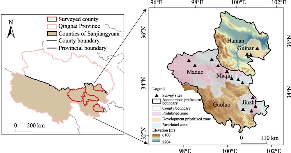
2.1 Study area
The Yellow River is the second largest river in China. The headwater region of the Yellow River contributes approximately 35% of the multi-year mean of the total annual runoff of the Yellow River Watershed, and plays an important role in the overall stability of the river’s water supply and ecosystem conservation (
![]()
Figure 1.Location of study area
- Development prioritized zone: Establish a characteristic agricultural and animal husbandry industrialization base.
- Restricted zone: Establish an important ecological security barrier in the country, and actively develop ecological animal husbandry, ecological tourism and ethnic handicrafts on the plateau.
- Prohibited zone: Protect important areas of natural reserve, historical and cultural resources, and strictly control human interference.
| Major function-oriented zones | County | Towns/villages | Area proportion (%) | Average elevation (m) | Major ecosystem type |
|---|---|---|---|---|---|
| Development prioritized zone | Guinan | Taxiu, Senduo, Guomaying | 11.8 | 3376 | Mountain steppe |
| Restricted zone | Maqin | Dawu, Xiadawu, Dongqinggou | 38.3 | 4279 | Alpine meadow |
| Maduo | Huashixia | ||||
| Jiuzhi | Mentang, Baiyu | ||||
| Prohibited zones | Maqin | Xueshan | 49.9 | 4355 | Alpine meadow |
| Maduo | Zhalinghu, Machali | ||||
| Jiuzhi | Suohurima, Waeryi | ||||
| Total or mean | 4 | 14 | 100 | 4003 | - |
Table 1.
Basic information regarding the study area
2.2 Data and method
2.2.1 Household surveys
Following an initial survey of the literature and discussions with institutional stakeholders, and considering the difficulty in acquiring statistical data for the nomadic area, it was deemed necessary to employ a household survey to collect primary data. Prior to the formal surveys, we conducted an informal, preliminary survey via individual interviews and group discussions with herders and key informants to test our questions, guide the development of the formal questionnaire, and ultimately increase the validity of the results.
We used a stratified random sampling method (
Altogether, 195 households were interviewed, with 51 respondents in Maqin County, 43 in Jiuzhi County, 54 in Maduo County, and 47 in Guinan County, which accounted for 67%-74% of the total households in the respective villages. Our surveys were conducted from July to August 2017. The interviews included questions in the following areas: the socioeconomic characteristics of the household, with questions related to the household composition, levels of education, land and livestock owned, income structure, and consumption; major restoration approaches used; effects of the restoration approaches; perception of grassland recovery; and willingness to participate in grassland conservation projects. We primarily used closed-ended questions, but added open-ended questions when there was an opportunity to expand on certain topics during the interview.
The survey data were analyzed using SPSS software (version 19.0). Specifically, we calculated descriptive statistics and used independent-sample t-tests to identify significant differences between groups.
2.2.2 Spatial data collection and processing
For the purpose of analyzing the changes in vegetation coverage, satellite images from different time periods (
We obtained NDVI images during the growing seasons (from the end of March to August) of each year in Qinghai-Tibetan Plateau from Zhang et al. (2015), then generated annual NDVI data with the maximum value composite method after atmospheric correction and geometric correction using ENVI software. Generally, the regional vegetation fraction coverage (
where
Annual average values of
The vegetation fraction changes from 2000 to 2016 were analyzed using the Raster Calculator of ArcGIS as shown in formula (2):
Δ
where Δ
We also used grassland net primary productivity (NNP) data obtained by using a Carnegie-Ames-Stanford Approach (CASA) model from the Chinese Academy of Sciences.
3 Results
3.1 Grassland restoration approaches in different major function-oriented zones
The household and institution survey identified five ecological restoration technologies that had been adopted in the study areas, i.e., enclosure, grazing prohibition, deratization, grass (perennial herbs) seeding, and crop-forage cultivations (annual herbs) + warm shed. These technologies were combined and applied as five different approaches:
- Approach A: Enclosure only, used by 43 households.
- Approach B: Grazing prohibition, used by 33 households.
- Approach C: A combination of the enclosure and deratization, used by 45 households.
- Approach D: A combination of the enclosure + deratization + grass seeding (perennial herbs), used by 35 households.
- Approach E: A combination of the enclosure + deratization + crop-forage cultivation + warm shed, used by 39 households.
The top three approaches adopted by herders in the development prioritized zone were Approach E (40.4%), Approach C (25.5%) and Approach D (19.1%). Meanwhile, 76.8% of herders in the restricted zone adopted Approach C (28.0%), Approach A (26.8%) and Approach E (22.0%). In the prohibited zone, herders mostly preferred Approach B (34.8%) and Approach A (24.2%). The households in the development prioritized zone owned the least grassland and earned the highest net income, whereas the households in the prohibited zone had the most grassland and the lowest net income (
| Major function- | Approach | Household | Household size | Education level | Area of grassland | Net income |
|---|---|---|---|---|---|---|
| Development | A(5), B(2), C(12), | 47 | 5.9 | 5.2 | 91.7 | 79970.1 |
| Restricted zone | A(22), B(8), C(23), | 82 | 4.9 | 3.4 | 412.6 | 70356.5 |
| Prohibited zones | A(16), B (23), C(10), | 66 | 5.2 | 3.9 | 699.2 | 45736.3 |
| Total or mean | - | 195 | 5.3 | 4.2 | 401.2 | 65354.3 |
Table 2.
Features of households in different MFOZs
3.2 Differences in ecological effects
The trend analysis showed that the grassland coverage increased overall. Out of five classes of vegetation coverage, IV (high) and V (very high) coverage grassland increased from 58.4% to 60.6%, and I (very low) and II (low) coverage grassland decreased from 24.0% to 21.6% during the same period. The average NPP increased from 449.6 g C m-2 yr-1 to 499.2 g C m-2 yr-1.
Spatial variations of the vegetation coverage change were observed among the different MFOZs (
In the restricted zone, 54.8% of households adopted Approaches A and C, and 13.4% adopted Approach E. As a result, 1.4% and 5.8% of the vegetation coverage showed significant and slight decreases, whereas only 2.0% and 15.4% showed significant and slight increases, respectively. The NPP value increased by 6.7%, of which,
In the prohibited zone, NPP increased by 10.0%, and 5.0% and 24.4% of the vegetation coverage showed significant
and slight increases, while 0.6% and 2.7% showed significant and slight decreases, respectively, especially in Zhalinghu Village in Maduo County. The grassland of 83.3% of the households in Zhalinghu was under grazing prohibition (Approach B).
![]()
Figure 2.Vegetation fraction coverage and NPP in different MFOZs
3.3 Differences in economic effect
We used the income of herder households, which indicated herders’ livelihood, to assess the economic effects of the restoration approaches used. The average annual net household income in the study sites was about 65354.3 Yuan household-1 yr-1 (
In the development prioritized zone, the income categories ranked as selling animals (55.8%) 啊啊啊 Tibetan medicine (20.0%) 啊啊啊 others (16.3%) 啊啊啊 subsidy (8.0%). In this zone, 40.4% and 19.1% of households with less grassland adopted Approaches E & D and they got more income from animal husbandry in Guinan County. The income categories of the restricted zone ranked as Tibetan medicine (45.8%) 啊啊啊 selling animals (23.8%) 啊啊啊 others (15.8%) 啊啊啊 subsidy (14.7%), given that about 54.9% of the households which applied Approach A & C and 22.0% which applied Approach D are living in Dawu Town, Xiadawu and Dongqinggou Village of Maqin County and Mentang and Baiyu Village in Jiuzhi County, where the medicinal plants of cordyceps and fritillaria (
![]()
Figure 3.The structure of herder incomes in different zones
3.4 Differences in social effect
We built the indicator system for evaluating the social effect on restoration according to the household survey data (
and cost of the restoration approach. The indicator system indicated the behavior and perception of herders for protecting and restoring grassland. The results showed that the overall social effect was the best in the development prioritized zone, where the scores were the highest for four dimensions but not for the awareness of grassland restoration.
| Indicator | Score level | ||||
|---|---|---|---|---|---|
| 1 | 2 | 3 | 4 | 5 | |
| Participation level of herders involved | None | All invested by government | Materials invested by government and self-employment | Self-investment sometimes | Self-mobilization and self-investment |
| Satisfaction with restoration approachesa | Very poor | Slightly poor | Moderate | Slightly well | Very well |
| Awareness of restoration | No understanding | Less understanding | Moderate understanding | Better understanding | Understanding very well |
| Willingness to participate in restoration | No willingness | / | Willingness for government investment | / | Willingness for self-investment |
| Cost of restorationb (Yuan household-1 yr-1) | < 1000 | 1001-3000 | 3000-5000 | 5000-10000 | 啊啊啊 10001 |
Table 3.
Evaluation and score standards of social effect on restoration
Awareness and satisfaction with restoration from herders in the prohibited zone was higher than that in the restricted zone (
4 Discussion
This study is significant for understanding the effects of restoration approaches and providing a basis for proposing the effective approaches in different MFOZs. The findings of this study also focused on the following four main issues. First, the results showed that vegetation coverage had an overall increase during 2000-2016, however, it was difficult to quantify the effects of climate change (temperature and precipitation) and human activities (grazing and ecological restoration approaches) on the grassland change. Although the existing studies indicated that climate changes played a dominant role in the interannual trends of vegetation productivity in the alpine ecosystems on Qinghai-Tibetan Plateau (
![]()
Figure 4.Social effects on grassland restoration from herders
Second, research on the social and economic effects on grassland restoration has been less prominent than the research on the ecological effects using remote sensing approaches (
Third, the initial goal of MFOZs focuses on the ecological, resource and environmental carrying capacities. This study can explain the facts of better grassland restoration (combined approaches for providing forge and reducing the pressure of grassland), better grassland carrying capacity (smaller grassland and a larger amount of livestock raised) and relatively better ecological and socio-economic effects in the development prioritized zone. It is beneficial to read just the imbalance of regional development that exists in development intensity and future development potential in different regions (
Last, the combined analysis with remote sensing and household survey data can provide significant information for assessing the ecological and socio-economic effects on grassland restoration. The household survey methods focus on the perceptions, attitudes and willingness of local herders who are experienced in managing grassland and animals (
5 Conclusions
Herders applied five approaches to grassland restoration in the study area of the Yellow River headwater region in China. Overall, an increase of vegetation coverage was found from 2000 to 2016. The change in vegetation coverage in the development prioritized zone was the best, and that of the restricted zone was the worst among three zones based on different development goals. The economic and social effects on grassland restoration were quite different in three zones. As with the vegetation coverage, the socio- economic effects of the development prioritized zone were the best out of all three zones. The herder income of the restricted zone was higher than that of the prohibited zone, whereas the awareness and satisfaction scores of grassland restoration of the prohibited zone were higher. Policy makers and grassland managers need to help provide guidance for herders’ business behavior according to the specific development goals.
Appendix
![]()
Figure 5.Fig. S The trend of temperature and precipitation of the study area during 2000-2015 Note: A=Development prioritized zone; B=restricted zone; C= prohibited zone
References
[1] TheDevelopment. Planning of Major Function-oriented Zones in Qinghai Province. Xining: The Development and Reform Commission of Qinghai Province(2014).
[2] FanJ, TaoA, RenQ. On the historical background, scientific intentions, goal orientation, and policy framework of major function-oriented zone planning in China. Journal of Resources and Ecology, 1, 289-299(2010).
[3] Foggin JM. Depopulating the Tibetan grasslands. Mountain Research and Development, 28, 26-31(2008).
[4] Kammer PM, SchobC, EberhardG et al. The relationship between soil water storage capacity and plant species diversity in high alpine vegetation. Plant Ecology & Diversity, 6, 457-466(2013).
[5] Li HX, Liu GH, Fu BJ. Response of vegetation to climate change and human activity based on NDVI in the Three-River Headwaters region. Acta Ecologica Sinica, 31, 5495-5504(2011).
[6] Li MM, Wu BF, YanC et al. Estimation of vegetation fraction in the upper basin of Miyun Reservoir by remote sensing. Resources Science, 26, 153-159(2004).
[7] LiW, ZhaoX, ZhangX et al. Ecosystem changes and their carbon source/carbon sink function on the Tibetan Plateau. Chinese Journal of Nature, 35, 172-178(2013).
[8] LiuJ, ShaoQ, YuX et al. 2016. Comprehensive monitoring and evaluation of terrestrial ecosystems in China..
[9] Lu DD. The several issues regard to China’s regional development strategy and approach. Economic Geography, 29, 2-7(2009).
[10] MaY, ZhouH, ShaoX et al. Recovery techniques and demonstration of degraded alpine ecosystem in the source region of three rivers. Acta Ecologica Sinica, 36, 7078-7082(2016).
[11] . 2016. China Statistical Yearbook of 2016..
[12] Piao SL, Fang JY, CiaisP et al. The carbon balance of terrestrial ecosystems in China. Nature, 458, 1009-1013(2009).
[14] ShaoQ, CaoW, FanJ et al. Effects of an ecological conservation and restoration project in the Three-River Source Region, China. Journal of Geographical Sciences, 27, 183-204(2017).
[15] ShaoQ, FanJ, LiuJ et al. Assessment on the effects of the first-stage ecological conservation and restoration project in Sanjiangyuan region. Acta Geographica Sinica, 71, 3-20(2016).
[16] ShenX, TanJ. Ecological conservation, cultural preservation, and a bridge between: The journey of Shanshui Conservation Center in the Sanjiangyuan region, Qinghai-Tibetan Plateau, China. Ecology & Society, 17, 38-46(2012).
[17] SunH, ZhengD, YaoT et al. Protection and construction of the national ecological security shelter zone on Tibetan Plateau. Acta Geographica Sinica, 67, 3-12(2012).
[18] TianH, LanY, WenJ et al. Evidence for a recent warming and wetting in the source area of the Yellow River (SAYR) and its hydrological impacts. Journal of Geographical Sciences, 25, 643-668(2015).
[20] Weber KE, Tiwari IP. Research and survey format design: An introduction. Bangkok: Asian Institute of. Technology.(1992).
[21] Xiao LS, Zhang GQ, ZhuY et al. Promoting public participation in household waste management: A survey based method and case study in Xiamen city, China. Journal of Cleaner Production,, 144, 313-322(2017).
[22] XuW. The changing dynamics of land-use change in rural China: A case study of Yuhang, Zhejiang Province. Environment and Planning A, 36, 1595-1615(2004).
[23] XueQ, SongWei, ZhangY et al. Research progress in ecological carrying capacity: Implications, assessment methods and current focus. Journal of Resources and Ecology, 8, 514-525(2017).
[24] Yang MY, Dong SK, LiangJ et al. Effect of herder’s decision-making mechanism on the sustainable management of alpine grasslands: A case study of Gonghe and Guinan counties in Qinghai Province. Pratacultural Science, 35, 2039-2048(2018).
[25] YangY, WangJ, LiuP et al. Climatic changes dominant interannual trend in net primary productivity of alpine vulnerable ecosystems. Journal of Resources and Ecology, 10, 379-388(2019).
[26] YangY. Study on ecological carrying capacity of alpine grassland on Qinghai-Tibet Plateau. Master diss. Hebei Normal University(2019).
[27] YaoT, ThompsonL, YangW et al. Different glacier status with atmospheric circulations in Tibetan Plateau and surroundings. Nature Climate Change, 2, 663-667(2012).
[28] Zhang JC. The situation and resource management of cordyceps in Guoluo. Qinghai Prataculture, 12, 33-37(2003).
[29] Zhang XZ, Yang YP, Piao SL et al. Ecological change on the Tibetan Plateau. Chinese Science Bulletin, 60, 3048-3056(2015).
[31] ZhangY, ZhangC, WangZ et al. Quantitative assessment of relative roles of climate change and human activities on grassland net primary productivity in the Three-River Source Region, China. Acta Prataculturae Sinica, 26, 1-14(2017).
[32] ZhaoW, ChenH, LinL et al. Distribution of habitat suitability for different sources of Fritillariae Cirrhosae Bulbus. Chinese Journal of Ecology, 37, 1037-1042(2018).
[35] ZhenL, XieY. Evaluation method and its application of ecological restoration technology for typical ecological vulnerable regions. Acta Ecologica Sinica, 39, 5747-5754(2019).
[36] ZhenL, YanH, HuY et al. Overview of ecological restoration technologies and evaluation systems. Journal of Resources and Ecology, 8, 315-324(2017).
[37] ZhouD, HuangR. Response of water budget to recent climatic changes in the source region of the Yellow River. Chinese Science Bulletin, 57, 2155-2162(2012).
[38] ZhuangQ, HeJ, LuY et al. Carbon dynamics of terrestrial ecosystems on the Tibetan Plateau during the 20th century: An analysis with a process-based biogeochemical model. Global Ecology & Biogeography,, 19, 649-662(2010).

Set citation alerts for the article
Please enter your email address
© Copyright 2018-2021 | Chinese Laser Press. All Rights Reserved 沪ICP备15018463号-20