
Xinhuan ZHANG, Wenqiang XU, Xinyi XIANG, Zhiping ZHANG, Mingjie CUI. Mechanism of interaction between urbanization and resource environment in Central Asia[J]. Journal of Geographical Sciences, 2020, 30(11): 1723
- Journal of Geographical Sciences
- Vol. 30, Issue 11, 1723 (2020)
Abstract
1 Introduction
Urbanization is the process of the non-agricultural transformation of population, industry, and land that has significant impacts on the regional environment. It has different effects on economic development and the resource environment at different scales (
Central Asia is located at the center of Eurasia (
2 Research area and method
2.1 Research area
The study area was Central Asia consisting of five countries: Kazakhstan
Although Central Asia has a vast territory, space suitable for human habitation is limited. In 2017, the total population of the region was 71.30 million, with a density of only 17.78 persons/km2. It is distributed mainly in oases with rich water supply and lush vegetation, and in basins surrounded by high mountains. The gross domestic product (GDP) of the region is 265.20 billion US dollars (USD), accounting for only 0.33% of the world’s GDP (
| Country | Population | Population density | Urbanization rate | GDP | GDP per capita |
|---|---|---|---|---|---|
| Kazakhstan | 18037.78 | 6.68 | 57.34 | 162887 | 9030 |
| Uzbekistan | 32387.20 | 76.13 | 50.55 | 49677 | 1534 |
| Tajikistan | 8921.34 | 64.28 | 26.98 | 7146 | 801 |
| Turkmenistan | 5758.08 | 12.25 | 51.15 | 37926 | 6587 |
| Kyrgyzstan | 6198.20 | 32.32 | 36.14 | 7565 | 1220 |
Table 1.
Overview of the economic and social data for Central Asia (2017)
2.2 Research method
(1) Data sources
The national statistics data were taken from World Bank Open Data. Data on the population and water resources of the states of Kazakhstan were obtained from the
Landsat TM/OLI remote sensing images of the region from 1990 and 2015 were obtained from the website of the United States Geological Survey (USGS). Using ENVI 5.1, the data were preprocessed by false color synthesis and image mosaicking. The images were then preliminarily classified by using eCognition Developer 8.7 based on the sample classification method. Manual visual interpretation was then carried out combined with the empirical data. The land use types in the study area were classified into six categories: woodland, grassland, arable land, water body, urban and built-up land, and the Gobi desert. Using ArcGIS 10.2, the results of classification were calibrated and corrected, and their accuracy was tested. The accuracy of interpretation was 0.87, which met the research requirements.
(2) Indicators
The variation in land use index can reflect the extent and speed of certain types of land use in a period (
where
Urban land compactness is an indicator of spatial patch integrity and aggregation. Typically, the compactness index can indicate the trend of changes in the intensity of urban land use. Urban land compactness is expressed as follows:
where
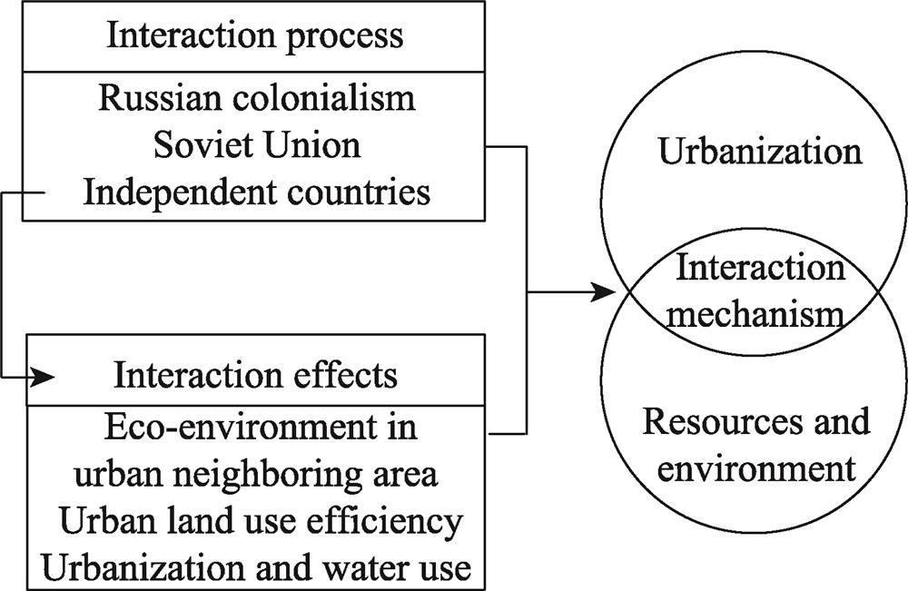
(3) Frame structure
The study focused on the relationship between urbanization and the resource environment in Central Asia. Using process-effect-mechanism as the tool for research, the work here can be divided into three parts. First, the interactions between urbanization and the resource environment in three stages are summarized. Second, the effects of urbanization on the resources and environment of major cities in Central Asia after independence were evaluated. Third, the mechanisms of interaction between them in different stages were obtained (
![]()
Figure 1.
3 Analysis and results
3.1 Process of interaction between urbanization and resource environment
(1) Land conflicts attributed to urbanization during Russian colonialism
From the second half of the 19th century to the beginning of the 20th (1916), Central Asia was under Russian colonial rule. In 1861, Russia abolished serfdom and promoted a settlement policy. There were strong land drivers behind Russian colonial expansion that significantly changed the structure of land and population distribution in Central Asia. In the Kazakh steppe area, a vast expanse of the nomadic land was taken and distributed to the colonizers. In 1917, about 49.05 million ha of land was confiscated by Cossack colonizers, accounting for 20% of the current territory of Kazakhstan. This was used for the construction of fortresses, towns, and roads. The population of the Kazakh steppe in 1897 was 4,147,800, of which the Kazakh population accounted for 81%. By 1914, its population had increased to 5,910,000, of which the Kazakh population accounted for only 65.1%. Russian colonists moved populations and built towns not only in the grasslands, but also in the desert fringes. At present, Russian-style buildings in urban housing can still be seen in farming areas (
Urbanization process in Grassland nomadic-Oasis settlement time was slow, which was accelerated significantly by both the rapidly increasing population and the newly constructed fortresses in Russian colonial process. Natural conditions were still the foundation for the formation of new towns as well as the development of existing cities and towns. Resource-related and environmental problems emerged due to the acceleration of urbanization. First, during colonization, a large number of small towns developed in the north of the Kazakh steppe for the construction of a military fortress line. In addition, arable land surrounding these towns invaded even high-quality grassland. The tension between colonial urbanization and the requirements of the local Kazakh herders for land were this unavoidable. Second, the colonial population was concentrated in Ferghana Valley, and the Syr Darya and Amu Darya Basins, where towns with a better natural environment had been settled for a long time. The rapid growth of population led to pressures on resources and the environment in these towns. Moreover, to meet the demand for cotton in the Russian market, Central Asia was converted into a large-scale cotton-planting area, and a massive amount of water was used. Thus, urbanization in this period began to impose pressures on resources and the environment, and grassland ecosystems were damaged by the development of arable and built-up land.
(2) Deterioration of resources and environment caused by passive urbanization in the Soviet Union
Land reform, agricultural collectivization, land reclamation, and industrial development promoted by the Soviet Union had a dramatic impact on the population, economy, and urbanization in Central Asia. Owing to the dual effects of immigration and a high birth rate, population growth was rapid. In 1985, the total population of Central Asia was 45.47 million, accounting for 16.4% of the population in the Soviet Union. In 1970, it was only 2.9% of the total (
In this period, due to the promotion of the Soviet planned economy, the rapid but low-level urbanization and industrialization had a significant impact on the eco-environment in Central Asia. First, the rapid development of industrialization led to the depletion of certain mineral resources. Serious environmental pollution also occurred in some industrial and mining towns. Second, the industrial and mining towns located in deserts suffered from low water resources. More seriously, large-scale land reclamation and the disorderly expansion of cotton fields in Central Asia began to meet the demands for food and raw cotton in the Soviet Union. In 1980, 95% of raw cotton in the Soviet Union was produced in the Syr Darya and Amu Darya drainage basins. The unrestricted use of the two rivers has led to a sharp reduction in inflows into the Aral Sea. The Aral Sea crisis broke in this period as well, and the surrounding arable land and towns were all affected. Some towns decayed, and the system of resources and the environment supporting urbanization was significantly damaged.
(3) New problems of urbanization and resource environment faced by independent Central Asia
Before and after the dissolution of the Soviet Union, problems kept cropping up in the five countries, such as political emigration, decay of traditional industrial towns, collapse of public service systems, unemployment, and a lack of motivation for economic development. Only Uzbekistan showed a steadily growing trend of urbanization, whereas the other countries in Central Asia exhibited a platform period followed by slow growth and even decline (
![]()
Figure 2.
In this stage, the urban area expanded rapidly and a large number of industrial zones were constructed, which exerted more pressure on the eco-environment. Numerous tensions arose, such as those between a decrease in water resources and an increase in water consumption, the upstream use and the downstream demand for water, and requirements of water for industrial, power generation-related, and irrigation-related uses. Central Asia is among the regions of the world most severely threatened by water shortage (
In this period, due to the emergence of disputes over transnational water resources, the relation between urbanization and the eco-environment became increasingly complicated. On the one hand, the efficiency of utilization of water and land remained low. On the other hand, more water and land were needed to improve urban competitiveness. The transnational water disputes aggravated water-related risks to the urbanization of downstream countries, Uzbekistan and Turkmenistan, where this also put ecological and social security at risk.
3.2 Effects of interactions between urbanization and resource environment
(1) Ecological background of urbanization
Its land cover reflects the regional ecological background of urbanization in Central Asia. In 2015, grasslands accounted for 29.68%, arable land for 14.64%, water bodies for 4.84%, woodlands for 2.16%, urban and built-up land for 1.06%, and deserts accounted for 47.63% of total land.
We show the ecological background for urbanization of major cities under the buffer radius of 50 km (
![]()
Figure 3.
(2) Changes in ecological background in neighboring cities
Variations in land use in the 100 km circle of major cities can reflect both the trends of urbanization and the variation in the eco-environment. Variations in urban land reflects the trend of urbanization, that in arable land reflects the regional response to the available water resources, that in desert land reflects the threats posed by desertification, and the variations in grassland, woodland, and waters reflect the ecological background.
Kyrgyzstan and Tajikistan are mountainous countries, with similar trends of variation in land use in the major neighboring cities. Although urbanization has slowed down since 1990, the expansion of urban land is clear, especially in Tajikistan. Changes in arable and desert land were not significant, and the ratios of grassland, woodland, and water surfaces to the total land have remained constant. Owing to the slow urbanization, the supporting effect of the eco-environment is prominent (Figures 4a and 4b).
![]()
Figure 4.
Uzbekistan and Turkmenistan are located downstream of the Amu Darya, and are characterized by typical oasis urbanization. A total of 63% of the cities have undergone a clear decrease in surrounding arable land, indicating the response of agriculture to the shortage of water resources. As most cities undergoing drastic expansion, those in Fergana Valley have had limited increases in urban land, indicating a constraint on urbanization. A clear decrease in water in the neighboring of towns in Turkmenistan has also been noted, further indicating the increasing pressure on cities downstream of the Amu Darya. (Figures 4c and 4d).
The process of urbanization in Kazakhstan can be divided into two types. For traditional industrial cities in the northeast and Aktau, the urban land expansion index was below 60%, the surrounding arable land decreased in area because it was abandoned, desert land decreased significantly, but there was no clear change in woodland, grassland, and water. For industrial and mining cities in the west, and oases cities in the Syr Darya Basin, the expansion in urban land was drastic, arable land in oases was taken over by urbanization or abandoned, a large area of desert land was used to expand industrial and mining cities, and changes of waters and woodland were obvious. Urbanization with constant motivation exerted obvious impact on neighboring waters, grassland and woodland (Figures 4e and 4f).
(3) Effect of expansion of land for urbanization
The area of urban land in Central Asia increased from 6413.86 km2 in 1990 to 9962.88 km2 in 2015, with an average annual increase of 141.96 km2. The mode of urban land compactness decreased from 0.44 in 1990 to 0.31 in 2015, indicating the general decrease in the compactness of urban land and a disorderly urban sprawl. In this period, the urban land compactness of 47 cities of the region increased from 0.05 to 0.48, of which those of 31 cities decreased, including the national capitals of all five countries (
![]()
Figure 5.
(4) Relationship between urbanization and water resources
An analysis of the relationship between the rate of urbanization, and water intake and the water consumption structure in every state of Kazakhstan and Kyrgyzstan can provide information on the relationship between urbanization and water resources. First, in states with low urbanization rates, water intake was high (
![]()
Figure 6.
![]()
Figure 7.
3.3 Interaction between urbanization and resource environment
(1) Beginning of urbanization
Before Russian colonization, most regions in Central Asia had a nomadic society. Seasonal migration made it difficult to form cities and towns in the grasslands and deserts to the north of Syr Darya, while for agricultural societies scattered in the oases and valleys, early cities and towns were developed in some khanate capitals (
![]()
Figure 8.
![]()
Figure 9.
(2) Period of passive acceleration of urbanization
Russian colonization and the planned economy of the Soviet Union changed the interaction between urbanization and the resource environment. The Kazakh steppe had been dominated by nomadic activities for a long time, and this changed under the impact of a large number of immigrants and the passive settlement of nomads. In this period, numerous fortress towns emerged along with traffic routes in the grasslands. In desert and mountain regions, industrial and mining towns emerged through the promotion of mining. Driven by strong external forces, towns developed on the basis of their mineral resources and exploitation of grassland. They extended from the oases to the deserts and grasslands. Although water was not the decisive factor for urban settlements, near-water features were prominent. With the water channels facilitating the expansion of agriculture land, the area occupied by urban land grew (
(3) Period of active development of urbanization
After the period of economic and social stagnation following the independence of Central Asia from the Soviet Union, the relationships between urbanization and resources, and the environment and the ecology became more complicated. Arable land, once the ecological barrier surrounding urban areas, was turned into grassland or abandoned land, and shrank drastically in area (
4 Discussion
The disorderly competition for natural resources and the continued deterioration of the fragile environment may result in the amplification of risks posed to Central Asia (
(1) Temporal conductivity
Driving factors are different in the three historic stages of urbanization in Central Asia, while the consequences of the former stage may exert influence on the later stages, which was defined as temporal conductivity. Before colonization by Russia, most nations in Central Asia were khanates and the pace of urbanization was slow. From the Russian colonization to the advent of the Soviet Union, passive rapid urbanization in the context of the specific historical background of the region led to massive stress on resources and the environment, the effects of which persist to today. Under Russian colonization and in the Soviet era, the cotton production base in Central Asia supported the industrialization of the Soviet Union at the cost of the consumption of large amounts of freshwater. The mining of mineral resources promoted urbanization but also led to serious pollution. Immigrants further accelerated urbanization, and this contributed to such problems as changes in the grassland ecology and hydrological patterns. The accelerated industrialization owing to military-related demand in the Soviet period led to the imposition of an unreasonable industrial structure and yielded inefficient economic development (
(2) Spatial relevance
The five countries of the region are connected through transnational water systems. Accordingly, the relationship between urbanization and the resource environment have close spatial relevance. It is difficult to resolve the Aral Sea crisis in the current complex international situation. Cities and towns around the Aral Sea are thus declining, and this is affecting the surrounding eco-system. In addition, the traditional means of agricultural development have not yet been upgraded. These factors will lead to further ecological degradation downstream of the Amu Darya and influence urbanization at a larger spatial scale than before. Interestingly, the intensive human activity that has caused the crisis can also be a potential driver to save the Aral Sea (
Water conflicts in local and transboundary regions may worsen in the coming decades owing to the increasing demand for freshwater (
(3) Theoretical contribution and methodological shortcomings
Compared with the literature on urbanization and the resource environment in arid areas, the theoretical contribution of this paper lies in the construction of a model to explain the spatio-temporal conductivity in the dynamic evolution between urbanization, and resources and the environment. In Central Asia, a typical arid area, the impact of urbanization in different historical stages on the resource environment has continued to the present, and the problems related to resources and the environment in local areas are spreading. It is thus important to model this process to understand the complexity of human-environment interaction in this fragile eco-environment area.
There is still much work to be done in the future. It was challenging to obtain data on resources, especially water resources, in these countries. More accurate data are needed to build quantitative model to interpret the relationship between urbanization and resource environment in Central Asia.
5 Conclusions
Based on an analysis of the mechanism of interaction between urbanization and the resource environment in Central Asia, this study yielded the following main conclusions:
(1) In different periods, the interactions between urbanization and the resource environment were different. During Russian colonization, urbanization led to significant land conflicts. About 49.05 million ha of land was confiscated by Cossack colonizers in 1917 and used to construct fortresses, towns, and roads. During passive urbanization in the Soviet Union, the rate of urbanization of the population in Central Asia increased from 17% in 1930 to 45.3% in 1985, and resources and the environment deteriorated. After the fall of the Soviet Union in 1991, the newly independent countries of the region faced numerous problems related to water, land, and the ecology.
(2) The eco-environment of upstream countries in the Syr Darya and Amu Darya basins is relatively stable while resource constraints are notable in downstream countries. The spread of urban land use was significant, and the mode number of urban land compactness decreased from 0.44 in 1990 to 0.31 in 2015, indicating the low level of intensity of land use. The efficiency of utilization of water for urbanization, industrialization, and agricultural development was low, and problems related to water shortage are becoming increasingly serious.
(3) We analyzed the interaction between urbanization and the resource environment in Central Asia in three stages. In the early stage of urbanization, a small number of cities and towns were distributed mainly in oases, adjacent to water sources, and had no significant impact on the eco-environment. During passive urbanization, this distribution extended into deserts, adjacent to water bodies and mineral resources, and occupied a large area of grassland. In this stage, conflicts between urbanization and the available land, and water and the environment began to appear. In the active improvement stage of urbanization, motivations for urbanization differed among countries of the region. Some cities and towns maintained the trend of developing while others decayed. Low-level urbanization led to issues related to the abuse of water and land as well as the pollution of the eco-environment. Transnational conflicts for water also threatened the urbanization in the downstream countries.
References
[1] AbuduwailiJ, MaL. Overview of Central Asian Environments, 237(2015).
[2] AdleC. History of Civilizations of Central Asia•VI (First), 20-41(2017).
[5] ChenX, JiangF Q, WangY J et al. Characteristics of the eco-geographical pattern in arid land of Central Asia. Arid Zone Research, 30, 385-390(2013).
[7] CuiX G, FangC L, LiuH M et al. Assessing sustainability of urbanization by a coordinated development index for an Urbanization-Resources-Environment complex system: A case study of Jing-Jin-Ji region, China. Ecological Indicators, 96, 383-391(2019).
[8] DanielK. Environmental changes in Central and East Asian drylands and their effects on major river-lake systems. Quaternary International, 475, 91-100(2018).
[9] DengM J, LongA H, ZhangY et al. Assessment of water resources development and utilization in the five Central Asia countries. Advances in Earth Science, 25, 1347-1356(2010).
[10] FangC L. Hexi Corridor: Oasis supports urbanization! Discussion with Mr. Zhong Weizhi. Journal of Desert Research, 23, 128-130(2003).
[11] FangC L, CuiX G, LiG D et al. Modeling regional sustainable development scenarios using the urbanization and eco-environment coupler: Case study of Beijing-Tianjin-Hebei urban agglomeration, China. Science of the Total Environment, 689, 820-831(2019).
[12] GrollM, OppC, KulmatovR et al. Water quality, potential conflicts and solutions: An upstream-downstream analysis of the transnational Zarafshan River (Tajikistan, Uzbekistan). Environmental Earth Sciences, 73, 743-763(2015).
[13] HeQ. Investigation on Climate Change in Central Asia, 1-6(2016).
[14] HuR J, JiangF Q, WangY J et al. Central Asia (five countries) arid ecological geographical and environmental characteristics. Arid Zone Research, 31, 1-12(2014).
[15] HuW J, LiuH L, BaoA M et al. Influences of environmental changes on water storage variations in Central Asia. Journal of Geographical Sciences, 28, 985-1000(2018).
[16] . The History of the Soviet Nation-State Construction (Volume II), 511-525(1997).
[17] LiJ L, BaoA M, ChenW et al. Stressed Resources and Environment in the Context of Climate Change, 186(2017).
[18] LiJ X, ChenY N, XuC C et al. Evaluation and analysis of ecological security in arid areas of Central Asia based on the emergy ecological footprint (EEF) model. Journal of Cleaner Production, 235, 664-677(2019).
[19] LioubimtsevaE, HenebryG M. Climate and environmental change in arid Central Asia: Impacts, vulnerability, and adaptations. Journal of Arid Environments, 73, 963-977(2009).
[20] LiuH M, FangC L, FangK. Coupled Human and Natural Cube: A novel framework for analyzing the multiple interactions between humans and nature. Journal of Geographical Sciences, 30, 355-377(2020).
[21] MaH T, LiuH M, ZhangF F. A review on relationships between urbanization and eco-environment in different spatial scales. World Regional Studies, 27, 60-70(2018).
[22] PanovB T. Soviet Encyclopedia, 113(1985).
[23] QiaoB, FangC L, LiM. The dynamic coupling model of the harmonious development between urbanization and eco-environment and its application in arid area. Acta Ecologica Sinica, 25, 3003-3009(2005).
[24] ShiB. A brief analysis of water resources crisis and cooperation in Central Asia: The transformation from Neorealism to Neoliberal perspective. Russian Central Asian & East European Market, 25-29(2009).
[25] TookeyD L. The environment, security and regional cooperation in Central Asia. Communist and Post-Communist Studies, 40, 191-208(2007).
[26] WhiteK D. Nature-society linkages in the Aral Sea region. Journal of Eurasian Studies, 4, 18-33(2013).
[28] YangS T, YuX Y, DingJ L et al. A review of water issues research in Central Asia. Acta Geographica Sinica, 72, 79-93(2017).
[29] YangY, LiX Y, DongW et al. Assessing China’s human-environment relationship. Journal of Geographical Sciences, 29, 1261-1282(2019).
[31] YaoH J, ZhouH F, SuF C. Water problems based on spatial matching patterns of water and land resources in central Asia. Arid Zone Research, 30, 391-395(2013).
[32] YeerkenW. Pattern, process and mechanism of Central Asia’s urbanization during 1992-2012. Beijing: University of Chinese Academy of Sciences, 86(2015).
[33] ZhangY. Water resources in Central Asia. Central Asian Information, 11-15(2005).
[34] ZhangY M, LiY M, ShaG M. Plant Resources and Utilization in Central Asia, 3(2013).

Set citation alerts for the article
Please enter your email address
© Copyright 2018-2021 | Chinese Laser Press. All Rights Reserved 沪ICP备15018463号-20