Ke-yi WANG, Yuan LIU, Bu-chun LIU, Mei-juan QIU... and Jing-yi PANG|Show fewer author(s)
The daily cooling rate of station was calculated based on daily minimum temperature data of 54 meteorological stations in the middle and lower reaches of the Yangtze River from 1958 to 2015. A quantitative analysis of the evolutionary characteristics and spatial changes of cold wave occurrence and development was conducted in the region. The results showed that in the past 58 years, the frequency of cold wave presented an insignificant decrease trend with an average of 1.2 times/station (P>0.05). During cold wave processing, the spatial distribution of average difference of the minimum temperature was higher in the south and lower in the north; and the extreme of average difference of the minimum temperature gradually decreased from the regional center to the surroundings. The first cold wave occurred on August 1 (Jiujiang), and the last on May 4 (Shouxian and Lu'an). The spatial distribution of the time difference was significant. The frequent cold waves occurred in winter, followed by spring and autumn.The daily cooling rate of station was calculated based on daily minimum temperature data of 54 meteorological stations in the middle and lower reaches of the Yangtze River from 1958 to 2015. A quantitative analysis of the evolutionary characteristics and spatial changes of cold wave occurrence and development was conducted in the region. The results showed that in the past 58 years, the frequency of cold wave presented an insignificant decrease trend with an average of 1.2 times/station (P>0.05). During cold wave processing, the spatial distribution of average difference of the minimum temperature was higher in the south and lower in the north; and the extreme of average difference of the minimum temperature gradually decreased from the regional center to the surroundings. The first cold wave occurred on August 1 (Jiujiang), and the last on May 4 (Shouxian and Lu'an). The spatial distribution of the time difference was significant. The frequent cold waves occurred in winter, followed by spring and autumn.
- Dec. 28, 2020
- Journal of Natural Resources
- Vol. 35, Issue 12, 3029 (2020)
- DOI:10.31497/zrzyxb.20201217

Sheng-kui CHENG, Xi-sheng HUANG, De-sheng HU, Zhi-yuan SHI, and Zhi-yun LUO
The phenomenon of food waste has aroused great concern from the international community, and some foreign countries have regulated it by law in a comprehensive way. In China, food waste mainly occurs in the public catering industry. In the whole society, we must form a legal atmosphere of being glorious to save and shameful to waste. The occasions of food waste mainly include wedding party, "event banquet", business dinner and dinner with friends. The causes of food waste include constraints of science and technology, subjective factors of actors and inherent defects of traditional ownership system. Although there are laws concerning food waste in China, the current provisions are relatively principled and scattered, lacking systematicness and maneuverability. To regulate food waste behavior by law is the need of ensuring food security, fulfilling international obligations, saving resources, protecting ecological environment, upgrading and integrating legal norms. The food waste behavior of public legal subjects and individuals in food production, processing and consumption should be comprehensively regulated by a special law, which should be formulated by the NPC Standing Committee under the guidance of the notion of social attribute of resources and the idea of green development, through direct prohibition, tax adjustment, consumption guidance and other ways. The legal regulation should focus on food and food waste behavior.The phenomenon of food waste has aroused great concern from the international community, and some foreign countries have regulated it by law in a comprehensive way. In China, food waste mainly occurs in the public catering industry. In the whole society, we must form a legal atmosphere of being glorious to save and shameful to waste. The occasions of food waste mainly include wedding party, "event banquet", business dinner and dinner with friends. The causes of food waste include constraints of science and technology, subjective factors of actors and inherent defects of traditional ownership system. Although there are laws concerning food waste in China, the current provisions are relatively principled and scattered, lacking systematicness and maneuverability. To regulate food waste behavior by law is the need of ensuring food security, fulfilling international obligations, saving resources, protecting ecological environment, upgrading and integrating legal norms. The food waste behavior of public legal subjects and individuals in food production, processing and consumption should be comprehensively regulated by a special law, which should be formulated by the NPC Standing Committee under the guidance of the notion of social attribute of resources and the idea of green development, through direct prohibition, tax adjustment, consumption guidance and other ways. The legal regulation should focus on food and food waste behavior.
- Dec. 28, 2020
- Journal of Natural Resources
- Vol. 35, Issue 12, 2821 (2020)
- DOI:10.31497/zrzyxb.20201201
Li HE, Lei SHEN, Wei-min ZHANG, Jian-ge TAO, and Zhen-lin FAN
Natural resources play a vital role in the economic development of a country. Natural resources accounting has become an important natural resources management tool in recent years, and it is an important part of the natural resource governance system. Natural resources accounting is an effective way to improve the governance capacity of natural resources. SEEA 2012 and SNA 2008 play a crucial role in the theoretical research and accounting practice of natural resources. They are the important theoretical framework of natural resources accounting at home and abroad. In the new era of rapid development of informatization technology, China's balance sheet and resources accounting idea of natural resource asset management promote the construction of China's natural resource governance system and improve China's natural resource governance capacity. At present, in the theory of natural resources accounting, there is still a lack of unified understanding of the accounting framework and method, and in practice, there is also a lack of an effective accounting system. Therefore, it is necessary to systematically analyze the theoretical results of current natural resources accounting and establish the natural resources accounting system in China to guide the practice of natural resources accounting. Based on WSR methodology, this paper studies the theory and literature of natural resources accounting, and considers the establishment of China's natural resources accounting system. The main conclusions of this study are as follows: The natural resources accounting system should systematically analyze the "WSR" of natural resources accounting; based on the "WSR" analysis, the natural resources accounting consists of the national economic accounting of natural resources, the government asset management accounting of natural resources and the enterprise operation asset accounting of natural resources. The national economic accounting of natural resources is helpful for making macro-economic plan and economic decision-making, government asset management accounting of natural resources is helpful for government asset management, and enterprise asset accounting of natural resources is helpful for enterprise natural resource asset management and market element allocation. Based on WSR method, the natural resources accounting system can make wiser choices for accounting purpose, accounting framework, way of realization and accounting method. After a systematic analysis, the construction of accounting theoretical structure of natural resources accounting is helpful to improve the theory and practice, and to solve the divergence in the field of natural resources accounting research.Natural resources play a vital role in the economic development of a country. Natural resources accounting has become an important natural resources management tool in recent years, and it is an important part of the natural resource governance system. Natural resources accounting is an effective way to improve the governance capacity of natural resources. SEEA 2012 and SNA 2008 play a crucial role in the theoretical research and accounting practice of natural resources. They are the important theoretical framework of natural resources accounting at home and abroad. In the new era of rapid development of informatization technology, China's balance sheet and resources accounting idea of natural resource asset management promote the construction of China's natural resource governance system and improve China's natural resource governance capacity. At present, in the theory of natural resources accounting, there is still a lack of unified understanding of the accounting framework and method, and in practice, there is also a lack of an effective accounting system. Therefore, it is necessary to systematically analyze the theoretical results of current natural resources accounting and establish the natural resources accounting system in China to guide the practice of natural resources accounting. Based on WSR methodology, this paper studies the theory and literature of natural resources accounting, and considers the establishment of China's natural resources accounting system. The main conclusions of this study are as follows: The natural resources accounting system should systematically analyze the "WSR" of natural resources accounting; based on the "WSR" analysis, the natural resources accounting consists of the national economic accounting of natural resources, the government asset management accounting of natural resources and the enterprise operation asset accounting of natural resources. The national economic accounting of natural resources is helpful for making macro-economic plan and economic decision-making, government asset management accounting of natural resources is helpful for government asset management, and enterprise asset accounting of natural resources is helpful for enterprise natural resource asset management and market element allocation. Based on WSR method, the natural resources accounting system can make wiser choices for accounting purpose, accounting framework, way of realization and accounting method. After a systematic analysis, the construction of accounting theoretical structure of natural resources accounting is helpful to improve the theory and practice, and to solve the divergence in the field of natural resources accounting research.
- Dec. 28, 2020
- Journal of Natural Resources
- Vol. 35, Issue 12, 2968 (2020)
- DOI:10.31497/zrzyxb.20201212
Hui-fang RONG, and Zhuo-min TAO
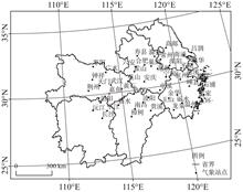
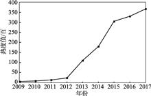
Rural tourism has important practical significance for optimizing the rural industrial structure, and recovering the rural economy, especially for the implementation of the rural revitalization strategy. Thus, rural tourism is not only the focus of local government and tourism enterprises, but also a hot topic in domestic and international tourism research. At the same time, with the development and popularization of the Internet, travel websites, social software and other online platforms have become important tools to obtain travel information, make travel decisions, and share travel experiences. Tourism big data provides data sources and methodological support for rural tourism research. Based on data of tourism network, this paper puts forward a method for identifying rural tourism hotspots. Taking Jiangsu province as an example, this paper uses the methods of trend surface, nuclear density estimation and hot spot analysis to explore the cold and hot patterns of rural tourism, and reveals the influencing factors of the evolution with the help of geographic detectors. The results show that: (1) The annual and seasonal changes of rural tourism heat are obvious. The annual change presents s an "S" shaped evolution track, seasonal variation is characterized by "three peaks and four valleys", but the degree of seasonal influence on different types of rural tourist attractions is slightly different. (2) The spatial structure of rural tourism in Jiangsu province experienced the evolution of "mononuclear-dual-nuclear-trinuclear" in 2009-2017, but its heterogeneity is still significant, basically maintaining the overall characteristics of "high in the south and east regions, while low in the north and west regions". The hot spots are concentrated in southern Jiangsu and gradually evolve into cold spots in the north. The evolution of spatial structure shows a trend of "expanding from the west to the north". (3) There are obvious strength differences and time variations among the influencing factors. Transportation convenience and reception capacity have always been the main influencing factors. The economic development has a significant positive impact on the early development of rural tourism, and the influence of tourism resource tends to decline. The positive influence of ecological environment and government orientation on rural tourism is increasing. Hotspot identification based on network data provides a new perspective for quantitative research of rural tourism. In terms of practicability, it is helpful to clarify the evolution characteristics of the cold and hot patterns of rural tourism so as to provide important guiding significance for rural tourism resource development and regional cooperation.Rural tourism has important practical significance for optimizing the rural industrial structure, and recovering the rural economy, especially for the implementation of the rural revitalization strategy. Thus, rural tourism is not only the focus of local government and tourism enterprises, but also a hot topic in domestic and international tourism research. At the same time, with the development and popularization of the Internet, travel websites, social software and other online platforms have become important tools to obtain travel information, make travel decisions, and share travel experiences. Tourism big data provides data sources and methodological support for rural tourism research. Based on data of tourism network, this paper puts forward a method for identifying rural tourism hotspots. Taking Jiangsu province as an example, this paper uses the methods of trend surface, nuclear density estimation and hot spot analysis to explore the cold and hot patterns of rural tourism, and reveals the influencing factors of the evolution with the help of geographic detectors. The results show that: (1) The annual and seasonal changes of rural tourism heat are obvious. The annual change presents s an "S" shaped evolution track, seasonal variation is characterized by "three peaks and four valleys", but the degree of seasonal influence on different types of rural tourist attractions is slightly different. (2) The spatial structure of rural tourism in Jiangsu province experienced the evolution of "mononuclear-dual-nuclear-trinuclear" in 2009-2017, but its heterogeneity is still significant, basically maintaining the overall characteristics of "high in the south and east regions, while low in the north and west regions". The hot spots are concentrated in southern Jiangsu and gradually evolve into cold spots in the north. The evolution of spatial structure shows a trend of "expanding from the west to the north". (3) There are obvious strength differences and time variations among the influencing factors. Transportation convenience and reception capacity have always been the main influencing factors. The economic development has a significant positive impact on the early development of rural tourism, and the influence of tourism resource tends to decline. The positive influence of ecological environment and government orientation on rural tourism is increasing. Hotspot identification based on network data provides a new perspective for quantitative research of rural tourism. In terms of practicability, it is helpful to clarify the evolution characteristics of the cold and hot patterns of rural tourism so as to provide important guiding significance for rural tourism resource development and regional cooperation.
- Dec. 28, 2020
- Journal of Natural Resources
- Vol. 35, Issue 12, 2848 (2020)
- DOI:10.31497/zrzyxb.20201203
Jun-long LI, Xiang-zheng DENG, Fan ZHANG, and Chuang-neng CAI
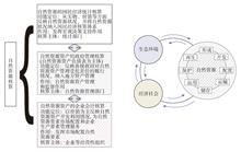
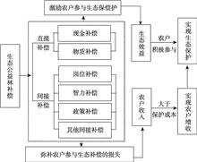
Based on the survey data of 499 farmers in Sanming, Fujian, the method of propensity score matching was used to measure the income effects of cash compensation and post compensation for farmers. The results show that both cash compensation and post compensation have positive effects on farmers' income. The effect of cash compensation on farmers' income is insignificant, while post compensation has 55.4% and 57% net effect on farmers' total income and per capita income, respectively. Further research found that the two compensation methods had different income effects for poor and non-poor farmers. Cash compensation is not conducive to poor farmers' income, while post compensation has significant positive effects across farmers with different income. In addition, considering the basic mission of ecological forest, it is found that the net effects of cash compensation and post compensation on ecological protection are different. Therefore, scientific planning on compensation methods and compensation standards is a fundamental way to achieve the double effects of ecological protection and farmers' income increase.Based on the survey data of 499 farmers in Sanming, Fujian, the method of propensity score matching was used to measure the income effects of cash compensation and post compensation for farmers. The results show that both cash compensation and post compensation have positive effects on farmers' income. The effect of cash compensation on farmers' income is insignificant, while post compensation has 55.4% and 57% net effect on farmers' total income and per capita income, respectively. Further research found that the two compensation methods had different income effects for poor and non-poor farmers. Cash compensation is not conducive to poor farmers' income, while post compensation has significant positive effects across farmers with different income. In addition, considering the basic mission of ecological forest, it is found that the net effects of cash compensation and post compensation on ecological protection are different. Therefore, scientific planning on compensation methods and compensation standards is a fundamental way to achieve the double effects of ecological protection and farmers' income increase.
- Dec. 28, 2020
- Journal of Natural Resources
- Vol. 35, Issue 12, 2942 (2020)
- DOI:10.31497/zrzyxb.20201210

Er-fu DAI, Xiao-fan WANG, Jian-jia ZHU, and Xiao-li WANG
Plantations in China are facing a series of issues, such as structure degradation and function reduction. Thus, it is urgently requested to implement effective measures on plantations through reasonable forest management strategies. The Moshao forest farm of Huitong ecological station, which is a typical forest ecosystem in Red Soil Hilly Region of South China, is the study area to examine the dynamics of forest area and aboveground biomass (AGB) in the next century. The landscape disturbance model named LANDIS-II was employed in this study to simulate the effects of harvesting intensities and artificial regeneration on artificial coniferous forest, artificial broad-leaved forest, and natural broad-leaved forest by six scenarios. The scenarios included low, middle, high harvest intensity and each scenario had an artificial regeneration option after harvesting. The results showed that as the harvesting intensity went heavier, the area of artificial coniferous forest decreased. Conversely, natural forest area increased. And the forest AGB decreased sharply when the harvesting intensity was high. Plantations could take advantages of artificial regeneration to remain the area and facilitate the AGB accumulation. The scheme of harvesting with 20% of plantations every 10 years and followed by artificial regeneration would basically retained the area and AGB at the initial level in the next century. Therefore, this scheme was more applicable to the long term development of the forest in the study area and helpful to achieve the forest sustainable management of Chinese fir and masson pine plantations.Plantations in China are facing a series of issues, such as structure degradation and function reduction. Thus, it is urgently requested to implement effective measures on plantations through reasonable forest management strategies. The Moshao forest farm of Huitong ecological station, which is a typical forest ecosystem in Red Soil Hilly Region of South China, is the study area to examine the dynamics of forest area and aboveground biomass (AGB) in the next century. The landscape disturbance model named LANDIS-II was employed in this study to simulate the effects of harvesting intensities and artificial regeneration on artificial coniferous forest, artificial broad-leaved forest, and natural broad-leaved forest by six scenarios. The scenarios included low, middle, high harvest intensity and each scenario had an artificial regeneration option after harvesting. The results showed that as the harvesting intensity went heavier, the area of artificial coniferous forest decreased. Conversely, natural forest area increased. And the forest AGB decreased sharply when the harvesting intensity was high. Plantations could take advantages of artificial regeneration to remain the area and facilitate the AGB accumulation. The scheme of harvesting with 20% of plantations every 10 years and followed by artificial regeneration would basically retained the area and AGB at the initial level in the next century. Therefore, this scheme was more applicable to the long term development of the forest in the study area and helpful to achieve the forest sustainable management of Chinese fir and masson pine plantations.
- Dec. 28, 2020
- Journal of Natural Resources
- Vol. 35, Issue 12, 2995 (2020)
- DOI:10.31497/zrzyxb.20201214
Bai-lin ZHANG, Jia-cheng QIAN, and Wei-min CAI
Mixed land use advocates that the land has multiple uses and functions, which is an important way to improve the vitality of economic development and the intensive use of land. At present, mixed land use is mainly applied in urban land use evolution and planning practice. With the intensification of urban-rural interaction, the urban-rural boundary tends to be blurred, and the internal structure and function of rural residential land in urban suburbs are gradually diversified, showing significant mixed utilization characteristics. Based on this, this paper attempts to apply mixed land use to the evolution and planning of rural residential land use. On the basis of reviewing the theory of mixed land use and its application, according to the logic of "connotation characteristics-quantitative evaluation-driving mechanism-practice approach", the systematic analysis of the mixed use of rural residential land in urban suburbs was carried out, and the optimization of rural residential areas was proposed. Finally, we take Yaocun village, which is located in the suburbs of Tianjin, as an example to demonstrate the research framework proposed in this paper. The ideas and plans for the mixed land use theoretically enrich the methods and framework for the transformation of rural residential land use, and provide scientific support for the preparation of village planning and the implementation of the strategy for rural revitalization in practice.Mixed land use advocates that the land has multiple uses and functions, which is an important way to improve the vitality of economic development and the intensive use of land. At present, mixed land use is mainly applied in urban land use evolution and planning practice. With the intensification of urban-rural interaction, the urban-rural boundary tends to be blurred, and the internal structure and function of rural residential land in urban suburbs are gradually diversified, showing significant mixed utilization characteristics. Based on this, this paper attempts to apply mixed land use to the evolution and planning of rural residential land use. On the basis of reviewing the theory of mixed land use and its application, according to the logic of "connotation characteristics-quantitative evaluation-driving mechanism-practice approach", the systematic analysis of the mixed use of rural residential land in urban suburbs was carried out, and the optimization of rural residential areas was proposed. Finally, we take Yaocun village, which is located in the suburbs of Tianjin, as an example to demonstrate the research framework proposed in this paper. The ideas and plans for the mixed land use theoretically enrich the methods and framework for the transformation of rural residential land use, and provide scientific support for the preparation of village planning and the implementation of the strategy for rural revitalization in practice.
- Dec. 28, 2020
- Journal of Natural Resources
- Vol. 35, Issue 12, 2929 (2020)
- DOI:10.31497/zrzyxb.20201209
Meng-wen WANG, Wei QI, Peng-tao WANG, and Zhuo-ran WANG
Based on field monitoring and 3S technology, Qixia city in the low hilly area of Eastern Shandong province was taken as the research area. Pearson correlation, unconstrained PCA and corresponding canonical analysis (CCA) were used to study the coupling between landscape pattern and non-point source pollution at different watershed scales. The results show that: (1) The spatial variation of landscape pattern is obvious; the patches of agricultural land and construction land are relatively fragmented at the characteristic scale; and the patches of other types of land are highly aggregated. (2) The river surface source pollutants in the study area are mainly TN-based, and the main river outlet is the more polluted area. (3) The influence of landscape pattern on water quality during the wet period is greater than that of the normal water period, and TN and EC are most sensitive to the change of land use type area ratio and landscape pattern index. At different scales, water quality affected by landscape pattern and land use type is different. (4) In normal period at riverside scale, landscape that has the greatest impact on TN is the patch density, and EC is most affected by landscape edge density. At small basin scale TN is greatly affected by landscape spread, and COD is closely related to landscape diversity. The diversity of landscape on the scale of the riverbank during the wet period has the greatest influence on TN, the EC is greatly affected by the polymerization of the plaques, and the biggest factors affecting TN on the small basin scale are consistent with the flat water period, and EC is closely related to landscape spread. (5) At small basin landscape, TN is mainly affected by the density of forest land patch, TP and cultivated land dispersion are closely related to the parallel index, the abundance of water TN is significantly influenced by the forest land dispersion and juxtaposition index, TP is sensitive to the change of the average dimensionality of forest land, and EC is most influenced by grassland aggregation. Basically, the study clarified the spatial distribution characteristics of landscape pattern and non-point source pollution in the study area, and discussed the correlation between them at different scales, which provided a scientific basis for sustainable utilization of water and land resources in Qixia city.Based on field monitoring and 3S technology, Qixia city in the low hilly area of Eastern Shandong province was taken as the research area. Pearson correlation, unconstrained PCA and corresponding canonical analysis (CCA) were used to study the coupling between landscape pattern and non-point source pollution at different watershed scales. The results show that: (1) The spatial variation of landscape pattern is obvious; the patches of agricultural land and construction land are relatively fragmented at the characteristic scale; and the patches of other types of land are highly aggregated. (2) The river surface source pollutants in the study area are mainly TN-based, and the main river outlet is the more polluted area. (3) The influence of landscape pattern on water quality during the wet period is greater than that of the normal water period, and TN and EC are most sensitive to the change of land use type area ratio and landscape pattern index. At different scales, water quality affected by landscape pattern and land use type is different. (4) In normal period at riverside scale, landscape that has the greatest impact on TN is the patch density, and EC is most affected by landscape edge density. At small basin scale TN is greatly affected by landscape spread, and COD is closely related to landscape diversity. The diversity of landscape on the scale of the riverbank during the wet period has the greatest influence on TN, the EC is greatly affected by the polymerization of the plaques, and the biggest factors affecting TN on the small basin scale are consistent with the flat water period, and EC is closely related to landscape spread. (5) At small basin landscape, TN is mainly affected by the density of forest land patch, TP and cultivated land dispersion are closely related to the parallel index, the abundance of water TN is significantly influenced by the forest land dispersion and juxtaposition index, TP is sensitive to the change of the average dimensionality of forest land, and EC is most influenced by grassland aggregation. Basically, the study clarified the spatial distribution characteristics of landscape pattern and non-point source pollution in the study area, and discussed the correlation between them at different scales, which provided a scientific basis for sustainable utilization of water and land resources in Qixia city.
- Dec. 28, 2020
- Journal of Natural Resources
- Vol. 35, Issue 12, 3007 (2020)
- DOI:10.31497/zrzyxb.20201215
Dan-dan ZHAO, Hong ZHOU, and Fu-xiong GAO
Under the background of incomplete factor market and farmers' differentiation, this paper explores the internal behavior logic between different types of farmers, technical constraints of cultivated land protection and technical choices, in order to provide reference for the sustainable development of cultivated land quality in China. In this paper, probit and logit methods are used to analyze different types of farmers' willingness to choose technology, behavior logic and differences in technology selection under different constraints. The results show that: pure farmers, class I and class II households have unity in farmland protection intention, but with the increase of non-agricultural income, farmers' farmland protection intention gradually decreases. In the aspect of behavioral logic, there are significant differences in the choice of different types of farmers' cultivated land protection technology. There are asymmetry and deviation between different types of farmers' endowment characteristics and different cultivated land protection technology, which are mainly constrained by different technical attributes and risk preferences. Therefore, in the implementation and application of farmland protection technology, more consideration should be given to different farmers' endowment advantages and risk preference.Under the background of incomplete factor market and farmers' differentiation, this paper explores the internal behavior logic between different types of farmers, technical constraints of cultivated land protection and technical choices, in order to provide reference for the sustainable development of cultivated land quality in China. In this paper, probit and logit methods are used to analyze different types of farmers' willingness to choose technology, behavior logic and differences in technology selection under different constraints. The results show that: pure farmers, class I and class II households have unity in farmland protection intention, but with the increase of non-agricultural income, farmers' farmland protection intention gradually decreases. In the aspect of behavioral logic, there are significant differences in the choice of different types of farmers' cultivated land protection technology. There are asymmetry and deviation between different types of farmers' endowment characteristics and different cultivated land protection technology, which are mainly constrained by different technical attributes and risk preferences. Therefore, in the implementation and application of farmland protection technology, more consideration should be given to different farmers' endowment advantages and risk preference.
- Dec. 28, 2020
- Journal of Natural Resources
- Vol. 35, Issue 12, 2956 (2020)
- DOI:10.31497/zrzyxb.20201211
Jian-zhi LIU, Yan-gang FANG, and Ru-ru WANG
Under the background of the agricultural supply-side structural reform and rural revitalization, it is critical to raise farmers' income, realize sustainable agricultural development and guarantee food security by developing multiple agriculture functions in various regions and coordinating the development of regions with different agricultural functional characteristics. The spatio-temporal differentiation of agricultural multifunctions results from the comprehensive effects of the agricultural resource endowments and the socio-economic development level and stages. This paper constructs an evaluation index system of agricultural multifunctions. Taking Shandong province as an example, this paper analyzes the spatio-temporal evolution characteristics and driving mechanisms of agricultural multifunctions at county level from 2004 to 2017 by using spatial mismatch, regression analysis and so on. The results are shown as follows: The spatio-temporal evolution characteristics of agricultural functions in the province were significantly different during 2004-2017. Among them, the agricultural products supplying function showed a growth trend of increasing first and decreasing afterwards, and its high-value areas were mainly distributed in the "half-ring" area surrounding the south-central mountainous area of Shandong province; the economic development function showed a growth trend of decreasing first and increasing afterwards, and its high-value areas were transformed from traditional agricultural areas with high proportion of agriculture to modern agricultural areas with high agricultural output value and distinctive agricultural areas which have high-value agricultural products or prosperous correlative industries such as agricultural tourism; the social security function showed a downward trend, and its high-value areas were concentrated in the grain producing areas with large farmland area per labor and the mountainous-hilly areas with distinctive agriculture; the ecological service function showed a downward trend of decreasing first and increasing afterwards, and its high-value areas were mainly distributed in mountainous-hilly areas with good ecological basement. The impact of factors on different elements of the same function differed in direction and extent, which resulted in changes of agricultural functional structure. Finally, based on the functional perspective, this paper proposes the development paths and zoning optimization strategies for agriculture in Shandong province.Under the background of the agricultural supply-side structural reform and rural revitalization, it is critical to raise farmers' income, realize sustainable agricultural development and guarantee food security by developing multiple agriculture functions in various regions and coordinating the development of regions with different agricultural functional characteristics. The spatio-temporal differentiation of agricultural multifunctions results from the comprehensive effects of the agricultural resource endowments and the socio-economic development level and stages. This paper constructs an evaluation index system of agricultural multifunctions. Taking Shandong province as an example, this paper analyzes the spatio-temporal evolution characteristics and driving mechanisms of agricultural multifunctions at county level from 2004 to 2017 by using spatial mismatch, regression analysis and so on. The results are shown as follows: The spatio-temporal evolution characteristics of agricultural functions in the province were significantly different during 2004-2017. Among them, the agricultural products supplying function showed a growth trend of increasing first and decreasing afterwards, and its high-value areas were mainly distributed in the "half-ring" area surrounding the south-central mountainous area of Shandong province; the economic development function showed a growth trend of decreasing first and increasing afterwards, and its high-value areas were transformed from traditional agricultural areas with high proportion of agriculture to modern agricultural areas with high agricultural output value and distinctive agricultural areas which have high-value agricultural products or prosperous correlative industries such as agricultural tourism; the social security function showed a downward trend, and its high-value areas were concentrated in the grain producing areas with large farmland area per labor and the mountainous-hilly areas with distinctive agriculture; the ecological service function showed a downward trend of decreasing first and increasing afterwards, and its high-value areas were mainly distributed in mountainous-hilly areas with good ecological basement. The impact of factors on different elements of the same function differed in direction and extent, which resulted in changes of agricultural functional structure. Finally, based on the functional perspective, this paper proposes the development paths and zoning optimization strategies for agriculture in Shandong province.
- Dec. 28, 2020
- Journal of Natural Resources
- Vol. 35, Issue 12, 2901 (2020)
- DOI:10.31497/zrzyxb.20201207
- <
- 1
- 2
- 3
- ...
- 161
- >


© Copyright 2018-2021 | Chinese Laser Press. All Rights Reserved 沪ICP备15018463号-20