1Northwest Land and Resource Research Center, Shaanxi Normal University, Xi'an 710119, China
2Key Laboratory of Regional Sustainable Development Modeling, Institute of Geographic Sciences and Natural Resources Research, CAS, Beijing 100101, China
3College of Resources and Environment, University of Chinese Academy of Sciences, Beijing 100049, China
Tao LI, Jiaoe WANG, Jie HUANG, Xingchuan GAO. Exploring temporal heterogeneity in an intercity travel network: A comparative study between weekdays and holidays in China[J]. Journal of Geographical Sciences, 2020, 30(12): 1943
Copy Citation Text
A largely unexplored application of “Big Data” in urban contexts is using human mobility data to study temporal heterogeneity in intercity travel networks. Hence, this paper explores China’s intercity travel patterns and their dynamics, with a comparison between weekdays and holidays, to contribute to our understanding of these phenomena. Using passenger travel data inferred from Tencent Location Big Data during weekdays (April 11-15, 2016) and National Golden Week (October 1-7, 2016), we compare the spatial patterns of Chinese intercity travel on weekdays and during Golden Week. The results show that the average daily intercity travel during Golden Week is significantly higher than that during weekdays, but the travel distance and degree of network clustering are significantly lower. This indicates temporal heterogeneity in mapping the intercity travel network. On weekdays, the three major cities of Beijing, Shanghai, and Guangzhou take prominent core positions, while cities that are tourism destinations or transportation hubs are more attractive during Golden Week. The reasons behind these findings can be explained by geographical proximity, administrative division (proximity of cultural and policy systems), travel distance, and travel purposes.
Human mobility has been a key concept in geography, transport, and regional planning. Measuring and analyzing the flows of travelers at different scales (spatial and temporal) is a major topic in the mobility literature (Jin et al., 2018). Increasing mobility and intercity travel can be expected to lead to economic and social benefits, but also to negative environmental consequences (Limtanakool et al., 2006; Dargay and Clark, 2012). While intercity travel may strengthen the connections between different regions and provide better access to public services and social connections, it can also involve increased energy consumption and the emission of pollutants, leading to negative environmental impacts (Limtanakool et al., 2005; Arbués et al., 2016). Aultman-Hall and Ullman (2020) stated that “truly understanding mobility in our global society requires inclusion of long-distance intercity travel”. Therefore, understanding patterns of intercity travel is of importance for the development of transport infrastructure and making mobility sustainable.
The time-space compression brought by the development of high-speed transport networks and ICT as well as the continuous regional integration largely promotes the expansion of human activity space in China (Kuhnimhof et al., 2009; Jia et al., 2018). On the other hand, with the improvement of residents’ income level and the change of consumption structure, long-distance travel demand is also gradually increasing. As a result, human mobility has experienced a significant increase in terms of vehicle-kilometers travelled in China. In such a case, the number of people travelling between cities is increasing. In this study, this type of travel is referred to as intercity travel.
With the increasing focus on questions of regional integration and long-distance mobility, there is a growing body of literature on medium- and long-distance travel and intercity travel (Limtanakool et al., 2005; Wang and Jin, 2007; Arbués et al., 2016; Wang et al., 2020). Differences in travel periods and travel time availability have a strong effect on intercity travel and can lead to heterogeneity in intercity travel patterns. The patterns of travel on weekdays and holidays have completely different attributes, and the reasons for people traveling on different days are quite different. Therefore, it is helpful to compare intercity travel in these two periods to fully understand the patterns involved. However, most previous studies have focused on the spatial dimension of intercity travel and have paid little attention to the temporal dimension, specifically temporal heterogeneity in intercity travel. Exceptions are the studies by Neal (2014) and Jin et al. (2018). Neal (2014) used air-traffic data to differentiate air-traffic networks in summer and winter. Although this distinction between the seasons revealed different structural varieties in air traffic and the spatial organization of cities, the study only examined the intercity air-traffic network at the season level, thus largely ignoring other temporal scales such as the differences between weekdays and holidays. More recently, Jin et al. (2018) used user-generated content data to analyze tourist-flow networks for different lengths of trip on the intracity scale. However, they did not explore travel flows by general population at the intercity scale.
This paper aims to explore temporal heterogeneity by comparing the differences in intercity travel patterns between weekdays and National Golden Week. To this end, we applied network analysis methods and used migration data obtained from the website of Tencent Location Big Data to conduct this study. The results have important implications for transport infrastructure planning and regional studies.
The remainder of this paper is organized as follows. Section 2 reviews the literature on intercity travel. Section 3 briefly describes the data and methodology for modeling intercity travel. Subsequently, we present and discuss the empirical results in Sections 4 and 5. Finally, we present an overview of our key findings in Section 6.
2 Literature review
2.1 Long-distance and intercity travel
The terms “long-distance travel” and “intercity travel” are usually used interchangeably and long-distance is generally defined on the basis of a physical distance threshold (Arbués et al., 2016). According to the literature, long-distance trips are traditionally defined as being longer than a threshold between 50 km and 100 km (Kuhnimhof et al., 2009; Dargay and Clark, 2012). To avoid arbitrariness in the selection of this threshold, we use intercity travel, which refers to trips between cities, as our analytic object in this study.
At present, the existing literature on intercity travel can be divided into two categories. Firstly, there are those that mainly focus on the question of intercity travel per se. For example, Limtanakool et al. (2006) used DATELINE, a European long-distance mobility database, to examine the patterns of interaction between functional urban areas in France and Germany. De Montis et al. (2010) analyzed inter-municipal commuting systems in the Italian islands, including Sardinia and Sicily. A better understanding of the determinants of intercity travel can improve the performance of intercity transport systems and inform sustainable planning. As a result, secondly, a growing number of studies are examining the determinants of the choice of intercity travel mode. Socio-demographic factors (Limtanakool et al., 2006; Kuhnimhof et al., 2012; Yang et al., 2018), spatial configuration factors (Limtanakool et al., 2005; Garmendia et al., 2011; De Witte et al., 2013; Anne and Laurent, 2015), and trip characteristics (Buehler, 2011; Moeckel et al., 2015; Ye et al., 2018) all have important impacts on mode selection in intercity travel. However, compared to the rich literature on short-distance or inner-city travel studies, there have been relatively few studies on intercity travel.
As one of the key aspects of “the space of flows”, intercity travel is particularly important in studies of urban networks. The main aim of these studies is to uncover patterns of urban networks through the lens of intercity travel. Using air-passenger-flow data, Neal (2014) differentiated air-traffic networks using the dimensions of scale, species, and season. Derudder et al. (2014) evaluated the intercity connectivity of South Asian cities based on their infrastructure networks. In China, a great deal of the existing literature has analyzed the functional relationships within urban systems based on time-schedule and passenger-flow data from airlines, high-speed railways (HSR), conventional railways, and coaches. For instance, Luo (2010) and Feng et al. (2014) evaluated the polycentricity of the Yangzi River Delta and the Pearl River Delta, respectively, based on HSR schedule data. Intercity travel with different modes of transportation (air, train, and coach) can reveal urban networks on different spatial scales and across regions. Some studies have also compared the urban relationships reflected by different intercity travel modes (Chen et al., 2015; Wang and Jing, 2017). For example, using 2013 origin/destination passenger-flow data, Yang et al. (2018) compared the spatial configurations of Chinese national urban systems in terms of both HSR and airline networks. Wang et al. (2020) used timetable data for HSR and coaches to compare the spatial patterns of intercity connections in these two modes.
Previous studies of intercity travel have rarely addressed its temporal heterogeneity. Differences in the travel period and travel time availability have a strong effect on intercity travel patterns. “Big Data” sources offer new opportunities for analysis of the temporal heterogeneity of intercity travel patterns.
2.2 Big data in intercity travel studies
In this era of Big Data, geo-referenced data has increasingly attracted interest from scholars and has been widely used in geographical research (Liu et al., 2014; Yuan et al., 2020; Zhang et al., 2020). With respect to various data sources from location-based services on human mobility, Tencent and Baidu have been found to be more accurate than other sources (Li et al., 2016). Recent studies on intercity travel have started to introduce this kind of data in their analyses. Using migration data from Tencent Location and Baidu Location Big Data, many studies have explored the spatial patterns of population flow networks during the Chinese Spring Festival (Liu and Shi, 2016; Wei et al., 2016). Xu et al. (2017) used Tencent Location Big Data to analyze unbalanced population migration between cities and uncover spatial differences in urban development during Chinese Spring Festival. Later, Pan and Lai (2019) used the same data as Xu et al. (2017) to explore the spatial patterns of daily flow mobility during the National Day and Mid-Autumn Festival in China. Additionally, social-network data containing location information, such as check-in data from Twitter, Foursquare, and Sina, is also valuable for examining patterns in human mobility. Liu et al. (2014) analyzed spatial patterns in intercity trips and distance decay in China based on social-media check-in data. Zhang et al. (2020) used location-based social media to map the spatial patterns of intercity travel in the Yangtze River Delta of China. Compared with traditional data (questionnaires, sampling, and census data), geo-referenced big data can provide real time information about the dynamic movements of people, allowing exploration of temporal heterogeneity in intercity travel patterns.
To the best of our knowledge, relatively few studies have compared intercity travel during different periods in one area using the same type of passenger-flow data. Our research tries to fill this gap by using human mobility data released by Tencent for weekdays and holidays within the national urban system of China.
3 Data and methodology
3.1 Data sources
Passenger intercity travel data from weekdays (April 11-15, 2016) and during National Golden Week (October 1-7, 2016) from the Tencent Location Big Data platform were employed in this study. The data encompasses 362 cities, including 293 prefecture-level cities, four municipalities, and 65 county-level cities in mainland China. Passenger intercity travel data from Tencent Location Big Data provides the top-ten inflow and outflow records for each city. Additional passenger inflow (outflow) records can be appropriately supplemented by the outflow (inflow) records of other cities to establish intercity travel patterns. This data has been applied to reveal the characteristics of China’s urban development during the Spring Festival period (Xu et al., 2017).
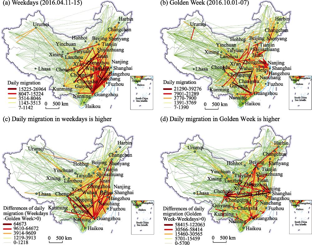
It should be noted that the Tencent platform provides a relative passenger intercity travel volume, not an absolute volume value. In fact, the relative index of the passenger travel data is better than the attributes reflected by the absolute volume when using Big Data to study the characteristics of residents’ travel (Yuan et al., 2020). Tencent’s passenger intercity travel-flow data is based on daily statistics, which can cover most of the users’ long-distance and short-distance travel behaviors. To a certain extent, it avoids underestimation of long- distance travel data and false increases in short-distance travel data. On this basis, a directed, weighted intercity population travel matrix with cities as nodes and population flow as edges was constructed. The scale of the average daily travel volume of Chinese residents during Golden Week is basically more than twice that of weekdays (Table 1) and is mainly characterized by relative short-distance travel from a core city to its surrounding cities, while weekdays are mainly characterized by long-distance travel (Figure 1).
Periods
Number of nodes
Number of edges
Total linked value
Average
Maximum
Minimum
CV
Weekdays
362
8430
34 817 749
4130
191 590
7
2.22
Golden Week
362
8588
72 681 843
8463
263 724
7
1.94
Table 1.
Descriptive statistics of intercity travel networks for weekdays and Golden Week
To reveal the centrality of cities in the network, this paper selects two indexes: the weighted degree centrality index (WDC) and the city weighted dominance index (DIT). These two indexes are calculated as follows (Jiao et al., 2016; Yang et al., 2018):
where Ti is the sum of passenger inflow and outflow of city i (i≠j), Di is the degree value of city i, which is equal to the sum of the outdegree and indegree of that city, and α is the coefficient parameter, which in this paper is 0.5 following Jiao et al. (2016). The parameter WDCi indicates the absolute strength of city i in the network; the larger its value, the higher the absolute strength of the city in the entire network. The parameter DITi indicates the relative strength of city i, and this can be used to illustrate the relative dominance of each city in the entire intercity travel network; the higher the value of this parameter, the stronger the relative dominance of city i, and when its value is greater than 1, the city’s dominance is greater than the average of the other cities in the network.
To reveal hierarchical structure in the network as a whole, the city equilibrium degree coefficient ODIc indicating the extent to which the total interaction in distributed evenly across all cities in the network. The value of ODIc is calculated as follows (Yang et al., 2018):
where Zi represents the proportion of the sum of the edge strengths associated with city i as compared to the sum of the edge strengths associated with all cities in the network, I is the number of cities in the network, and 0≤ODIc≤1. When ODIc=0, this indicates the greatest hierarchical differential, and this index can be used to illustrate the differences between cities in the entire intercity travel network.
3.2.2 Link connectivity
The intercity travel link connectivity refers to the connectivity of a city pair, indicating the relative strength of a link (RSL) in the network, and this can be calculated according to Yang et al. (2018)
where tij is the total number of passengers travelling between city i and city j (i ≠ j). The parameter RSLij represents the relative strength of a link, which indicates the proportion of a certain city’s connection strength as a fraction of the total connection strength of the whole travel network, and 0≤RSLij≤1. The closer this value is to 1, the higher the correlation ratio between city i and city j and the greater the dominance of the link. Since some of the values of this parameter will be rather small, to clearly understand their strength values, the RSLij value is multiplied by 1000.
3.2.3 Community structure mining and visualization model
Considering that this study constructs a directed weighted network and the network data represents the actual intercity relationship flows, this paper adopts the Infomap algorithm, as proposed by Rosvall and Bergstrom (2008) to identify the community structure. This method comprehensively considers topological attributes such as node weight, connection edge weight, and connection direction during the process of community mining and has been well applied in mining network community structures with actual flow interactions. To intuitively examine the characteristics of changes in intercity travel network groups between the two periods, this paper uses the alluvial diagram proposed by Rosvall and Bergstrom (2008) to carry out visual comparisons of network groups, and the group mining and the drawing of the alluvial diagram are completed by means of the Map Equation software package (http://www.mapequation.org/).
3.2.4 City role recognition model
Exploring the role of each city is of particular importance in a large network. In this paper, the within-module degree and participation coefficient proposed by Guimerà and Amaral (2005) are adopted to identify the role of each city in the intercity travel network based on the characteristic that cities with the same role should have similar topological properties. The basic principle of this method is that the role of a city can be determined through a comparison between its own module and other modules. The specific steps are as follows. (1) Calculate the within-module degree (zi) of the city within its affiliated module; the larger the value of zi, the higher the weighted degree centrality of the city within the module, and vice versa. (2) Calculate the external connectivity between the city and each group (including the affiliated group) city, which can be called the participation coefficient (Pi) and represents the distribution equilibrium level of the connectivity associated with city i, and 0≤Pi≤1; the closer Pi is to 1, the more that connections directly related to city i tend to be evenly distributed in each group, and vice versa. (3) Visualize Pi and zi as the abscissa and ordinate of a graph, respectively, determine a critical value based on the actual distribution of data, and then classify the city roles (Figure 2). The formulae for calculating the within-module degree (zi) and participation coefficient (Pi) are given below:
where Ki is the weighted degree of centrality of city i in its group Si, $\overline{{{K}_{{{S}_{i}}}}}$ is the average of Ki over all cities in Si, ${{\sigma }_{{{K}_{{{S}_{i}}}}}}$ is the standard deviation of Ki in Si, KiS is the weighted degree of centrality of city i associated with each group S, ki is the weighted degree of centrality of city i in the whole network, and NM is the number of groups.
Figure 2.
Diagram of city roles based on the method of the intra-inter group importance parameter
4 Hierarchical structure and spatial patterns of intercity travel network
4.1 City nodes
4.1.1 Hierarchical size structure
In general, the travel size in Golden Week was higher than those on weekdays. The average degree values on weekdays and during Golden Week were 44.8 and 45.7, respectively. Without considering their weight, the average number of directly related cities associated with each city was nearly equal. The average values of the weighted degree in the two periods were 185 200 and 386 605, respectively. Meanwhile, the average value of DITi also increased from 3.91 on weekdays to 5.09 during Golden Week. That is to say, the travel size during Golden Week was significantly higher than that on weekdays.
Figure 3 presents the rank-size distribution fitting analyses based on each city’s WDCi value for the three regions and the whole of China for the two periods. The fitting parameters are also summarized in Table 2 below. The distributions of cities’ WDCi values in the two periods generally presented a typical Pareto distribution pattern, with a Zipf value above 1. Specifically, the ODIc values on weekdays and during Golden Week were 0.84 and 0.88, respectively. Although the overall distribution was relatively balanced, the rank-size distributions of WDCi values in Golden Week tended to be flatter. The value of goodness of fit on weekdays and during Golden Week were 0.64 and 0.82, respectively, indicating that the hierarchical organization of China’s intercity travel network based on passenger intercity travel data conformed to a rank-size distribution. During Golden Week, with the general increase in the frequency and scale of travel, the differences among the three regions were significantly reduced. This may be caused by the massive increase in leisure, and family-visiting flows during Golden Week. According to statistics from the China National Tourism Administration, 593 million tourists were received during the National Day Golden Week in 2016. Increased numbers of intercity trips generated by the increase in leisure time and income were reflected in the three major regions as well as the whole country. The goodness of fit within the three regions was above 0.7, which is also consistent with the rank-size distribution.
Figure 3.
Rank-size distribution of <italic>WDC<sub>i</sub></italic> of intercity travel network for weekdays and Golden Week
Figure 4 maps the DITi values for the two periods and the absolute changes between the two periods to identify the geography of city centrality. Table 3 lists the top-20 dominant cities with high DITi values for the two periods and the top-20 absolute changes in DITi value.
Figure 4.
Spatial distribution of DIT<italic><sub>i</sub></italic> and its absolute changes for weekdays and Golden Week
The “space-time compression” effect brought about by high-speed transport development plays an important role in expanding travel distances and activity spaces. The regions with high DITi values were mainly concentrated along HSR corridors in urban agglomerations, including the Beijing-Shanghai line in the Yangtze River Delta, Beijing-Tianjin-Hebei, the Guangzhou-Shenzhen line in the Pearl River Delta, and the Qingdao-Jinan line in the Shandong Peninsula area. Specifically, the top-six cities in the two periods were the same: Beijing, Shanghai, Shenzhen, Guangzhou, Chongqing, and Chengdu. The remaining 14 cities mainly included sub-core cities of Beijing-Tianjin-Hebei, the Yangtze River Delta, the Pearl River Delta, the Chengdu-Chongqing, and core cities of other urban agglomerations such as Tianjin, Nanjing, Hangzhou, Suzhou, Wuhan, Xi’an, and Changsha.
With regard to the ranking changes of the cities between the two periods, apart from Beijing, Shanghai, Shenzhen, Guangzhou, Zhengzhou, and Wuhan, there were obvious ranking changes for the other cities between weekdays and Golden Week, as shown in Table 3. Among them, the rankings of Chongqing and Chengdu were swapped, and Hangzhou, Xi’an, Suzhou, Tianjin, and Kunming significantly improved their rankings. For instance, Xi’an ranked 12th on weekdays, but rose to 8th in Golden Week, with tourism in Xi’an playing a major role. The rankings of Dongguan, Foshan, and Nanning dropped significantly. The DITi values for Guangzhou, Shenzhen, and Shanghai were significantly reduced, to 5.63, 5.44, and 3.05, respectively. The DITi value of 41 cities increased significantly, with an average value of absolute change of 3.96. The cities with greater improvement were concentrated in the peripheral areas of Beijing-Tianjin-Hebei, the Yangtze River Delta, the Pearl River Delta, and the Chengdu-Chongqing, as well as the core cities in Shandong Peninsula, the central and southern parts of Liaoning Province, and the Harbin-Changchun urban agglomeration. Wuhan, Chengdu, Xi’an, and other transportation hub and tourist cities had the greatest improvements, with changes of 10.17, 10.06, and 8.57, respectively.
4.1.3 City role identification
We calculated the within-module degree (zi) and participation coefficient (Pi) associated with each city in the intercity travel network. The role of each city was then identified according to the definitions above, and these are plotted in Figure 5. The numbers of hub and non-hub cities in the two periods were 34, 33, 328, and 329, accounting for 9.39%, 9.12%, 90.61%, and 90.88%, respectively. Provincial capitals and main central cities were classified as hub cities. On weekdays, the Pi values of 12 cities, including Beijing, Chengdu, Shanghai, Guangzhou, Shenzhen, Chongqing, Kunming, and Xi’an were greater than 0.75, which indicates that links with these cities were relatively evenly distributed in each module. That is to say, these cities were not only the hub cities that belong to their respective module but were also national hub cities connecting with cities of other modules. The remaining 22 provincial capitals and regional central cities were classified as regional hubs. The central cities and provincial capital cities assume the functions of political, economic, and cultural centers in their respective modules, so they had high-intensity connectivity with the non-hub cities in the module. During Golden Week, the Pi values of Beijing, Shanghai, Shenzhen, Chongqing, and Sanya were still greater than 0.75. The roles of Urumqi, Nanning, Taiyuan, Jinan, Qingdao, Dalian, and Hefei changed from regional hub to local hub. This result suggests that intercity travel in Golden Week was more dispersed than on weekdays. With regard to non-hub cities, the number of ultra-peripheral cities increased from 103 on weekdays to 182 in Golden Week, and their proportion increased from 28.45% to 50.56% accordingly.
Figure 5.
Division of city roles on weekdays and during Golden Week
4.2.1 Comparison of spatial patterns by primary linkage
Figure 6 plots dominant flows using the primary-link strength and the number of primary linking cities to identify the geography of the dominant flows. The number of primary linking cities on weekdays was higher than that during Golden Week, but the degree of hub status as central cities during Golden Week was more prominent. The number of primary linking cities decreased from 71 on weekdays to 57 during Golden Week, and the average numbers of cities linked to a primary linking city were five and six, respectively. Meanwhile, the numbers of primary linking cities with more than 10 linked cities were 14 and 17, respectively. These cities mainly included Beijing, Guangzhou, Chengdu, Shanghai, Wuhan, Zhengzhou, and Shenyang. During Golden Week, four new cities were added, including Harbin, Lanzhou, Kunming, and Chongqing. The primary-link strength index indicates the degree of dependence of each city on its primary linking city (Jin, 2001). The average primary-link strength values on weekdays and during Golden Week were 0.18 and 0.12, respectively. That is to say, the degree of agglomeration of the intercity travel network during Golden Week was lower than that on weekdays. This may be due to the intercity travel characteristics of holidays in Golden Week reducing the degree of agglomeration of the city network. Specifically, tourism cities and transportation hub cities including Dali, Chengdu, Hangzhou, Kunming, Lhasa, Xi’an, Zhengzhou, and Wuhan increased their primary-link strength value. In contrast, the central cities such as Guangzhou, Shanghai, and Beijing significantly decreased their primary-link strength value.
Figure 6.
Spatial distribution of the dominant flows of the intercity travel network on weekdays and during Golden Week
4.2.2 Comparison of spatial patterns by link centrality
Figure 7 shows the four ranks of intercity travel links for the two periods. Long-distance intercity travel constituted the main body of the weekday travel connections, and the spatial coverage was higher than that during Golden Week. During the weekdays, there was a total of 11 first-ranked links. The core cities included Beijing, Shanghai, Guangzhou, Shenzhen, Chongqing, and Foshan and Dongguan within the Pearl River Delta urban agglomeration. There was only one first-ranked link connecting Shenzhen and Dongguan in the Pearl River Delta, as identified in the first rank of the intercity network of Golden Week. The intercity links within the Pearl River Delta appeared in the first rank of the two periods, reflecting the fact that the degree of polycentricity of the Pearl River Delta was significantly higher than that of the other urban agglomerations. Intercity links involving long-distance inter-regional connections formed the main body of the second-ranked links in the two periods. There were 20 cities involved in the weekdays in addition to cities existing in the first-ranked links, including core cities such as Wuhan, Changsha, Nanjing, Hangzhou, Xi’an, Suzhou, and Changchun, as well as neighboring cities (Langfang, Baoding, Huizhou, Xianyang, and Guang’an). In Golden Week, the second-ranked links involved 17 cities. Some secondary cities such as Huanggang and Weinan appeared on this list, which may be caused by the increase in the scale of tourism travel and family visits during Golden Week. As for the third- and fourth-ranked links, the involved area further expanded to the western and northeastern parts of China. There were 118 third-ranked links and 667 fourth-ranked links on weekdays, accounting for 1.40% and 7.90% of the total number of links, respectively. There were 130 third-ranked links and 720 fourth-ranked links during Golden Week, accounting for 1.51% and 8.38% of the total number of links, respectively.
Figure 7.
Comparison of spatial patterns of the intercity travel network for weekdays and Golden Week
To further analyze the different rankings of the links for the two periods, we compared the differences in link centrality values (RSLij) for the two periods by identifying the advantaged links (RSLij(weekdays) - RSLij(Golden Week) > 0) on weekdays and the advantaged links (RSLij(Golden Week) - RSLij(weekdays) > 0) during Golden Week (Figure 8). The proximity effect of the intercity travel network was obvious during Golden Week, and the core cities in each region were mainly linked with their surrounding secondary cities. There were 2234 advantaged links on weekdays, forming a rhombic-shaped structure with Beijing, Shanghai, Guangzhou, Shenzhen, Chengdu, and Chongqing as the core cities. There was a total of 3219 advantaged links during Golden Week, showing a significant spatial proximity effect, and core cities in each region were mainly linked with neighboring secondary cities. Influenced by the differences in travel destination, scale, and frequency between the two periods, and in contrast to the characteristics of cross-regional links on weekdays, the proximity effect of the intercity travel network during Golden Week was obvious, forming a core-periphery mode, with provincial capital cities and their surrounding cities in the province as the main links.
Figure 8.
City links with an advantageous connectivity index (<italic>RSL</italic>) in the intercity travel network for weekdays and Golden Week
Based on the Infomap algorithm analysis, we visualized the communities of the intercity travel network for the two periods, and a total of 22 communities were obtained. For each period, the communities were reordered to reflect the hierarchical tendencies in the results. Communities were labeled by simply referring to what seemed to be their overriding regional geography. Figure 9 shows an alluvial diagram summarizing the changes in the intercity travel network between the two periods. According to the characteristics of geographical agglomeration, the communities of the two periods can by divided into cross-regional communities, neighboring communities composed of adjacent provinces, and single provincial communities.
Figure 9.
Divisions and changes of community structure for weekdays and Golden WeekNotes: (1) Different bars represent different communities and are arranged according to the PageRank value of the community city. The higher the PageRank value, the lower the position and the higher the importance and status of the community in the network. (2) The horizontal streamlines connecting different communities in the two periods indicate the changes of cities in each community between weekdays and Golden Week, and their width is directly proportional to the number of cities in each community. (3) To clearly show the changes in the communities between the two periods, the left panel highlights the changes between weekdays and Golden Week of the Beijing-Shanghai community and the Guangzhou-Shenzhen community, while the right panel highlights the changes in the other communities.
The formation of cross-regional communities is affected by the geographical proximity effect and space-jump effect to overcome distance friction. Specifically, the formation of cross-regional communities was driven by radiation from central cities such as Beijing, Shanghai, Guangzhou, and Shenzhen.
On weekdays, a cross-regional community centered on Beijing and Shanghai was formed, including 62 cities, which can be further divided into five secondary communities: Heilongjiang-Jilin, Beijing-Tianjin-Hebei, Shanghai-Zhejiang, Chongqing, and Hubei. The cross-regional community with Guangzhou and Shenzhen as its core cities included 40 cities, which were divided into two secondary communities of Guangdong and Henan. The Beijing-Shanghai community and the Guangzhou-Shenzhen community are located in the Beijing-Guangzhou, Beijing-Shanghai, Beijing-Harbin, and Shanghai-Chengdu riverside axial regions and were highly coupled with the national development axes, including the coastal area, Beijing-Harbin, Beijing-Guangzhou, and the Yangtze riverside corridor.
During Golden Week, the Beijing-Shanghai community still existed, but the number of cities included in it was reduced from 62 to 27, including three secondary communities, Beijing-Tianjin-Hebei, Shanghai-Zhejiang, and Chongqing. A cross-regional community including 28 cities with Harbin, Changchun, and Shenyang as its core cities was formed in northeastern China. The Guangzhou-Shenzhen cross-regional community has dissolved into the two provincial communities of Guangdong and Henan.
The neighboring communities were composed of cities from neighboring provinces that are geographically adjacent and within the hinterland of the core city. During weekdays, a community with Chengdu as its core city was formed, covering Sichuan and Tibet, including 28 cities. A community with Urumqi as its core city was formed, covering Xinjiang and the western region of the adjacent Gansu province, including 29 cities. A community with Nanjing and Suzhou as its core cities was formed, covering Jiangsu and the eastern part of the adjacent Anhui province, including 17 cities. A community with Xi’an as its core city was formed, covering Shaanxi and Qingyang of Gansu, including 11 cities. During Golden Week, a community with Lanzhou and Xining as its core cities was formed, covering Gansu, Qinghai, and Naqu in Tibet, including 22 cities. A community with Yinchuan as its core city was formed, covering Ningxia and Alashan of Inner Mongolia, including six cities. Compared with weekdays, the scope of the community with Nanjing and Suzhou as its core cities further expanded in Golden Week to cover Jiangsu and Anhui provinces, including 29 cities, and the community with Xi’an as its core city still existed, covering Shaanxi and Qingyang in the adjacent Gansu province.
In addition, the number of communities jointly formed by cities located close to each other and within the same provincial administrative region was the largest, specifically 16 and 17 for weekdays and Golden Week, respectively. The provincial communities remained stable during the two periods, including the Shandong group with Jinan and Qingdao as its core, and the Hainan community with Haikou and Sanya as its core cities.
5.2 Discussion
The formation of each community and its change between the two periods is influenced by a variety of factors, including geographical proximity, administrative divisions (cultural-policy proximity), travel distance, and travel purposes.
Geographical proximity determines the possibility of intercity interaction within a region. The closer the location, the greater the degree of intercity interaction as well as the possibility of being in the same community. For example, among the 22 communities of the two periods, provincial communities were the largest grouping, accounting for 72.73% and 77.27% of the total for the two periods, respectively. It is difficult for cities located in the border areas of provinces to be driven by the radiation of the central cities because they are geographically far from the central cities of their associated provinces. These cities attract people from the economic centers of adjacent provinces in their geographic locations and have strong interactions, thus forming neighboring communities. Administrative divisions (cultural-policy proximity) are also the main factors for the formation of provincial communities. Cultural customs, management policies, resource allocation, factor mobility, and other aspects within the same administrative region are inherently convenient, making the links between cities in one province much greater than those between provinces, while provincial capitals and major central cities in a province assume the status of hubs for inter-provincial links.
Travel distance directly affects the spatial coverage of intercity interactions. The further the travel distance is, the greater the possibility of interaction between distant cities and thus the greater the possibility of forming a cross-regional community. The average daily travel distance during Golden Week was significantly lower than that during weekdays (Figure 10). The average travel distance on weekdays and Golden week are 1325 km and 552 km, respectively. Intercity links that only occurred on weekdays were mainly inter-regional links, with an average travel distance of 1324 km, while intercity links that only occurred during Golden Week were mainly short-distance intercity links with an average travel distance of 629 km. During the weekdays, the long travel distance formed a cross-regional community with Beijing-Shanghai as its core and a cross-regional community with Guangzhou-Shenzhen as its core. The decrease in travel distance also led to the formation of a cross-regional community with Harbin, Changchun, and Shenyang as its core cities, which is consistent with the findings of Xu et al. (2017).
Figure 10.
Comparison of intercity travel distance between weekdays and Golden Week
There are significant differences in the purpose of travel on weekdays and holidays. Most of the intercity trips that take place on weekdays are mainly business trips and commuting trips between major central cities, and between cities in the upper and lower reaches of the industrial chain. Therefore, with the background of the space-time compression brought about by the development of high-speed transport, business travel on weekdays presented a cross pattern between distant national central cities (along the Beijing-Guangzhou- Shenzhen, Beijing-Shanghai, and Shanghai-Chengdu-Chongqing routes) and a network pattern between the inner and outer central cities within urban agglomerations (Shenzhen- Dongguan, Guangzhou-Foshan, and Guangzhou-Shenzhen of the Pearl River Delta city group). Most of the intercity trips that take place during holidays (such as Golden Week) are leisure and family visits. As noted earlier, 593 million tourists were received nationwide during the National Day Golden Week in 2016. Nearly half of the people in China chose to travel, which directly resulted in the daily average intercity travel scale during Golden Week being significantly higher than that on weekdays. At the same time, Sanya, Dali, Shanghai, Hangzhou, Xi’an, Xiamen, Beijing, Chengdu, Nanjing, and Guangzhou became the top-10 tourist-destination cities. Leisure and family visits mainly took place between a central city and peripheral secondary cities within its hinterland, showing a radial structure dominated by short distances (Figures 1, 6 and 9).
6 Conclusion
This paper provides a systematic analysis on the temporal heterogeneity in mapping intercity travel network. Using the migration data obtained from the website of Tencent Location Big Data in China for weekdays (April 11-15, 2016) and National Golden Week (October 1-7, 2016), this paper explored spatial patterns in China’s intercity travel network and disclose the differentiated patterns among weekdays and hoilday. Main findings of this paper include:
The total relative volume of the daily average flow during Golden Week was notably higher than that during the weekdays, but the travel distance was clearly lower. On weekdays, the intercity network formed a rhombic dominant-link structure with Beijing, Shanghai, Guangzhou, Shenzhen, Chengdu, and Chongqing as core cities. During Golden Week, the intercity travel network showed a significant proximity effect.
Patterns of network agglomeration during the two periods are of hierarchies and regional tendencies. Under the combined effects of the geographical proximity effect, administrative division (cultural-policy proximity), travel distance, travel purposes, and other factors, three types of communities formed: cross-regional communities, neighboring communities, and provincial communities. With the increasing travel volume and the popularity of shorter-distance travel during Golden Week, the influence of national hub cities significantly declined, while regional and local hubs taking dominant positions.
The level of economic development of a city is directly related to the scale of its centrality, which spatially decreased from east to west. The space-time compression effect brought about by the development of high-speed transport plays an important role in expanding travel distances and activity space.
Due to the daily trips of a large number of users who are not connected to the Tencent platform cannot be recorded, and most of trips are disassembled so that users can not identify the real OD travel, the results of this paper inevitably have some limitations. Moreover, the characteristics of intercity travel network of weekdays and holidays is not the same as the characteristics of intercity travel network dominated by business flows and tourism flows. Seeking the data acquired from questionnaire, ticketing information and other survey data would be valuable for future exploration of the formative mechanism of intercity travel network.
[2] ArbuésP, Ba?os JF, MayorM et al. Determinants of ground transport modal choice in long-distance trips in Spain. Transportation Research Part A: Policy and Practice, 84, 131-143(2016).
[3] Aultman-HallL, UllmanH. Long-distance and intercity travel: Who participates in global mobility?. In: Konstadinos G, Goulias, Adam W Davis (ed.). Mapping the Travel Behavior Genome.
Elsevier, 187-207(2020).
[4] BuehlerR. Determinants of transport mode choice: A comparison of Germany and the USA. Journal of Transport Geography, 19, 644-657(2011).
[5] ChenW, XiuC, KeW. Hierarchical structures of China's city network from the perspective of multiple traffic flows. Geographical Research, 34, 2073-2083(2015).
[6] Dargay JM, ClarkS. The determinants of long distance travel in Great Britain. Transportation Research Part A: Policy and Practice, 46, 576-587(2012).
[7] De MontisA, ChessaA, CampagnaM. Modeling commuting systems through a complex network analysis: A study of the Italian islands of Sardinia and Sicily. Journal of Transport and Land Use, 2, 39-55(2010).
[8] De WitteA, HollevoetJ, DobruszkesF. Linking modal choice to motility: A comprehensive review. Transportation Research Part A: Policy and Practice, 49, 329-341(2013).
[9] DerudderB, LiuX, KunakaC. The connectivity of South Asian cities in infrastructure networks. Journal of Maps, 10, 47-52(2014).
[10] FengC, XieD, MaX. Functional polycentricity of the urban region in the Zhujiang River Delta based on intercity rail traffic flow. Scientia Geographica Sinica, 34, 648-655(2014).
[11] GarmendiaM, Ure?a J.M, Coronado JM. Long-distance trips in a sparsely populated region: The impact of high-speed infrastructures. Journal of Transport Geography, 19, 537-551(2011).
[12] GuimeràR, Amaral L AN. Cartography of complex networks: Modules and universal roles. Journal of Statistical Mechanics: Theory and Experiment, P02001(2005).
[13] JiaT, FengZ, XiaoQ. Activity space of regional high speed rail corridor in information era: Conceptual model and research framework. Geographical Research, 37, 1789-1801(2018).
[14] JiaoJ, Wang JE, JinF. Impact of high-speed rail on inter-city based on the passenger train network in China, 2003-2013. Acta Geographica Sinica, 71, 265-280(2016).
[15] JinC, ChengJ, XuJ. Using user-generated content to explore the temporal heterogeneity in tourist mobility. Journal of Travel Research, 57, 779-791(2018).
[16] JinF. A study on network of domestic air passenger flow in China. Geographical Research, 20, 31-39(2001).
[17] KuhnimhofT, BuehlerR, WirtzM. Travel trends among young adults in Germany: Increasing multimodality and declining car use for men. Journal of Transport Geography, 24, 443-450(2012).
[18] KuhnimhofT, ColletR, ArmoogumJ. Generating internationally comparable figures on long-distance travel for Europe. Transportation Research Record, 2105, 18-27(2009).
[19] LiJ, YeQ, DengX. Spatial-temporal analysis on spring festival travel rush in China based on multisource big data. Sustainability, 8, 1184(2016).
[20] LimtanakoolN, DijstM, SchwanenT. On the participation in medium- and long-distance travel: A decomposition analysis for the UK and the Netherlands. Tijdschrift voor Economische en Sociale Geografie, 97, 389-404(2005).
[21] LimtanakoolN, DijstM, SchwanenT. The influence of socioeconomic characteristics, land use and travel time considerations on mode choice for medium- and longer-distance trips. Journal of Transport Geography, 14, 327-341(2006).
[22] LiuW, ShiE. Spatial pattern of population daily flow among cities based on ICT: A case study of "baidu migration". Acta Geographica Sinica, 71, 1667-1679(2016).
[29] WangJ, DuD, HuangJ. Inter-city connections in China: High-speed train vs. inter-city coach. Journal of Transport Geography, 82, 102619(2020).
[30] WangJ, JinF. China’s air passenger transport: An analysis of recent trends. Eurasian Geography and Economics, 48, 469-480(2007).
[31] Wang JE, JingY. Comparison of spatial structure and organization mode of inter-city networks from the perspective of railway and air passenger flow. Acta Geographica Sinica, 72, 1508-1519(2017).
[32] WeiY, XiuC, LiuZ. Spatial pattern of city network in transitional China based on the population flows in "chunyun" period. Scientia Geographica Sinica, 36, 1654-1660(2016).
[33] XuJ, LiA, LiD. Difference of urban development in China from the perspective of passenger transport around spring festival. Applied Geography, 87, 85-96(2017).
[34] YangH, DobruszkesF, WangJ. Comparing China’s urban systems in high-speed railway and airline networks. Journal of Transport Geography, 68, 233-244(2018).
[35] YeY, HanM, ChenJ. Intercity passenger travel mode choice behavior based on trip chain. Journal of Tongji University (Natural Science), 46, 1234-1240(2018).
[36] YuanY, LuY, Chow TE. The missing parts from social media-enabled smart cities: Who, where, when, and what?. Annals of the American Association of Geographers, 110, 462-475(2020).
[37] ZhangW, DerudderB, WangJ. An analysis of the determinants of the multiplex urban networks in the Yangtze River Delta. Tijdschrift voor Economische en Sociale Geografie, 111, 117-133(2020).
Tao LI, Jiaoe WANG, Jie HUANG, Xingchuan GAO. Exploring temporal heterogeneity in an intercity travel network: A comparative study between weekdays and holidays in China[J]. Journal of Geographical Sciences, 2020, 30(12): 1943